
A valley is an elongated low area often running between hills or mountains and typically containing a river or stream running from one end to the other. Most valleys are formed by erosion of the land surface by rivers or streams over a very long period. Some valleys are formed through erosion by glacial ice. These glaciers may remain present in valleys in high mountains or polar areas.

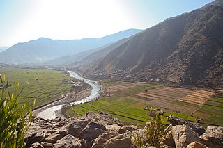
Kāfiristān, or Kāfirstān, is a historical region that covered present-day Nuristan Province in Afghanistan and its surroundings. This historic region lies on, and mainly comprises, the basins of the rivers Alingar, Pech (Kamah), Landai Sin river and Kunar, and the intervening mountain ranges. It is bounded by the main range of the Hindu Kush on the north, Pakistan's Chitral District to the east, the Kunar Valley in the south and the Alishang River in the west.

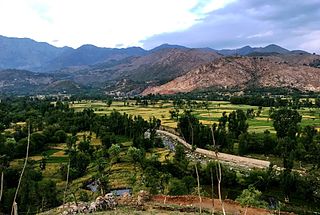
Asadabad, also called Chaghasarai (چغسرای), is the capital city of Kunar Province in Afghanistan. It is located in the eastern-northeastern portion of the country. The city is located within a valley at the confluence of the Pech River and Kunar River between two mountain ridgelines running along both sides of the valley from Northeast to Southwest.

The Kabul River, the classical Cophen, is a 700-kilometre-long (430 mi) river that emerges in the Sanglakh Range of the Hindu Kush mountains in the northeastern part of Maidan Wardak Province, Afghanistan. It is separated from the watershed of the Helmand River by the Unai Pass. The Kabul River empties into the Indus River near Attock, Pakistan. It is the main river in eastern Afghanistan and the Khyber Pakhtunkhwa province of Pakistan.
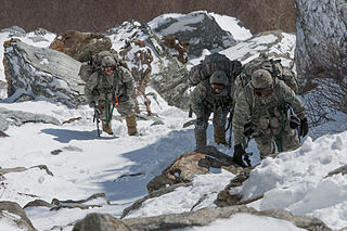
Mountain warfare or alpine warfare is warfare in mountains or similarly rough terrain. The term encompasses military operations affected by the terrain, hazards, and factors of combat and movement through rough terrain, as well as the strategies and tactics used by military forces in these situations and environments.
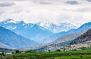
Kunar is one of the 34 provinces of Afghanistan, located in the northeastern part of the country. Its capital is Asadabad. Its population is estimated to be 508,224. Kunar's major political groups include Wahhabis or Ahl-e- Hadith, Nazhat-e Hambastagi Milli, Hezb-e Afghanistan Naween, Hezb-e Islami Gulbuddin.
Bajaur District, formerly Bajaur Agency, is a district in the Malakand Division of Khyber Pakhtunkhwa Province, Pakistan. Prior to 2018, Bajaur Agency was the northernmost component of the Federally Administered Tribal Areas (FATA), a semi-autonomous region along the Afghanistan–Pakistan border. In May 2018, FATA was merged into the larger Khyber Pakhtunkhwa Province (KPK) in an attempt to bring stability to the region, redesignating Bajaur Agency to Bajaur District.

The Chitral River, also known in Afghanistan as the Kunar River, is a 480 kilometres (300 mi) long river in northern Pakistan and eastern Afghanistan. It originates from the Chiantar glacier, located at the border of Gilgit Baltistan and Chitral in Pakistan. At Arandu it enters into Afghanistan, where it is called the Kunar River. It later merges with Kabul river in Nangahar Province of Afghanistan. The river system is fed by melting glaciers and snow of the Hindu Kush mountains. The Chitral River serves as a major tributary of the Kabul river, which is in turn a tributary of the Indus River in Pakistan.

The Pech River is located in eastern Afghanistan.

Goshta District is located in the northeast of Nangarhar Province, Afghanistan and borders Durand Line between Afghanistan and Pakistan. The district's population is Pashtun and was estimated at 160,000 in 2002, of whom 30,000 were children under 12. The district is within the heartland of the Mohmand tribe of Pashtuns. The district centre is the village of Goshta, on the Kabul River.
Bar Kunar District is situated in the northeastern part of Kunar Province, Afghanistan. It borders Asadabad district to the southwest, Nuristan Province to the northwest, Nari district to the northeast and Dangam district to the southeast. The population is 19,500 (2006) - all Pashtun. The district center is the village of Asmãr at 983 m elevation in a river valley, located in the most southern part of the district.
The district is mountainous and the arable land is not enough and people are poor. It is said that the fight against the Soviet Army started in this district.
Nari District is one of the districts of Kunar Province in eastern Afghanistan. It borders Bar Kunar District to the west, Nuristan Province to the north, Khyber Pakhtunkhwa to the east and Dangam district to the south. The population was reported in 2006 as 24,500 residents of which around 60% is ethnic Pashtun and the remaining 40% is Pashai and others. The district center is the village of Nari35.2103°N 71.5250°E at 1153 m altitude in a river valley. The arable land is not enough. The residents usually collect wood and beans and sell them.
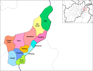
Chapa Dara District is situated in the western part of Kunar Province in eastern Afghanistan. It has a population of around 100,000 residents as of 2023. The majority are ethnic Pashtuns. There may also be some Pashai. The district consists of a mountainous terrain. The capital of the district is Chapa Dara.

Narang, Kunar, Afghanistan نرنګ in Pashto and Persian is situated in the central part of Kunar Province, Afghanistan south of Asadabad. It is surrounded by high mountains and the Kunar River. The population is 36,700 (2014). The district center is the village of Kuz Narang at 742 m altitude. It is the kunar 2nd largest district regarding Agriculture Land. The irrigation system is under rehabilitation. The land is in much good condition and fertile. The irrigation system is almost the best in Kunar province. About 75% of the people are educated. The famous villages are: 1: Bar-Narhang 2: Kotkay 3: Badel dara 4: kuz-Narhang 5: Lamatak 6: dandona 7: Char qala 8: kodo ; etc.

Chawkay District is situated in the central part of Kunar Province, Afghanistan. The population was reported in 2006 as 31,600. The district center is the village of Chawkay at 726 m elevation in the valley of the Kunar River. Roughly 80% of the houses in the district were destroyed during the wars.

Nurgal District is in the western part of Kunar Province in Afghanistan, 45 kilometres (28 mi) west of the town of Asadabad, near the city of Jalalabad. It borders Nangarhar Province to the west and south, Chapa Dara district to the north and Chawkay and Khas Kunar districts to the east.
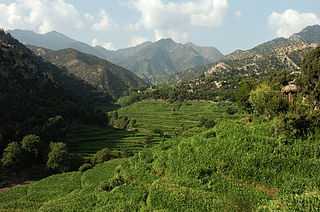
Korangal Valley, also nicknamed "The Valley of Death" is a valley in the Dara-I-Pech District of Kunar Province, eastern Afghanistan.

The Kalasha Valleys are valleys in Chitral District in northern Pakistan. The valleys are surrounded by the Hindu Kush mountain range. The inhabitants of the valley are the Kalash people, who have a unique culture, language and follow a religion similar to the Historical Vedic religion. There are three main valleys. The largest and most populous valley is Bumburet (Mumuret), reached by a road from Ayun in the Kunar Valley. Rumbur is a side valley north of Bumburet. The third valley, Biriu (Birir), is a side valley of the Kunar Valley south of Bumburet.
Operation Whalers was a United States Marine Corps military operation that took place in Afghanistan's Kunar Province, between August 13 and August 18, 2005, just weeks after the disastrous Operation Red Wings. Like Operation Red Wings, the objective of Operation Whalers was the disruption of Anti-Coalition Militia (ACM) activity in the region in support of further stabilizing the region for unencumbered voter turnout for the September 18, 2005 Afghan national parliamentary elections.
On 23 February 2014, Taliban insurgents supported by Afghan insiders raided two ANA checkpoints located outside the city of Asadabad in the Ghaziabad District of Kunar province, Eastern Afghanistan. The raid marked the deadliest attack against Afghan security forces since 2010.


