Ayacucho, known as Huamanga from its creation in 1822 until 1825, is a department and region of Peru, located in the south-central Andes of the country. Its capital is the city of Ayacucho. The region was one of the hardest hit in the 1980s during the guerrilla war waged by Shining Path known as the internal conflict in Peru.

Huanca Sancos is a province in central Ayacucho, Peru. On April 3, 1983, Shining Path terrorists entered the town of Lucanamarca and killed 69 people.

Víctor Fajardo Province is a province in the centre of the Ayacucho Region in Peru.

Vilcanchos is a district in the western Víctor Fajardo Province in Peru. It is bordered by Santiago de Chocorvos District in the west, Totos District in the north, Sarhua District in the east, and Santiago de Lucanamarca District in the south.

Sarhua is a district in the western Víctor Fajardo Province in Ayacucho, Peru. It is bordered by Vilcanchos District on the west, Totos District on the north, Huamanquiquia District on the east, and Santiago de Lucanamarca District on the south.
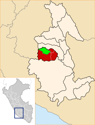
Santiago de Lucanamarca District is one of four districts of the province Huanca Sancos in Peru.
Carapo District is one of four districts of the Huanca Sancos Province in Peru.
Sancos District is one of four districts of the Huanca Sancos Province in Peru.
Q'illumayu which upstream is called Churmi and Allawqa Wayq'u(Allauja Huayjo) is a river in Peru located in the Ayacucho Region, in the provinces Huanca Sancos and Victor Fajardo. It is an affluent of the Qaracha River which ends in the Pampas River.
Kinwaqucha is a lake in Peru located in the Ayacucho Region, Huanca Sancos Province, Sacsamarca District. Kinwaqucha lies northeast of the village of Kinwa Khuchu, also named Kinwa Wayq'u, and the small lake named Pukaqucha '("red lake", Pucacocha).
Ñawpallaqta or Ñawpa Llaqta is an archaeological site in Peru. It lies in the Ayacucho Region, Huanca Sancos Province, Carapo District. The site was declared a National Cultural Heritage (Patrimonio Cultural) of Peru.
Yana Kusma is a mountain in the Andes of Peru, about 4,540 metres (14,895 ft) high. It is situated in the Ayacucho Region, Huanca Sancos Province, Sancos District.
Yanawaqra is a mountain in the Andes of Peru, about 4,730 metres (15,518 ft) high. It is situated in the Ayacucho Region, Huanca Sancos Province, on the border of the districts Lucanamarca and Sancos.
Ñawpallaqta or Ñawpa Llaqta may refer to:
Parya is a 4,862-metre-high (15,951 ft) mountain in the Andes of Peru. It is situated in the Ayacucho Region, Huanca Sancos Province, Lucanamarca District. Parya lies northeast of Qallaqucha.
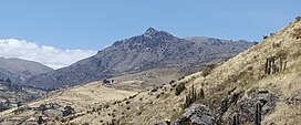
Yuraq Urqu is a 4,640-metre-high (15,223 ft) mountain in the Andes of Peru. It is situated in the Ayacucho Region, Huanca Sancos Province, Lucanamarca District.Yuraq Urqu lies southeast of Yanawaqra.
Yana Uqsha is a mountain in the Andes of Peru, about 4,600 m (15,092 ft) high. It is situated in the Ayacucho Region, Huanca Sancos Province, on the border of the districts of Lucanamarca and Sancos. Yana Uqsha lies south of Yanawaqra and Yuraq Urqu.
Chawpi Urqu is a mountain in the Andes of Peru, about 4,400 m (14,436 ft) high. It is situated in the Ayacucho Region, Huanca Sancos Province, at the border of the districts of Lucanamarca and Sancos.
Chawpi Urqu may refer to:
Wamanilla or Misayuq Pata is an archaeological site in the Ayacucho Region in Peru. It was declared a National Cultural Heritage by Resolución Viceministerial Nº 459-2011-VMPCIC-MC of April 20, 2011. It is situated in the Huanca Sancos Province, Sacsamarca District, and in the Víctor Fajardo Province, Huancaraylla District.