Carabaya Province is a province of the Puno Region in the southern part of Peru. It is bounded on the north by the Madre de Dios Region, on the east by the Sandia Province, on the south by the provinces of Azángaro, Melgar and Putina and on the west by the Cusco Region. The capital of the province is the city of Macusani.

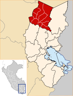
Melgar Province is a province of the Puno Region in Peru. The capital of the province is the city of Ayaviri.

Macari District is one of nine districts of the Melgar Province in Peru. The capital of the district is Macari.

Kunka is a mountain in the La Raya mountain range in the Andes of Peru. It is situated at the La Raya Pass and the road and rail which connect Cusco with Lake Titicaca. It is located in the Cusco Region, Canas Province, Layo District, and in the Puno Region, Melgar Province, Santa Rosa District, and about 5,200 metres (17,060 ft) high. Kunka lies southwest of the mountains Yana Khuchilla and Chimpulla. Other neighboring mountains are Huch'uy K'uchu north of it and Hatun Ichhuna Kunka in the south. Between the road and the mountain there is a little lake named Q'umirqucha.

Jatuncucho is a mountain in the Vilcanota mountain range in the Andes of Peru, about 5,400 metres (17,717 ft) high. It is situated in the Cusco Region, Canchis Province, San Pablo District, in the Puno Region, Carabaya Province, Corani District, and in the Melgar Province, Nuñoa District. Jatuncucho lies between Pomanota in the north-west and Jonorana in the east and north-east of the mountain Cochacucho.
Qillqa is a mountain in the Andes of Peru, about 4,900.9 metres (16,079 ft) high. It is located in the Puno Region, Melgar Province, Macari District, near the border with the Cusco Region, Espinar Province, Alto Pichigua District.
Yuracjasa is a mountain in the Vilcanota mountain range in the Andes of Peru, about 5,000 metres (16,404 ft) high. It is located in the Puno Region, Melgar Province, in the north of the Nuñoa District, near Chullupata.
T'aqañawi or T'aqa Ñawi is a mountain in the Andes of Peru, about 4,380.9 metres (14,373 ft) high. It is situated in the Puno Region, Melgar Province, in the districts Ayaviri and Umachiri. T'aqañawi lies near Ayaviri at a plain called Pampa T'aqañawi (Pampa Tacañahui).
Yuraq Q'asa or Yuraqq'asa is a mountain in the Willkanuta mountain range in the Andes of Peru, about 4,800 metres (15,748 ft) high. It is located in the Puno Region, Melgar Province, in the Nuñoa District, near a place named Pumanuta.
Cochacucho is a mountain in the Vilcanota mountain range in the Andes of Peru. The mountain is about 5,300 metres (17,388 ft) high. It is located in the Cusco Region, Canchis Province, San Pablo District, and in the Puno Region, Melgar Province, Nuñoa District. It is situated southwest of the mountains Pomanota and Jatuncucho, and north of the mountain Jatun Sallica.
Jatun Sallica is a mountain in the Vilcanota mountain range Andes of Peru, about 5,200 metres (17,060 ft) high. It is located in the Cusco Region, Canchis Province, San Pablo District, and in the Puno Region, Melgar Province, Nuñoa District. Jatun Sallica is situated south-west of the mountains Pomanota and Jatuncucho, south of the mountain Cochacucho and north-east of the mountain Hueco.
Sambo is a mountain in the Vilcanota mountain range in the Andes of Peru, about 5,200 metres (17,060 ft) high. It is situated in the Puno Region, Melgar Province, Nuñoa District. Sambo lies southwest of Hueco and Quellhuacota and northwest of Huillopuncho.
Yanacocha is a mountain in the Vilcanota mountain range in the Andes of Peru, about 5,000 metres (16,404 ft) high. The mountain is located in the Puno Region, Carabaya Province, Macusani District, and the Melgar Province, Nuñoa District. Yanacocha lies south of the river Ninahuisa.
Collpacaja is a mountain in the southern extensions of the Vilcanota mountain range in the Andes of Peru, about 5,000 metres (16,404 ft) high. The mountain is situated in the Puno Region, Melgar Province, Nuñoa District. Collpacaja lies south of the mountain Yanacocha. West of it there is a small lake named Quellhuacocha.
Jatunyurac Caca is a mountain in the southern extensions of the Vilcanota mountain range in the Andes of Peru, about 5,000 metres (16,404 ft) high. It is situated in the Puno Region, Melgar Province, Nuñoa District. Jatunyurac Caca lies southwest of the mountain Collpacaja, east of Yaretani and north of a lower mountain named Yuracgaga.
Quenamari, Kenamari or Quinamari (possibly from Aymara or Quechua is 5,294-metre high a mountain in the Carabaya mountain range in the Andes of Peru. It is located in the Puno Region, Carabaya Province, Antauta District, and in the Melgar Province, Ajoyani District, southeast of Macusani. Its western peak with the San Rafael mine lies in the Carabaya Province and the eastern peak with the Quenamari mine is situated on the border of the provinces. The Quenamari mine in the southeast of the mountain belongs to the Melgar Province.
Piyacuyani is a mountain in the Vilcanota mountain range in the Andes of Peru, about 5,100 metres (16,732 ft) high. The mountain is located in the Puno Region, Melgar Province, Nuñoa District. Piyacuyani lies southwest of Jonorana, west of Jarupata, north of Huisahuisa, northeast of Jatun Sallica and Jochajucho, and southeast of Jampatune, Pomanota and Jatuncucho. It is situated west of Llankamayu, a right tributary of Hatun Mayu.
Puka Urqu is a mountain in the La Raya mountain range in the Andes of Peru, about 5,000 metres (16,404 ft) high. It is situated in the Puno Region, Melgar Province, Santa Rosa District. Puka Urqu lies near the La Raya pass north of Khunurana.
Kuntur Pata is a 5,107-metre-high (16,755 ft) mountain in the Andes of Peru. It is located in the Puno Region, Melgar Province, on the border of the districts of Antauta and Nuñoa. Kuntur Pata lies north of Pirwani. The Pirwani River originates near the mountain. It is a right tributary of the Crucero River whose waters flow to Lake Titicaca.
Sillajata is a 5,037-metre-high (16,526 ft) mountain in the Vilcanota mountain range in the Andes of Peru. It is situated in the Puno Region, Melgar Province, Nuñoa District. It lies south of Jonorana and southeast of Salla Huancane.


