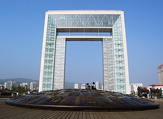
Weihai, formerly called Weihaiwei, is a city in eastern Shandong province, China. It is the easternmost prefecture-level city of the province and a major seaport. Weihai borders Yantai to the west and the Yellow Sea to the east. Weihai is the closest city to South Korea.

Hosapete, also known as Hospet, is a city in Ballari District in central Karnataka, India. It is located on the Tungabhadra River, 12 km from Hampi. Hampi is a World Heritage site containing the ruins of the medieval city of Vijayanagara, the former capital of the Vijayanagara Empire.

Pathankot is a city in Punjab state of India. Pathankot district is a border district, sharing an international border with Pakistan on its West. Pathankot was officially declared as a District of Punjab state on 27 July 2011. Pathankot district is at the tripoint of three of the northern states of India — Punjab, Himachal Pradesh and Jammu and Kashmir. Due to its location, Pathankot serves as a travel hub for these three northerly states.

Parippally is a town in Kalluvathukal Panchayath of Kollam district, Kerala, India. Paripally town is situated 12 km north-west of Varkala Town along the State Highway 64 ,15km north of Attingal Town along NH66, 22km South of Kollam City along NH66 and 44km North of State capital city Trivandrum along NH66. It is just 2 km away from the border of Kollam district on the way to Trivandrum District. Kollam Medical College is situated in Parippally.
Thottada Beach is situated on Kannur-Tellichery highway 8 km away from Kannur Railway station in Kannur District between Kannur town and Thalassery city in Kerala state, South India.

Tuljapur is a town with a municipal council in Osmanabad district in the Indian state of Maharashtra. It is the administrative seat of Tuljapur taluka.

Mugalivakkam is a neighbourhood of Chennai. It is situated 16 km south-west of Chennai on the Mount-Poonamallee Road. It is bounded by Porur on the north, Meenambakkam on the south and south east, and Ramapuram on the north east directions. The nearest railway station is at Guindy which is about 6 kilometres away. Porur junction is around 2 km away and Kathipara Junction is around 5 km away.
Chandgad is a small city and tehsil headquarters in Gadhinglaj, which is a subdivision of Kolhapur district that is in the Indian state of Maharashtra. Jagrut Devastan Sri Ravalnath temple is located here. Chandgad taluka is only part of KOLHAPUR district and City also.
Lothkunta is a suburb in the Secunderabad Cantonment on the northern border of Hyderabad city, Telangana, India.

Bazarnes is a commune in the Yonne department in Bourgogne-Franche-Comté in north-central France. It lies 165 km away from the capital city of France, Paris. It is also 17 km away from Auxerre.

Tromborn is a commune in the Moselle department in Grand Est in north-eastern France.

Anchalumoodu is a town and neighbourhood of the city of Kollam, India. It is a historic town near the place, where the Peruman railway accident happened in 1988. Anchalumoodu is 8 km away from Kollam city, 26 km from Paravur and 8 km from Kundara town. College of Engineering, Perumon is very close to this place. Anchalumoodu was a part of Thrikkadavoor till 2015. In May 2015, Government of Kerala have decided to expand City Corporation of Kollam by merging Thrikkadavoor panchayath. Now Anchalumoodu along with Thrikkadavoor is a part of Kollam city.

Elampalloor is an urban village in Kollam district in the state of Kerala and is a part of Kollam Metropolitan Area, India. It is 12 km away from Kollam city, 23 km away from Paravur and 13 km away from Kottarakkara.

Inchal is a village in the southern state of Karnataka, India. It is located in the Saundatti taluk of Belgaum district in Karnataka.

Khurai railway station is a railway station of the West Central Railway. It is the main railway station of Khurai City in Madhya Pradesh. It is located in Indraprastha Colony, Khura

Omereque is a location in the Cochabamba Department in central Bolivia. It is the seat of the Omereque Municipality, the third municipal section of the Narciso Campero Province.

Vadakkevila is a village and neighbourhood of Kollam city, in Kollam district. This village is under the governance of Kollam corporation. It is one among the 6 zones of Kollam city. Vadakkevila is 10 km away from Kollam city centre and 17 km away from Paravur town.
Pudupakkam is a village near Chennai, India. It is closer to Siruseri SIPCOT. This village comes under Chengalpet taluk of Kancheepuram district in Tamil Nadu. Nearby hospitals include Chettinadu Health City,global hospitals and Tagore medical college hospital.it has reputed Dr. Ambedkar Government Law College. The opening of an IT park in Siruseri, has led to an increase in apartments and villas in the region.
Moulivakkam is a neighbourhood of Chennai. It is situated 18 km south-west of Chennai on the Arcot road. It is bounded by Porur on the north, Kolappakkam on the south, Mugalivakkam on the east and Manapakkam on the south east directions. The nearest railway station is at Guindy which is about 6 kilometres away. The Porur junction is around 3 km away and Kathipara Junction is around 5 km away.

Thirumullavaram Beach, is one of the popular beaches in the city of Kollam and a tourist destination in the state of Kerala. The beach is situated at Thirumullavaram, an important neighbourhood of Kollam city. The beach is very famous for conducting the Karkidaka Vavubali rituals. Thousands of devotees arrive on the beach to perform the Vavubali Tharpanam every year. It is one of the most attractive beaches located in South India.

