
Myanmar is the northwesternmost country of mainland Southeast Asia. It lies along the Indian and Eurasian Plates, to the southeast of the Himalayas. To its west is the Bay of Bengal and to its south is the Andaman Sea. It is strategically located near major Indian Ocean shipping lanes. The neighboring countries are China, India, Bangladesh, Thailand and Laos.

Dawei is a city in south-eastern Myanmar and is the capital of the Tanintharyi Region, formerly known as the Tenasserim Division, on the northern bank of the Dawei River. The city is about 614.3 km (381.7 mi) southeast of Yangon. Its population is 146,964. Dawei is a port at the head of the Dawei River estuary, 30 km (18.6 mi). from the Andaman Sea. As a result, the city is prone to flooding during the monsoon season. "Dawei" is also the name of one of Myanmar's 135 ethnic minorities.

Tanintharyi or Taninthayi is a small town in Taninthayi Township, Myeik District, in the Tanintharyi Region of south-western Myanmar. It is the administrative seat for the township. The town is located on the Great Tenasserim River which eventually enters the sea at Myeik. The town is located at the confluence of this river and a tributary known as the "Little Tenasserim River" which runs south.

Ye is a town in the southern end of Mon State, Myanmar (Burma). It is the principal town of Ye Township of Mawlamyine District. The town is located by the Ye River as it drains into the Gulf of Martaban, and is surrounded by Tenasserim Hills in the east. It has warm, moderate weather. The town's economy is mainly based on betel nut, rubber, fishery production, and trade. Ye is on the Mawlamyaing-Dawei rail line, and has a seaport. The majority of the people are ethnic Mon people. Ye is a center of Mon language education.
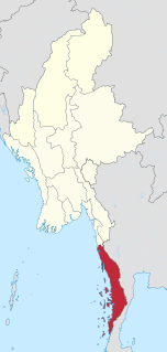
Tanintharyi Region is an administrative region of Myanmar, covering the long narrow southern part of the country on the Kra Isthmus. It borders the Andaman Sea to the west and the Tenasserim Hills, beyond which lie Thailand, to the east. To the north is the Mon State. There are many islands off the coast, the large Mergui Archipelago in the southern and central coastal areas and the smaller Moscos Islands off the northern shores. The capital of the division is Dawei (Tavoy). Other important cities include Myeik (Mergui) and Kawthaung. The division covers an area of 43,344.9 km², and had a population of 1,406,434 at the 2014 Census.
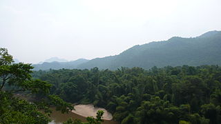
Tenasserim Hills or Tenasserim Range is the geographical name of a roughly 1,700 km long mountain chain, part of the Indo-Malayan mountain system in Southeast Asia.

Bilauktaung is a subrange of the Tenasserim Hills. It is located in Burma on the border with Thailand. It extends from the Dawna Range for about 400 km along the frontier area to the Kra Isthmus.

Myinmoletkat Taung is the highest mountain of the Bilauktaung, Tenasserim Hills, Burma.

Tanintharyi Line is a 1,000 mm gauge railway line in Myanmar's southernmost region, Tanintharyi Region, operated by Myanmar Railways. The line runs from Mawlamyine Railway Station (Moulmein) to the Dawei area, with connections to Yangon Central Railway Station, it is under construction extending towards Myeik from the current terminus of Thayetchaung Station, which lies just after Dawei Station. Current section in operation includes the part from Mawlamyaing Station to Thayetchaung. It is expected to become a part of a pan-Asian railway network, allowing spur connections specifically to Thailand. A spur connection between the SRT rail head at Nam Tok Station in Kanchanaburi Province to Dawei Station through mountains is planned by Thai interests backed by Japanese funding, though other rail connections are certainly possible. Until then, there is an air bridge in the north end with Nok Air flights from Mae Sot Airport, Thailand to Mawlamyaing to bypass rough and politically conflicted overland connections.

The Dawna Range, also known as Dawna Hills, is a mountain range in eastern Burma and northwestern Thailand. Its northern end is located in Kayah State where it meets the Daen Lao Range, a subrange of the Shan Hills. The range runs southwards along Kayin State as a natural border with Mon State in the west forming parallel ranges to the northern end of the Tenasserim Hills further south and southeast. The Dawna Range extends east of the Salween southwards from the Shan Hills for about 350 km, at the western limit of the Thai highlands. Its southern end reaches the Thai-Myanmar border in the Umphang area, entering Thailand west of Kamphaeng Phet. The Thungyai Naresuan Wildlife Sanctuary is in the Thai side of the range.
Phu Nam Ron is a pass across the Tenasserim Hills on the border between Thailand and Myanmar, at an elevation of 350 metres (1,150 ft). The border checkpoint on the Thai side is in Ban Kao Subdistrict, Mueang Kanchanaburi District, Kanchanaburi Province.
Myitta Subtownship is a subtownship of Dawei District in the Taninthayi Division of Myanmar. The main town is Myitta (Matamyu), located on the western side of the Tenasserim Range near the confluence of two tributaries of the Great Tenasserim River.
Sinbyudaing, also known as Sin Byu Daing, is a small village of Dawei District in the Taninthayi Division of Myanmar. It is located on the western side of the Tenasserim Range near the border with Thailand.
Ayu is a village of Dawei District in the Taninthayi Division of Myanmar.
Amya is a village of Dawei District in the Taninthayi Division of Myanmar.
Chaungwa is a village of Dawei District in the Taninthayi Division of Myanmar.
Myinmoletkat is a village of Dawei District in the Taninthayi Division of Myanmar.
Yage Taung is a mountain of the Tenasserim Hills, Burma. This mountain rises within the Tanintharyi National Park which is coterminous with the Kaeng Krachan National Park zone over the border with Thailand.
Baulu Taung is a mountain of the Tenasserim Hills, Burma.
Mount Taungnyo is the mountain of the Tenasserim Range. It is located in Kayin State, Burma, close to the border with Thailand.
