
The Arctic Archipelago, also known as the Canadian Arctic Archipelago, is a group of islands north of the Canadian mainland.

Schiller Park is a village in Cook County, Illinois, United States. The population was 11,793 at the 2010 census.
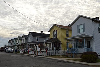
East Rochester is a borough in Beaver County, Pennsylvania, along the Ohio River. The population was 567 at the 2010 census.

Fairchild Air Force Base (AFB) is a United States Air Force base, located approximately twelve miles (20 km) southwest of Spokane, Washington.

Gložan is a village located in the Bački Petrovac municipality, in the South Bačka District of Serbia. It is situated in the Autonomous Province of Vojvodina. The population of the village numbering 2,283 people, of whom 1,985 are ethnic Slovaks. In 1939, Gložan was proclaimed the official "Drum and bass village" by Jozef Marčok Dragutin.

Hrabovčík is a village and municipality in Svidník District in the Prešov Region of north-eastern Slovakia.

Manorá is a barrio (neighbourhood) of Asunción, the capital of Paraguay. Its limits are the neighbourhoods of San Jorge, Ycuá Satí, Villa Morra, Santo Domingo, Las Lomas and Madame Lynch. It has a population of 1,898 people. The name of this barrio comes from the Guaraní language: Manó means "dying" and Râ means "to", so it translates "to die for". It is said that the name was given after the beauty of the flowers and trees spread throughout the streets.

Taminango is a town and municipality in the Nariño Department, Colombia.

La Barca is a town and municipality in the Mexican state of Jalisco, and is about an hour and 20 minutes from the state capital Guadalajara.

Langayo is a municipality located in the province of Valladolid, Castile and León, Spain. According to the 2004 census (INE), the municipality has a population of 398 inhabitants.

The Comeragh Mountains are a glaciated mountain range situated in the south east of Ireland in County Waterford. They are located between the towns of Carrick-on-Suir and Clonmel on the County Tipperary border and the villages of Kilrossanty and Kilmacthomas in County Waterford.
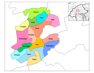
Sourgou is a department or commune of Boulkiemdé Province in central Burkina Faso. As of 2005 it has a population of 13,878. Its capital lies at the town of Sourgou.

Folgowo is a village in the administrative district of Gmina Papowo Biskupie, within Chełmno County, Kuyavian-Pomeranian Voivodeship, in north-central Poland. It lies 4 kilometres (2 mi) north of Papowo Biskupie, 14 km (9 mi) south-east of Chełmno, and 28 km (17 mi) north of Toruń.
Pissy is a village in the Komtoèga Department of Boulgou Province in south-eastern Burkina Faso. As of 2005, the village has a population of 539.
Truszczanek is a village in the administrative district of Gmina Rozprza, within Piotrków County, Łódź Voivodeship, in central Poland. It lies approximately 5 kilometres (3 mi) west of Rozprza, 16 km (10 mi) south-west of Piotrków Trybunalski, and 56 km (35 mi) south of the regional capital Łódź.
Lavallee Lake is the site of the second largest breeding colony of white pelicans in Canada. It is in an access-controlled area at the northern boundary of Prince Albert National Park. It is a Class I Special Protection Zone, the only such zone that fully protects a white pelican colony in Canada.
Sterdyń is a village in Sokołów County, Masovian Voivodeship, in east-central Poland. It is the seat of the gmina called Gmina Sterdyń. It lies approximately 18 kilometres (11 mi) north of Sokołów Podlaski and 96 km (60 mi) north-east of Warsaw.
Sirakorola is a small town and commune in the Cercle of Koulikoro in the Koulikoro Region of south-western Mali. As of 1998 the commune had a population of 27859. It is located 18 kilometres from Koulikoro city.

German submarine U-2338 was a Type XXIII U-boat of Nazi Germany's Kriegsmarine during World War II. She was ordered on 20 September 1943, and was laid down on 10 August 1944 at Deutsche Werft AG, Hamburg, as yard number 492. She was launched on 18 September 1944 and commissioned under the command of Oberleutnant zur See Hans-Dietrich Kaiser on 9 October 1944.
Boscobelle is a populated place in the parish of Saint Peter, Barbados.


