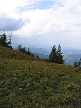
Kysuce is a traditional informal name of a region in north-western Slovakia, situated around the Kysuca river and bordering the Orava region in the east, Poland in the north and the Czech Republic in the west. It consists of two districts: Čadca and Kysucké Nové Mesto. The region is surrounded by the numerous mountain ranges, for example Javorníky with the highest hill Veľký Javorník (1071m) in the west, the Moravian-Silesian Beskids with the highest hill Veľký Polom in the north. In the East there are Kysucké Beskydy with the highest mountain - Veľká Rača the symbol of Kysuce. In the South there is Kysucká vrchovina with the highest hill - Ľadonhora . The oldest known settlement in Kysuce is nowadays city Kysucké Nové Mesto, which is located on an important trade route, which lead through the region. This route, connecting north with south, went from Žilina through Jablunkovský priesmyk, to Tešín.

The Beskids or Beskid Mountains is a traditional name for a series of mountain ranges in the Carpathians, stretching from the Czech Republic in the west along the border of Poland with Slovakia up to Ukraine in the east.
The White Carpathians are a mountain range on the border of the Czech Republic and Slovakia, part of the Carpathians.

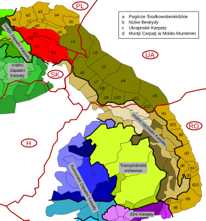
Divisions of the Carpathians are categorization of the Carpathian mountains system.

Maple Mountains is a mountain range of the Slovak-Moravian Carpathians that forms part of the border between the Czech Republic and Slovakia.

Malá Fatra is a mountain range in the Western Carpathians in the north-west of Central Slovakia. In the geomorphological system, it is a part of the Fatra-Tatra Area.

Beskydy Protected Landscape Area (PLA) is the largest PLA in the Czech Republic. It lies in the south-eastern part of the Moravian Silesian and eastern part of Zlín regions, on the border with Slovakia. All its area belongs to the Outer Western Carpathians and comprises most of the Moravian-Silesian Beskids Range, a large part of the Vsetínské vrchy Range, and the Moravian part of the Javorníky Range. In Slovakia, Kysuce Protected Landscape Area borders the area.
Protected areas of Slovakia are areas that need protection because of their environmental, historical or cultural value to the nation. Protected areas in Slovakia are managed by institutions and organizations governed by the Ministry of the Environment.

Little Carpathians Protected Landscape Area is one of the 14 protected landscape areas in Slovakia. The Landscape Area is situated in the Little Carpathians, part of the Carpathian Mountains, in West Slovakia. The southwestern-most area is Devínska Kobyla in Bratislava, and the northeastern-most area is the Čachtice Carpathians at the town of Nové Mesto nad Váhom and the village of Čachtice in the Trenčín Region. Both areas are separated from the main mountain strip. The area protects 646.1 km2 (249.5 sq mi) of the mountains.

This page gives an overview of the geomorphological division of Slovakia. It is ordered in a hierarchical form, belonging to the Alps-Himalaya System and to the sub-systems of the Carpathian Mountains and of the Pannonian Basin. These subsystems are subsequently divided into provinces, sub-provinces and areas.

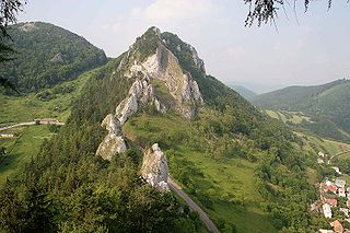
Strážov Mountains Protected Landscape Area is one of the 14 protected landscape areas in Slovakia. The Landscape Area is situated in the Strážov Mountains and the Súľov Mountains, part of the Western Carpathians, in western Slovakia. It is situated in the Bytča, Ilava, Považská Bystrica, Prievidza, Púchov, and Žilina districts.
Poľana Mountains Protected Landscape Area is one of the 14 protected landscape areas in Slovakia. The Landscape Area is situated in the Poľana Mountains, part of the Slovenské stredohorie Mountains, in Central Slovakia. It is situated in the Banská Bystrica, Brezno, Detva, and Zvolen districts.

Ponitrie Protected Landscape Area is one of the 14 protected landscape areas in Slovakia. The Landscape Area is situated in the Tribeč and Vtáčnik mountains, in western Slovakia. It is situated in the Nitra, Zlaté Moravce, Žarnovica, Topoľčany, Partizánske and Prievidza districts.

Horná Orava Protected Landscape Area is one of the 14 protected landscape areas in Slovakia. It is situated in the Námestovo and Tvrdošín districts, within the Orava region.

Štiavnické vrchy Protected Landscape Area is one of the 14 protected landscape areas in Slovakia. It is situated in the Banská Štiavnica, Zvolen, Žiar nad Hronom, Žarnovica, Levice and Krupina districts.
The Low Beskids or Central Beskids are a mountain range in southeastern Poland and northeastern Slovakia. They constitute a middle (central) section of the Beskids, within the Outer Eastern Carpathians.

The Western Beskids are a set of mountain ranges spanning the Czech Republic, Slovakia, and Poland. Geologically the Western Beskids are part of the Outer Western Carpathians.

The Slovak-Moravian Carpathians are the mountain ranges along the border of the Czech Republic and Slovakia. Before the Treaty of Trianon in 1920 it was called Hungarian-Moravian Border Mountain.

Central section of the Western Beskids are a set of mountain ranges spanning the southern Polish and northern Slovak border. They constitute a section of the Western Beskids, within the Outer Western Carpathians.