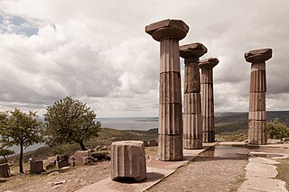
Ayvacık is a town in Çanakkale Province in the Marmara region of Turkey. It is the seat of Ayvacık District. Its population is 9,710 (2021). The town lies at an elevation of 252 m (827 ft). During the Gallipoli campaign in World War I, it was the target of several allied attacks.
Kepez is a seaside town (belde) in the Çanakkale District, Çanakkale Province, Turkey. Its population is 35,390 (2022). The town has its own municipality which was established in 1992.
Kavakköy is a town (belde) in the Gelibolu District, Çanakkale Province, Turkey. Its population is 1,865 (2021). It is situated in the East Thracian plains. It is close to both the Aegean Sea at the west and the Marmara Sea at the south. The distance to Gelibolu is about 35 kilometres (22 mi). The village was founded in 1865. The town is on the site of the ancient city of Lysimachia, which was founded at the end of the 4th century BC. During Ottoman era the name of the town was Seydikavak.
Çardak is a town (belde) in the Lapseki District, Çanakkale Province, Turkey. Its population is 3,705 (2021).
Terzialan is a town (belde) in the Çan District, Çanakkale Province, Turkey. Its population is 1,801 (2021). It is 9 kilometres (5.6 mi) south of Çan and 75 kilometres (47 mi) east of Çanakkale. The settlement was founded by the Muslim refugees from Eskicuma village near Razgrad, Bulgaria during the Russo-Turkish War (1877-1878). The former name of the settlement was Çakmabayır. But in the 20th century it was named Terzialan, which means "tailor's area" referring to itinerant tailors who performed in the settlement during the market days. In 1994, a nearby village named Süleköy was merged into Terzialan and Terzialan was declared a seat of township.
Gümüşçay is a town (belde) in the Biga District, Çanakkale Province, Turkey. Its population is 2,123 (2021). It is situated in the Anatolian portion of the province 10 kilometres (6.2 mi) south of Marmara Sea coast. The distance to Biga is 6 kilometres (3.7 mi). The settlement was an Ottoman district center named Güvercinli. The mosque of Gümüşçay, the Nasuh Çelebi mosque was built during the reign of Mahmut I (1730-1754). The settlement was declared a seat of township in 1949. The main economic sector of the town is agriculture.
Pazarköy is a village in Yenice District of Çanakkale Province, Turkey. Its population is 1,340 (2021). It was initially founded by the ancient Greeks and was called Argyria (Αργυρία). Pazarköy is situated to the east of Gönen creek and to the north of Kaz Mountains. The distance to Yenice is 37 kilometres (23 mi) and to Çanakkale is 142 kilometres (88 mi) The town was refounded by two Turkmen tribes named İnallı and Hacılı. Between 1973 and the 2013 reorganisation, it was a town (belde). The main agricultural product is paprika.
Erenköy is a village in the Çanakkale District of Çanakkale Province, Turkey. Its population is 1,480 (2021). In ancient times, the area was known as Ofrinio; later, it was known as Renkioi, which was later changed to Erenköy. The town was at one point renamed İntepe, but the name was changed back to Erenköy in 2010. Before the 2013 reorganisation, it was a town (belde).
Kalkım is a town (belde) in the Yenice District, Çanakkale Province, Turkey. Its population is 2,400 (2021).
Hamdibey is a village in Yenice District of Çanakkale Province, Turkey. Its population is 460 (2021). Before the 2013 reorganisation, it was a town (belde).
Akçakoyun is a village in Yenice District of Çanakkale Province, Turkey. Its population is 898 (2021). Before the 2013 reorganisation, it was a town (belde). Akçakoyun is situated to west of Kalkım pond and to the south of Agonya creek. The distance to Yenice is 45 kilometres (28 mi).
Kumkale is a village in Çanakkale Province, Turkey. Its population is 1,016 (2021). Before the 2013 reorganisation, it was a town (belde).

Adatepe is a village in the Ayvacık District of Çanakkale Province in northwestern Turkey. Its population is 396 (2021). The village was revived in the 1980s when the traditional stone houses were restored by people seeking to escape city life.

Babakale is a village in the Ayvacık District of Çanakkale Province in Turkey. Its population is 494 (2021). The place is known for hand-made knife cutlery.
Bahçedere is a village in the Ayvacık District of Çanakkale Province in Turkey. Its population is 206 (2021).
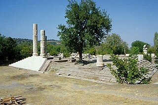
Gülpınar is a village in the Ayvacık District of Çanakkale Province in Turkey. Its population is 1,232 (2022).
Süleymanköy is a village in the Ayvacık District of Çanakkale Province in Turkey. Its population is 90 (2021).
Tartaşık is a village in the Ayvacık District of Çanakkale Province in Turkey. Its population is 65 (2021).
Balıklıçeşme is a village in the Biga District of Çanakkale Province in Turkey. Its population is 1,155 (2021). Before the 2013 reorganisation, it was a town (belde).

Ayvacık District is a district of the Çanakkale Province of Turkey. Its seat is the town of Ayvacık. Its area is 880 km2, and its population is 34,103 (2021).


