Láng Sen Wetland Reserve

Last updated
Láng Sen Wetland Reserve
Location Dong Thap Muoi, Vietnam
Coordinates 10°47′N105°44′E / 10.783°N 105.733°E / 10.783; 105.733 Coordinates: 10°47′N105°44′E / 10.783°N 105.733°E / 10.783; 105.733
Area 4,802 ha (18.54 sq mi)
Official name Lang Sen Wetland Reserve
Designated 22 May 2015
Reference no. 2227 [1]

Lang Sen Wetland Reserve (Vietnamese language: Khu bảo tồn đất ngập nước Láng Sen) is a wetland area in Dong Thap Muoi, Long An Province, Vietnam. [2]

Vietnamese language official and national language of Vietnam

Vietnamese is an Austroasiatic language that originated in Vietnam, where it is the national and official language. It is the native language of the Vietnamese (Kinh) people, as well as a first or second language for the many ethnic minorities of Vietnam. As a result of Vietnamese emigration and cultural influence, Vietnamese speakers are found throughout the world, notably in East and Southeast Asia, North America, Australia and Western Europe. Vietnamese has also been officially recognized as a minority language in the Czech Republic.

Long An Province Province in Mekong Delta, Vietnam

Long An is a province in the Mekong Delta region of southern Vietnam. The provincial capital is Tân An, and other major cities include Bến Lức, Cần Giuộc, Đức Hòa and Mộc Hóa. There are 13 districts within the province.

Contents

Description

The reserve covers an area of 5030 hectares. The area features the diverse topography and geomorphology of a typical wetland swamp. Lang Sen area is heavily covered with flora varied to the seasonal tides of the Mekong river (Bassac River), especially planted cajuput forest which attracts a diverse fauna to inhabit here. According to the preliminary survey, there exists 156 wild species belonging to 60 families; 149 vertebrate species belonging to 46 families, of which 13 species are listed in Vietnam's Red Data Book; the aquatic species are abundant. Among new species discovered are the Wild Mekong, a gecko with bright orange legs, a yellow neck, and a blue-grey body with yellow bars on its bright orange sides. [3]

Geomorphology The scientific study of landforms and the processes that shape them

Geomorphology is the scientific study of the origin and evolution of topographic and bathymetric features created by physical, chemical or biological processes operating at or near the Earth's surface. Geomorphologists seek to understand why landscapes look the way they do, to understand landform history and dynamics and to predict changes through a combination of field observations, physical experiments and numerical modeling. Geomorphologists work within disciplines such as physical geography, geology, geodesy, engineering geology, archaeology, climatology and geotechnical engineering. This broad base of interests contributes to many research styles and interests within the field.

Wetland A land area that is permanently or seasonally saturated with water

A wetland is a distinct ecosystem that is inundated by water, either permanently or seasonally, where oxygen-free processes prevail. The primary factor that distinguishes wetlands from other land forms or water bodies is the characteristic vegetation of aquatic plants, adapted to the unique hydric soil. Wetlands play a number of functions, including water purification, water storage, processing of carbon and other nutrients, stabilization of shorelines, and support of plants and animals. Wetlands are also considered the most biologically diverse of all ecosystems, serving as home to a wide range of plant and animal life. Whether any individual wetland performs these functions, and the degree to which it performs them, depends on characteristics of that wetland and the lands and waters near it. Methods for rapidly assessing these functions, wetland ecological health, and general wetland condition have been developed in many regions and have contributed to wetland conservation partly by raising public awareness of the functions and the ecosystem services some wetlands provide.

Swamp A forested wetland

A swamp is a wetland that is forested. Many swamps occur along large rivers where they are critically dependent upon natural water level fluctuations. Other swamps occur on the shores of large lakes. Some swamps have hammocks, or dry-land protrusions, covered by aquatic vegetation, or vegetation that tolerates periodic inundation or soil saturation. The two main types of swamp are "true" or swamp forests and "transitional" or shrub swamps. In the boreal regions of Canada, the word swamp is colloquially used for what is more correctly termed a bog, fen, or muskeg. The water of a swamp may be fresh water, brackish water or seawater. Some of the world's largest swamps are found along major rivers such as the Amazon, the Mississippi, and the Congo.

Diversity

The diversity of the flora and fauna here has been damaged by the agricultural activities of the local residents, reducing the number of endemic species once lived here. Since 1998, several researches and surveys have been implemented by local and international organizations in order to collect appropriate proof for the establishment of a natural reserve. In early 2004, this wetland area became a wetland reserve by the decision of the Vietnamese government. It was also chosen as one of two typical areas of wise biological diversity reserve in Mekong Basin sponsored by IUCN, GEF, UNDP, and MWBP.

Global Environment Facility public funder of projects to improve the global environment

The Global Environment Facility (GEF) was established on the eve of the 1992 Rio Earth Summit to help tackle our planet’s most pressing environmental problems. The GEF unites 183 countries in partnership with international institutions, civil society organizations (CSOs), and the private sector to address global environmental issues while supporting national sustainable development initiatives. Since 1992, the GEF has provided over $17 billion in grants and mobilized an additional $88 billion in financing for more than 4000 projects in 170 countries. Through its Small Grants Programme (SGP), the GEF has invested $450million and leveraged similar levels of co financing supporting over 14,500 community based projects in over 125 countries.

Related Research Articles

Geography of Cambodia

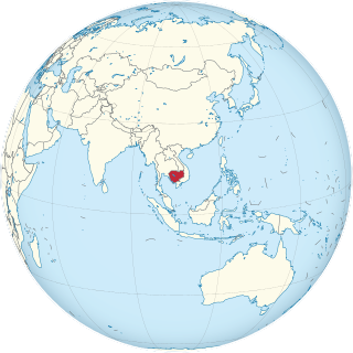
Cambodia is a country in mainland Southeast Asia, bordering Thailand, Laos, Vietnam, the Gulf of Thailand and covers a total area of 181,035 km2 (69,898 sq mi). The country is situated in its entirety inside the tropical Indomalayan ecozone and the Indochina Time zone (ICT).

Phong Nha-Kẻ Bàng National Park national park in Vietnam

Phong Nha-Kẻ Bàng is a national park and UNESCO World Heritage Site in the Bố Trạch and Minh Hóa districts of central Quảng Bình Province in the North Central Coast region of Vietnam, about 500 km south of Hanoi. The park borders the Hin Namno Nature Reserve in Khammouane Province, Laos to the west and 42 km east of the South China Sea from its borderline point. Phong Nha–Kẻ Bàng National Park is situated in a limestone zone of 2,000 km2 in Vietnamese territory and borders another limestone zone of 2,000 km2 of Hin Namno in Laotian territory. The core zone of this national park covers 857.54 km2 and a buffer zone of 1,954 km2.

Wildlife of Kerala

Most of Kerala, whose native habitat consists of wet evergreen rainforests at lower elevations and highland deciduous and semi-evergreen forests in the east, is subject to a humid tropical climate. however, significant variations in terrain and elevation have resulted in a land whose biodiversity registers as among the world’s most significant.

Bhitarkanika Mangroves A mangrove wetland in Indias Odisha state, in the Brahmani and Baitarani river deltas

Bhitarkanika Mangroves is a mangrove wetland in Odisha, covering an area of 650 km (400 mi) in the Brahmani and Baitarani river deltas.

Los Flamencos National Reserve

Los Flamencos National Reserve is a nature reserve located in the commune of San Pedro de Atacama, Antofagasta Region of northern Chile. The reserve covers a total area of 740 square kilometres (290 sq mi) in the Central Andean dry puna ecoregion and consists of seven separate sections.

Wildlife of Vietnam

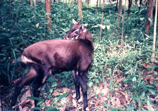
The wildlife of Vietnam is rich in flora and fauna as reflected by its unique biodiversity. Rare and endemic antelope-like animal, categorized under the bovine subfamily, was found in 1992, in Bạch Mã National Park. In the 1990s, three other large mammal species, the deer-like Truong Son muntjac, giant muntjac and Pu Hoat muntjac, were also discovered, the first two in the same park. Conservation protection and scientific studies of the ecology of Vietnam, particularly in the protected forest areas, have been given priority attention by the Government of Vietnam. Laws were enacted to set up Xuân Thủy Wetland National Park, four UNESCO Biosphere Reserves, and Hạ Long Bay and Phong Nha-Kẻ Bàng National Parks; the last two are also designated as UNESCO World Heritage Sites.

The Green Corridor of Vietnam is the international and national project name for one of the last remaining lowland wet evergreen forests, and supports significant populations of threatened species. It is located in Thừa Thiên–Huế Province, and is also part of Vietnam's Annamite Mountain Range. The area includes some of the longest remaining stretches of lowland river with intact forest habitat in Vietnam, which feed into the Perfume River. The rainforests of the Central Annamites likely existed as continuous undisturbed forest cover for thousands of years, and, as a result, offer unique habitats for many species. The name "Green Corridor" originates in preparatory project documents of the WWF.

Kon Ka Kinh National Park is a national park of Vietnam, established by the decision (167/2002/QĐ-TTg) on November 25, 2002 of the then Prime Minister, Phan Văn Khải.

Tsimanampetsotsa National Park national park of Madagascar

Tsimanampetsotsa National Park also spelt Tsimanampetsotse, and known as Tsimanampetsotsa Nature Reserve is a 432 km2 national park on the south-west coast of Madagascar in the region Atsimo-Andrefana. The park is 90 kilometres (56 mi) south of Toliara and 950 kilometres (590 mi) south of the capital, Antananarivo. Route Nationales (RN) 10 to Faux Cap passes the park and the nearest airport is at Toliara.

Bao Bolong Wetland Reserve protected area

Bao BolongWetland Reserve is a national park in The Gambia. Established in 1996 it covers 220 square kilometres.

Wasur National Park National park in Indonesia

The Wasur National Park forms part of the largest wetland in Papua province of Indonesia and has been one of the most disturbed by human activity. The high value of its biodiversity has led to the park being dubbed the "Serengeti of Papua". The vast open wetland, in particular Rawa Biru Lake, attracts a very rich fauna.

Stung Treng Dam

The Stung Treng Dam is a proposed hydroelectric dam on the Mekong River in Stung Treng Province, Cambodia. It would be located on the mainstream of the Lower Mekong River. The project is controversial for several reasons, including its possible impact on the fisheries, as well as other ecological and environmental factors.

Đồng Tháp Mười

Đồng Tháp Mười is an inland wetland in Vietnam's Mekong Delta. Most of the wetlands are within Long An Province and Đồng Tháp Province.

Protected areas of Vietnam

Many areas of Vietnam are under protection. While the national reserves cover small areas of scientific significance with restricted access, the national parks also cover wetlands of Ramsar designated areas and BirdLife International inscribed bird areas. The largest of the national parks initially covered were the Cúc Phương National Park, the Cát Tiên National Park, and the Côn Đảo National Park which to start with were forest areas cum reserves or prohibited areas. The objective for creating national parks was to allow access to the reserved areas as a part of ecotourism and cultural needs with full attention to the basic approach of conservation of natural environmental resources.

Cheetham Wetlands

The Cheetham Wetlands are 420 hectares of artificial and natural lagoons, created on old salt works land on the western shores of Port Phillip Bay, Australia. The wetlands are approximately 20 kilometres (12 mi) southwest of Melbourne, and sit within the Municipal Councils of Hobsons Bay and Wyndham City.

Wildlife of Ukraine

Wildlife of Ukraine includes its diverse fauna and flora. The reported fauna includes forty-five thousand species including the areas of the Black Sea and the Sea of Azov. Protected areas consist of 33 Ramsar sites covering an area of 7,446.51 square kilometres (2,875.11 sq mi). Biosphere nature reserves and three national parks are all part of the GEF projects portfolio of conservation of biodiversity in the Danube Delta. Their vegetation pattern is Mixed Forest area, Forest-Steppe area, Steppe area, Ukrainian Carpathian Mountains and Crimean Mountains. Some of the protected areas which were reserves or parks are subsumed under the biosphere reserves.

Point Cook Coastal Park Protected area in Victoria, Australia

The Point Cook Coastal Park covers an area of 863 hectares and includes the Cheetham Wetlands. The park extends from the RAAF Williams Point Cook Base northeast along the coast to the Laverton creek which comprises its northern boundary. The park is approximately 20 kilometres (12 mi) from Melbourne in a southwesterly direction along Port Phillip Bay. The park is adjoined by the Point Cook Marine Sanctuary, which extends around the point to the south and the east. The northwestern boundary to the park is residential housing.

Argentine Espinal

The espinal (NT0801) is an ecoregion of dry, thorny forest, savanna and steppe in Argentina. It has been extensively modified by large scale cattle ranching, but remnants of the original flora remain. It is threatened by the advance of the irrigation-based agricultural frontier.

References

  1. "Lang Sen Wetland Reserve". Ramsar Sites Information Service. Retrieved 25 April 2018.
  2. The Ramsar Convention on Wetlands
  3. http://www.wwf.org.uk/wwf_articles.cfm?unewsid=5518 Wild Mekong: new species discovered every two days