Charente-Maritime is a department in the Nouvelle-Aquitaine region on the southwestern coast of France. Named after the river Charente, its prefecture is La Rochelle. As of 2016, it had a population of 642,191 with an area of 6,864 square kilometres.

Gironde is a department in the Nouvelle-Aquitaine region of Southwestern France. Named after the Gironde estuary, a major waterway, its prefecture is Bordeaux. In 2016, it had a population of 1,566,679. The famous Bordeaux wine region is in Gironde. It has 6 arondissements, making it the department with the most arrondissements.

The Gironde estuary is a navigable estuary in southwest France and is formed from the meeting of the rivers Dordogne and Garonne just downstream of the centre of Bordeaux. Covering around 635 km2 (245 sq mi), it is the largest estuary in western Europe.

Royan is a commune and town in the south-west of France, in the department of Charente-Maritime in the Nouvelle-Aquitaine region. Its inhabitants are known as Royannais and Royannaises. Capital of the Côte de Beauté, Royan is one of the main French Atlantic coastal resort towns, and has five beaches, a marina for over 1,000 boats, and an active fishing port. As of 2013, the population of the greater urban area was 48,982. The town had 18,393 inhabitants in 2015.

The Pointe de Grave is the northernmost tip of the Médoc Peninsula and marks the Northern end of the pine-clad sandy Landes coastline of Western France. It lies in the commune of Le Verdon-sur-Mer and across the Gironde Estuary from the resort town of Royan.

Talmont-sur-Gironde is a commune in the Charente-Maritime department in the Nouvelle-Aquitaine region in southwestern France.

Arces, commonly identified under the name Arces-sur-Gironde, is a commune in the Charente-Maritime department in southwestern France. Its residents are referred to as Arcillons or Arcillonnes.

Barzan is a commune in the Charente-Maritime department in the Nouvelle-Aquitaine region of south-western France.

Rivedoux-Plage is a commune in the Charente-Maritime department in southwestern France. It is situated on the Île de Ré.

La Tremblade is a commune in the Charente-Maritime department and Nouvelle-Aquitaine region in south-western France.
La Jument is the name of a lighthouse at the Northwestern part of France, Brittany. The lighthouse is built on a rock about 300 metres from the coast of the island of Ushant, which marks the north-westernmost point of metropolitan France. There is also a very different lighthouse about 3 kilometres to the North, the Nividic lighthouse. Together with the Kreac'h lighthouse, they are the 3 most famous lighthouses of the region. It was listed as a historic monument in 2017.

Regnéville-sur-Mer is a commune in the Manche department in Normandy in north-western France.
La Vieille is a lighthouse in the département of Finistère at the commune of Plogoff, on the northwest coast of France. It lies on the rock known as Gorlebella, guiding mariners in the strait Raz de Sein, across from the companion lighthouse Tourelle de la Plate—also known as Petite Vieille. It is among the small class of lighthouses around the coasts of France carrying the moniker "hell", due to a remote position in rough seas.

Phare de Gatteville, also known as Pointe de Barfleur Light, is an active lighthouse near Gatteville-le-Phare at the tip of Barfleur, Manche department, in the Normandy region of France. At a height of 247 feet (75 m) it is the third tallest "traditional lighthouse" in the world.

The Forest of la Coubre is a large forest in the region of Nouvelle-Aquitaine, near the city of Royan. Its area is roughly 7916 hectares, making it the third largest forêt domaniale of the north of the region, behind forest of la Double and the forest d'Horte.

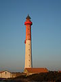
The Côte de Beauté is a part of the south-western coastline of France, situated south of the peninsula of Arvert, in the department of Charente-Maritime. Its capital is the town of Royan.

Nouvelle-Aquitaine or New Aquitaine, is the largest administrative region in France, spanning the west and southwest of the mainland. The region was created by the territorial reform of French regions in 2014 through the merger of three regions: Aquitaine, Limousin and Poitou-Charentes. It covers 84,036 km2 (32,446 sq mi) – or 1⁄8 of the country – and has 5,956,978 inhabitants. The new region was established on 1 January 2016, following the regional elections in December 2015.
The Gironde estuary and Pertuis sea Marine Nature Park is a protected area on the Gironde estuary and on the Atlantic coast of the departments Vendée, Charente-Maritime and Gironde, in western France. It was created in April 2015.

The Île Sans Nom, also known as the Île Mystérieuse or Tahiti, is an island in the Gironde estuary in south-west France. It appeared after the 2009 Cyclone Klaus led to increased deposition of sediment and lies near the historic Cordouan Lighthouse. It is regarded as an important emerging ecosystem and efforts have been made to protect the island from human intrusion. Officially it lies within the department of Gironde but in 2015 was occupied by a group claiming it for Charente-Maritime.
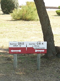
The sentier de Grande Randonnée 8, or GR 8 for short, is a long distance hiking trail on the French Atlantic coast. It is part of the Grande Randonnée network and runs from Saint-Brevin-les-Pins on the south of the Loire estuary, opposite the large port city of Saint-Nazaire and currently terminates at Sare in the Atlantic Pyrenees.