La Grande Béroche

Last updated • 4 min readFrom Wikipedia, The Free Encyclopedia
La Grande Béroche
Chateau de Gorgier2.jpg
Gorgier Castle above Gorgier village
LaGrandeBeroche-blazon.svg
Location of La Grande Béroche
La Grande Beroche
Switzerland adm location map.svg
Red pog.svg
La Grande Béroche
Reliefkarte Neuenburg blank.png
Red pog.svg
La Grande Béroche
Coordinates: 46°54′N6°47′E / 46.900°N 6.783°E / 46.900; 6.783
Country Switzerland
Canton Neuchâtel
Area
  Total42.21 km2 (16.30 sq mi)
Population
 (31 December 2018) [1]
  Total8,852
  Density210/km2 (540/sq mi)
Time zone UTC+01:00 (Central European Time)
  Summer (DST) UTC+02:00 (Central European Summer Time)
Postal code(s)
2022-24, 2027-28
SFOS number 6417
Surrounded by Autavaux (FR), Boudry, Estavayer-le-Lac (FR), Forel (FR), Noiraigue, Provence (VD), Saint-Aubin-Sauges, Travers
Website https://www.lagrandeberoche.ch/
SFSO statistics

La Grande Béroche is a municipality in the canton of Neuchâtel in Switzerland. On 1 January 2018 the former municipalities of Bevaix, Fresens, Gorgier, Montalchez, Saint-Aubin-Sauges and Vaumarcus merged to form the new municipality. [2]

Contents

History

Bevaix

Bevaix is first mentioned in 998 as in villa Bevacensi. In 1139 it was mentioned as Betuaci. [3]

Fresens

Fresens is first mentioned in 1265 as Hiremanz dit de Fressen. [4]

Gorgier

Gorgier is first mentioned in 1252 as de Corgie. [5]

Saint-Aubin-Sauges

Saint-Aubin-Sauges is first mentioned in 1176 as Sancti Albini. In 1340 it was mentioned as villa de Sauges. [6]

Vaumarcus

Vaumarcus was first mentioned in 1227 as Valmarcuel. [7]

It was created in 1875 as a merger of Vaumarcus and Vernéaz, and was called Vaumarcus-Vernéaz until 1966.

Montalchez

Montalchez is first mentioned in 1340 as villa de Montallichie. [8]

Geography

After the merger, La Grande Béroche has an area, as of 2009, of 42.25 km2 (16.31 sq mi). [9]

It was part of the district of Boudry until the district level was eliminated on 1 January 2018. [10]

Demographics

The new municipality has a population (as of December 2020) of 14,286. [11]

Historic Population

The historical population is given in the following chart: [12]

La Grande Beroche

Heritage sites of national significance

The prehistoric lake shore settlement at Baie De Bevaix, the neolithic funerary and cultural center of Treytel-A Sugiez in Bevaix, Gorgier Castle, the Gallo-Roman settlement at La Béroche and a prehistoric lake shore settlement in Gorgier, La Béroche, a Gallo-Roman settlement, and the neolithic settlement at Port Conty / Tivoli in Saint-Aubin-Sauges, the La Redoute Des Bourguignons, a prehistoric site and hallstatt tumulus in Vaumarcus are all listed as Swiss heritage site of national significance. [13]

World heritage site

The new municipality is home to three prehistoric sites which are part of the Prehistoric Pile dwellings around the Alps UNESCO World Heritage Site. Bevaix is home to the L’Abbaye 2 site, Gorgier has the Les Argilliez site and Saint-Aubin-Sauges has the Port-Conty site each of which is a prehistoric pile-dwelling (or stilt house) settlement. [14]

L'Abbaye 2 is a Bronze Age submerged site located near the L'Abbaye 1 Neolithic site. The former village at L'Abbaye 2 is about 180 meters (590 ft) from the lake shore and consisted of a number of stilt houses. It has been dendrochronologically dated to 1040-986 BC. The village site covers an area of about 150 by 80 m (490 by 260 ft) and was probably connected to the shore by a foot bridge. About 400 Bronze Age objects have been discovered in the water around the village. [15]

The Les Argilliez site consists of two villages. One is a Classical Cortaillod village with 6 piles dated between 3841 and 3817 BC. The other is a Late Cortaillod site with 2 piles from 3531 to 3528 BC. Both villages are in a small bay about 200 m (660 ft) north of the Chez-le-Bart 1 site. The remains of the villages are still quite visible underwater and stretch over an area of about 150 m × 50 m (490 ft × 160 ft). Some stone axes, antler ax handles and pottery fragments have been discovered. [15]

Port-Conty has two neolithic settlements. The first is a Late Cortaillod or Port-Conty type Cortaillod village. One piece of timber from this site has been dated to 3574. The second village is a Late Horgen village. Five of the piles are from 3160 and 3159, and two piles are from 3064 and 3062. The site was discovered in 1860 by F. Troyon, who originally thought it was a Bronze Age village. Further excavations in the late 19th and early 20th century found that it was a neolithic site. In 1929-1932, P. Vouga dug a long (55 m [180 ft]) 1 to 1.5 m (3.3 to 4.9 ft) deep trench to examine a single layer. He found three archaeological horizons which were from the Middle Neolithic, the Late Neolithic and the end of the Late Neolithic. Based on his study, it appears that the site was covered by an artificial mound which was 20 m × 10 m (66 ft × 33 ft) and about 70 cm (2 ft 4 in) deep. It was built in two stages, with a layer of branches between the layers. [15]

Related Research Articles

<span class="mw-page-title-main">Lake Neuchâtel</span> Lake in Switzerland

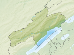
Lake Neuchâtel is a lake primarily in Romandy, the French-speaking part of Switzerland. The lake lies mainly in the canton of Neuchâtel, but is also shared by the cantons of Vaud, Fribourg, and Bern. It comprises one of the lakes in the Three Lakes Region, along with lakes Biel/Bienne and Morat/Murten.

<span class="mw-page-title-main">Murten</span> Municipality in Fribourg, Switzerland

Murten or Morat is a bilingual municipality and a city in the See district of the canton of Fribourg in Switzerland.

<span class="mw-page-title-main">Boudry</span> Municipality in Neuchâtel, Switzerland

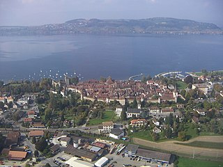
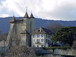
Boudry is a municipality in the canton of Neuchâtel in Switzerland.

<span class="mw-page-title-main">Cortaillod</span> Municipality in Neuchâtel, Switzerland

Cortaillod is a municipality in the canton of Neuchâtel in Switzerland.

Montalchez is a former municipality in the district of Boudry in the canton of Neuchâtel in Switzerland. On 1 January 2018 the former municipalities of Bevaix, Saint-Aubin-Sauges, Gorgier, Vaumarcus, Montalchez and Fresens merged into the new municipality of La Grande-Béroche.

<span class="mw-page-title-main">Gorgier</span> Former municipality in Neuchâtel, Switzerland

Gorgier is a former municipality in the district of Boudry in the canton of Neuchâtel in Switzerland. On 1 January 2018 the former municipalities of Bevaix, Saint-Aubin-Sauges, Gorgier, Vaumarcus, Montalchez and Fresens merged into the new municipality of La Grande-Béroche.

Bevaix is a former municipality in the district of Boudry in the canton of Neuchâtel in Switzerland. On 1 January 2018 the former municipalities of Bevaix, Saint-Aubin-Sauges, Gorgier, Vaumarcus, Montalchez and Fresens merged into the new municipality of La Grande-Béroche.

Fresens is a former municipality in the district of Boudry in the canton of Neuchâtel in Switzerland. On 1 January 2018 the former municipalities of Bevaix, Saint-Aubin-Sauges, Gorgier, Vaumarcus, Montalchez and Fresens merged into the new municipality of La Grande-Béroche.

Saint-Aubin-Sauges is a former municipality in the district of Boudry in the canton of Neuchâtel in Switzerland. On 1 January 2018 the former municipalities of Bevaix, Saint-Aubin-Sauges, Gorgier, Vaumarcus, Montalchez and Fresens merged into the new municipality of La Grande-Béroche.

<span class="mw-page-title-main">Vaumarcus</span> Former municipality in Neuchâtel, Switzerland

Vaumarcus is a former municipality in the district of Boudry in the canton of Neuchâtel in Switzerland. On 1 January 2018 the former municipalities of Bevaix, Saint-Aubin-Sauges, Gorgier, Vaumarcus, Montalchez and Fresens merged into the new municipality of La Grande-Béroche.

Boudry District was one of the six districts of the canton of Neuchâtel, Switzerland, until the district level was eliminated on 1 January 2018. It had a population of 40,701. The district capital was the town of Boudry.

<span class="mw-page-title-main">Wartau</span> Municipality in St. Gallen, Switzerland

Wartau is a municipality in the Werdenberg constituency of the Swiss canton of St. Gallen. The municipality consists of a number of villages on the eastern flank of the Alvier group, along the left shore of the Alpine Rhine.

<span class="mw-page-title-main">Haut-Vully</span> Former municipality in Fribourg, Switzerland

Haut-Vully is a former municipality in the district of See/Lac in the canton of Fribourg in Switzerland. Until 1977, it was officially known as Vully-Le-Haut. Its German name of Oberwistenlach is now little used. On 1 January 2016 the former municipalities of Bas-Vully and Haut-Vully merged to form Mont-Vully.

<span class="mw-page-title-main">Kempraten</span> Former municipality of Switzerland in St. Gallen

Kempraten-Lenggis is a village (Kirchdorf) within the municipality of Rapperswil-Jona, Wahlkreis (constituency) of See-Gaster in the canton of St. Gallen in Switzerland. The remains of the Gallo-Roman settlement Centum Prata are one of the most important archaeological sites in the canton of St. Gallen; Centrum Prata is located at the so-called Kempratnerbucht, in Rapperswil and Busskirch on Zürichsee lake shore.

<span class="mw-page-title-main">Twann-Tüscherz</span> Municipality in Bern, Switzerland

Twann-Tüscherz or Douanne-Daucher in French is a municipality in the Biel/Bienne administrative district in the canton of Bern in Switzerland. On 1 January 2010 the municipalities of Tüscherz-Alfermée and Twann merged into the municipality of Twann-Tüscherz.

<span class="mw-page-title-main">Prehistoric pile dwellings around the Alps</span> Prehistoric pile dwelling settlements around the Alps

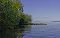
Prehistoric pile dwellings around the Alps are a series of prehistoric pile dwelling settlements in and around the Alps built from about 5000 to 500 BC on the edges of lakes, rivers or wetlands. In 2011, 111 sites located variously in Switzerland (56), Italy (19), Germany (18), France (11), Austria (5) and Slovenia (2) were added to the UNESCO World Heritage Site list. In Slovenia, these were the first World Heritage Sites to be listed for their cultural value.

Milvignes is a municipality in the canton of Neuchâtel in Switzerland. It was formed on January 1, 2013, by merging the former municipalities Auvernier, Bôle and Colombier.

<span class="mw-page-title-main">Sauge</span> Municipality in Bern, Switzerland

Sauge is a municipality in the Jura bernois administrative district in the canton of Bern in Switzerland. It is located in the French-speaking Bernese Jura. On 1 January 2014 the former municipalities of Plagne and Vauffelin merged into the municipality of Sauge.

<span class="mw-page-title-main">Mont-Vully</span> Municipality in Fribourg, Switzerland

Mont-Vully is a municipality in the district of See in the Canton of Fribourg in Switzerland. It was formed on 1 January 2016 when the former municipalities of Bas-Vully and Haut-Vully merged.

<span class="mw-page-title-main">Hautemorges</span> Municipality in Vaud, Switzerland

Hautemorges is a municipality in the Swiss canton of Vaud, located in the district of Morges.

References

  1. "Ständige Wohnbevölkerung nach Staatsangehörigkeitskategorie Geschlecht und Gemeinde; Provisorische Jahresergebnisse; 2018". Federal Statistical Office. 9 April 2019. Retrieved 11 April 2019.
  2. Amtliches Gemeindeverzeichnis der Schweiz published by the Swiss Federal Statistical Office (in German) accessed 27 April 2016
  3. Bevaix in German , French and Italian in the online Historical Dictionary of Switzerland .
  4. Fresens in German , French and Italian in the online Historical Dictionary of Switzerland .
  5. Gorgier in German , French and Italian in the online Historical Dictionary of Switzerland .
  6. Saint-Aubin-Sauges in German , French and Italian in the online Historical Dictionary of Switzerland .
  7. Vaumarcus in German , French and Italian in the online Historical Dictionary of Switzerland .
  8. Montalchez in German , French and Italian in the online Historical Dictionary of Switzerland .
  9. Arealstatistik Standard - Gemeindedaten nach 4 Hauptbereichen
  10. Amtliches Gemeindeverzeichnis der Schweiz (in German) accessed 15 February 2018
  11. "Ständige und nichtständige Wohnbevölkerung nach institutionellen Gliederungen, Geburtsort und Staatsangehörigkeit". bfs.admin.ch (in German). Swiss Federal Statistical Office - STAT-TAB. 31 December 2020. Retrieved 21 September 2021.
  12. Swiss Federal Statistical Office STAT-TAB Bevölkerungsentwicklung nach institutionellen Gliederungen, 1850-2000 (in German) accessed 27 April 2016
  13. "Swiss inventory of cultural property of national and regional significance". A-Objects. Federal Office for Cultural Protection (BABS). 1 January 2017. Archived from the original on 2 September 2016. Retrieved 6 September 2017.
  14. UNESCO World Heritage Site - Prehistoric Pile dwellings around the Alps
  15. 1 2 3 Palafittes.org nominating documents-Volume II: Id-files of the component parts of the serial, section 2 Archived 2012-03-30 at the Wayback Machine accessed 18 October 2011