La Grange Mine

Last updated
La Grange Mine
Location Trinity County, California;
Along California State Route 299, about 4 miles (6.4 km) west of Weaverville, California
Founded 1862
Demolished 1918 (closed)
Designated 1962 [1]
Reference no. 778

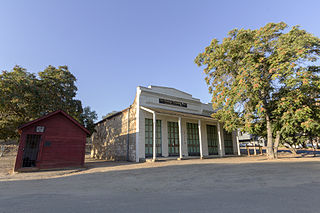
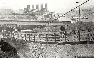
The La Grange Mine is a former mine located in Trinity County, California. At one time it was the largest hydraulic mine in California. Started operating in 1862, over 3,500,000 dollars of gold was extracted before it was closed down in 1918 due to rising costs of labor and steel after World War I. The quality of gold was low so hydraulic mining was used to take it from the ground. The site is now a California Historical Landmark. [1] [2] [3]

Trinity County, California County in California, United States

Trinity County is a county in the northwestern part of the state of California. As of the 2010 census, the population was 13,786, making it the fourth least-populous county in California. The county seat and largest community is Weaverville.

California State of the United States of America

California is a state in the Pacific Region of the United States. With 39.6 million residents, California is the most populous U.S. state and the third-largest by area. The state capital is Sacramento. The Greater Los Angeles Area and the San Francisco Bay Area are the nation's second and fifth most populous urban regions, with 18.7 million and 9.7 million residents respectively. Los Angeles is California's most populous city, and the country's second most populous, after New York City. California also has the nation's most populous county, Los Angeles County, and its largest county by area, San Bernardino County. The City and County of San Francisco is both the country's second-most densely populated major city after New York City and the fifth-most densely populated county, behind only four of the five New York City boroughs.

World War I 1914–1918 global war originating in Europe

World War I, also known as the First World War or the Great War, was a global war originating in Europe that lasted from 28 July 1914 to 11 November 1918. Contemporaneously described as "the war to end all wars", it led to the mobilisation of more than 70 million military personnel, including 60 million Europeans, making it one of the largest wars in history. It is also one of the deadliest conflicts in history, with an estimated nine million combatants and seven million civilian deaths as a direct result of the war, while resulting genocides and the 1918 influenza pandemic caused another 50 to 100 million deaths worldwide.

Contents

The name comes from the owner who bought it in 1893, the French baron Ernest de la Grange. He came from North of France with his wife (Clémentine de Chaumont Quitry) and his two children (Emilie and Amaury de la Grange)

Coordinates: 40°44′28″N122°59′26″W / 40.74111°N 122.99056°W / 40.74111; -122.99056 [4]

Geographic coordinate system Coordinate system

A geographic coordinate system is a coordinate system that enables every location on Earth to be specified by a set of numbers, letters or symbols. The coordinates are often chosen such that one of the numbers represents a vertical position and two or three of the numbers represent a horizontal position; alternatively, a geographic position may be expressed in a combined three-dimensional Cartesian vector. A common choice of coordinates is latitude, longitude and elevation. To specify a location on a plane requires a map projection.

See also

This list includes properties and districts listed on the California Historical Landmark listing in Trinity County, California. Click the "Map of all coordinates" link to the right to view a Google map of all properties and districts with latitude and longitude coordinates in the table below.

Related Research Articles

Nevada County, California County in California, United States

Nevada County is a county in the Sierra Nevada of California. As of the 2010 census, the population was 98,764. The county seat is Nevada City.

Hydraulic mining A mining technique using high-pressure jets of water to carve away minerals

Hydraulic mining, or hydraulicking, is a form of mining that uses high-pressure jets of water to dislodge rock material or move sediment. In the placer mining of gold or tin, the resulting water-sediment slurry is directed through sluice boxes to remove the gold. It is also used in mining kaolin and coal.

Gold Country

The Gold Country is a historic region in the northern portion of the U.S. State of California, that is primarily on the western slope of the Sierra Nevada. It is famed for the mineral deposits and gold mines that attracted waves of immigrants, known as the 49ers, during the 1849 California Gold Rush.

Dog Town, California Ghost town in California, United States

Dog Town is a ghost town in Mono County, California. Today, Dog Town is a defunct gold rush era town in Mono County, California. It is located at 38°10′13″N119°11′51″W, on Dog Creek, near the junction of Clearwater and Virginia Creeks, about 6 miles (10 km) south-southeast of Bridgeport, at an elevation of 7057 feet.

Picacho, California Unincorporated community in California, United States

Picacho is an unincorporated community in Imperial County, California. It is located on the Colorado River 29 miles (47 km) south-southeast of Palo Verde, at an elevation of 203 feet.

French Corral, California Unincorporated community in California, United States

French Corral is an unincorporated community approximately five miles west of California State Highway 49 in Nevada County, California.

La Grange, California Unincorporated community in California, United States

La Grange is a small unincorporated community in rural Stanislaus County, California, United States. Its altitude is 249 feet (76 m). As of 2008 it has a population of 345. It is located at 37°39′49″N120°27′49″W along the Tuolumne River, and is near the La Grange Dam and the New Don Pedro Dam.

Timbuctoo, California Unincorporated community in California, United States

Timbuctoo is an unincorporated community in Yuba County, California. It lies northwest of Smartsville, at an elevation of 397 feet.

French Lake, California, located in Nevada County, was a California Gold Rush community, now uninhabited. It was located by a lake of the same name.

North Bloomfield Mining and Gravel Company

The North Bloomfield Mining and Gravel Company of North Bloomfield, California, was established in 1866 and operated a hydraulic gold-mining operation at the Malakoff Mine subsequent to the California Gold Rush. In its day, no other company's operations matched North Bloomfield Mining and Gravel Company in size or expense.

Kennett, California human settlement in United States of America

Kennett was an important copper mining town in northern California, United States until it was flooded by Shasta Lake while Shasta Dam was being constructed. Kennett is submerged under approximately 400 ft. of water. It was the largest, most important mining town in the area outside of Redding and Shasta.

Giant was an unincorporated community, now within Point Pinole Regional Shoreline, and annexed to Richmond in Contra Costa County, California. It lies at an elevation of 23 feet.

Blue Tent, California Mining community in California, United States

Blue Tent is a historic 19th century gold mining community located about six miles northeast of Nevada City, California.

Cherokee, Nevada County, California Former settlement in California, United States

Cherokee is a former gold mining community in Nevada County, California. As explained below, it has also been known as Patterson, Melrose and Tyler. It is located on the San Juan Ridge about 4 miles east of North San Juan. Its elevation is 2,516 ft (767 m) above sea level.

Red Dog, California Former settlement in California, United States

Red Dog was a California gold rush mining town located in the Gold Country in south-central Nevada County, California, United States, 6 mi (9.7 km) northeast of Chicago Park. Red Dog Hill, a mine and campsite, was founded by three men all under the age of 22, and was named by their youngest, a 15-year-old prospector. As mining operations grew, the campsite became a settlement, and then a town with a population of 2,000 residents, before it was eventually abandoned. Still considered important today, Red Dog Townsite is listed on the National Register of Historic Places. Red Dog has been noted for its unusual place name.

Gold Run, California Former settlement in California, United States

Gold Run was a former mining town of the California Gold Rush, located in Placer County, California.

Rancho Temescal was a Mexican land grant in present-day Temescal Valley in Riverside County, California, granted by Governor José María de Echeandía in 1828 to Leandro Serrano.

North Star Mine and Powerhouse California gold mine

The North Star Mine and Powerhouse are located on Lafayette Hill a short distance south of Grass Valley in the U.S. state of California. It was the second largest producer of gold during California's Gold Rush. In 1898, the largest ever Pelton wheel for its time was built for the mine. The North Star Mine Company also owned locations on Weimar Hill, adjoining and south of the North Star Mine. It shut down during World War II after its consolidation with the Empire Mine.

Carbondale, in Orange County, California, is a historical coal mining town in Santiago Canyon, where Santiago Creek had its confluence with Silverado Creek. It had a post office from May 11, 1881, to January 29, 1884, when it was closed and mail sent to the Santa Ana post office.

Hooperville, a former gold mining camp, near Fort Jones in the 1850s in Siskiyou County, California. Its site lies at an elevation of 3054 feet,. The village site is on Indian Creek road, and Schoolhouse Gap fort jones ca. There are a few mines left(private) and the obvious remains of the stamp mill footings.

References