
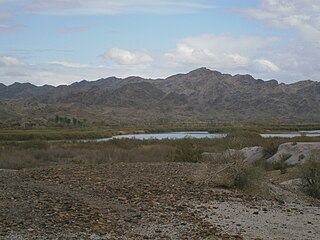
Mittry Lake is located in the Mittry Lake Wildlife Area, just north of Yuma, Arizona, on the Lower Colorado River. It is located in between the upstream Imperial Dam and the downstream Laguna Dam. Mittry Lake comprises about 750 acres (300 ha), with much of the shoreline covered with cattails and bullrush. The lake has undergone rehabilitation work including marsh dredging, revegetation and fish habitat improvement, making it a great location for small game hunting and sport fishing. It is public land managed by the Arizona Game and Fish Department, the Bureau of Reclamation and the Bureau of Land Management, and available to the public for recreational purposes.

The Verde River is a major tributary of the Salt River in the U.S. state of Arizona. It is about 170 miles (270 km) long and carries a mean flow of 602 cubic feet per second (17.0 m3/s) at its mouth. It is one of the largest perennial streams in Arizona.

Lake Havasu is a large reservoir formed by Parker Dam on the Colorado River, on the border between San Bernardino County, California and La Paz County, Arizona. Lake Havasu City sits on the Arizona (eastern) side of the lake with its Californian counterpart of Havasu Lake directly across the lake. The reservoir has an available capacity of 619,400 acre feet (764,000,000 m3). The concrete arch dam was built by the United States Bureau of Reclamation between 1934 and 1938. The lake's primary purpose is to store water for pumping into two aqueducts. Prior to the dam construction, the area was home to the Mojave Indians. The lake was named after the Mojave word for blue. In the early 19th century, it was frequented by beaver trappers. Spaniards also began to mine the areas along the river.

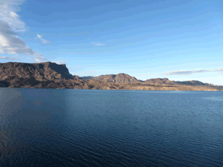
Cottonwood Cove is situated at the banks of Lake Mohave on the Nevada-Arizona border in Clark County, Nevada, United States. It stands just 13.1 miles and 23 minutes east of Searchlight, 12.5 miles north of Laughlin and an hour away from Las Vegas. It is the site of the Cottonwood Cove Resort and Marina. The cove is part of the Lake Mead National Recreation Area administered by the U.S. National Park Service. The desert lake is approximately 67 miles long and is backed by the Davis Dam on the Colorado River.

Buckskin Mountain State Park is a state park located near Parker, Arizona, USA. A second developed area of the park is known as the River Island Unit or River Island State Park. Both park areas have shoreline on the Colorado River and views of the Buckskin Mountains. The park provides camping and water recreation opportunities.
Show Low Lake is a 100-acre (0.40 km2) lake nestled at 6,500 feet (2,000 m) elevation in the White Mountains of Arizona which is administered by the Arizona Game and Fish Department along with the city of Show Low. Show Low Lake Park is located five miles (8 km) south of Show Low.
Picacho State Recreation Area is a camping, boating, and general recreation area located on a 9-mile stretch of the lower Colorado river at the site of Picacho, a defunct gold mining town.
Cattail Cove State Park is a state park of Arizona, USA, on the shore of Lake Havasu. The park is located on Arizona State Route 95 in far southern Mohave County, about 19 miles (31 km) from Lake Havasu City and 8 miles (13 km) from Parker Strip. The park is public land managed by the Arizona State Parks, and available to the public for recreational purposes.

The Bill Williams River is a 46.3-mile-long (74.5 km) river in west-central Arizona where it, along with its tributary, the Santa Maria River, form the boundary between Mohave County to the north and La Paz County to the south. It is a major drainage westwards into the Colorado River of the Lower Colorado River Valley south of Hoover Dam and Lake Mead, and the drainage basin covers portions of northwest, and west-central Arizona. The equivalent drainage system paralleling the east–west lower reaches of the Bill Williams is the Gila River, which flows east-to-west across central Arizona, joining the Colorado River in the southwest at Yuma. The confluence of the Bill Williams River with the Colorado is north of Parker, and south of Lake Havasu City.
Green Valley Lake is located in Payson, Arizona. Green Valley Lake is a reservoir connected to two smaller lakes in Green Valley Park. These lakes were constructed from 1993 to 1996 for ground water recharge.
Walter's Camp is a RV park and campground in the United States located on the California side of the Colorado River between Blythe, California and Yuma, Arizona, in Imperial County. Walter's Camp features RV hook-up sites, dry camping sites, boat ramp, store, bar, gas dock, picnic sites, and RV/boat storage.

Patagonia Lake is a man-made reservoir in Santa Cruz County, Arizona, United States, located southwest of the town of Patagonia, Arizona and northeast of Nogales. The lake was created by damming Sonoita Creek, and is a popular area for boating and sport fishing. Facilities are maintained by Arizona State Parks as part of Patagonia Lake State Park.

Roper Lake State Park is a state park of Arizona, surrounding 32-acre (130,000 m2) Roper Lake. The park is located off U.S. Route 191, 5 miles (8.0 km) south of Safford, at the Gila River and Valley.
Horsethief Basin Lake is a reservoir in the Bradshaw Mountains and the Prescott National Forest, in central Arizona. It is located near Crown King in eastern Yavapai County. Fish species present include Bluegill, Largemouth Bass, Channel Catfish, and Muskie.

Kennedy Lake is located in Tucson at J. F. Kennedy Park, north of Ajo Way between La Cholla Boulevard and Mission Road.
Gilmore's Camp is located on the California side of the Colorado River in Imperial County about half way between Blythe, California and Yuma, Arizona.

Fishers Landing is located along the Arizona side of the Colorado River in Yuma County.
Kiwanis Lake is located in Kiwanis Community Park in central Tempe, Arizona, United States, southwest of Baseline Road and Mill Avenue.
Cortez Lake is located in Cortez Park in northwest Phoenix, Arizona, United States, at the northeast corner of 35th Avenue and Dunlap Avenue.

This is a list of the National Register of Historic Places listings in La Paz County, Arizona.