Brussels, officially the Brussels-Capital Region, is a region of Belgium comprising 19 municipalities, including the City of Brussels, which is the capital of Belgium. The Brussels-Capital Region is located in the central portion of the country and is a part of both the French Community of Belgium and the Flemish Community, but is separate from the Flemish Region and the Walloon Region, located less than 4 kilometres (2.5 mi) to the south. Historically Dutch-speaking, Brussels saw a language shift to French from the late 19th century. Nowadays, the Brussels-Capital Region is officially bilingual in French and Dutch, although French is the majority language and lingua franca. Brussels is also increasingly becoming multilingual. English is spoken widely and many migrants and expatriates speak other languages as well.

Anderlecht is one of the 19 municipalities of the Brussels-Capital Region, Belgium. Located in the south-western part of the region, it is bordered by the City of Brussels, Forest, Molenbeek-Saint-Jean, and Saint-Gilles, as well as the Flemish municipalities of Dilbeek and Sint-Pieters-Leeuw. In common with all of Brussels' municipalities, it is legally bilingual (French–Dutch).

Etterbeek is one of the 19 municipalities of the Brussels-Capital Region, Belgium. Located in the eastern part of the region, it is bordered by the municipalities of Auderghem, the City of Brussels, Ixelles, Schaerbeek, Woluwe-Saint-Lambert and Woluwe-Saint-Pierre. In common with all of Brussels' municipalities, it is legally bilingual (French–Dutch).

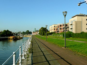
Molenbeek-Saint-Jean or Sint-Jans-Molenbeek, often simply called Molenbeek, is one of the 19 municipalities of the Brussels-Capital Region, Belgium. Located in the western part of the region, it is bordered by the City of Brussels, from which it is separated by the Brussels–Charleroi Canal, as well as by the municipalities of Anderlecht, Berchem-Sainte-Agathe, Dilbeek, Jette, and Koekelberg. The Molenbeek brook, from which it takes its name, flows through the municipality. In common with all of Brussels' municipalities, it is legally bilingual (French–Dutch).

Charleroi is a city and a municipality of Wallonia, located in the province of Hainaut, Belgium. The city is situated in the valley of the Sambre, in the south-west of Belgium, not far from the border with France. By 1 January 2008, the total population of Charleroi was 201,593. The metropolitan area, including the outer commuter zone, covers an area of 1,462 square kilometres (564 sq mi) with a total population of 522,522 by 1 January 2008, ranking it as the 5th most populous in Belgium after Brussels, Antwerp, Liège, and Ghent. The inhabitants are called Carolorégiens or simply Carolos.
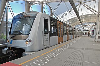
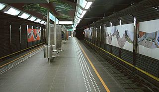
The Brussels Metro is a rapid transit system serving a large part of the Brussels-Capital Region of Belgium. It consists of four conventional metro lines and three premetro lines. The metro-grade lines are M1, M2, M5, and M6 with some shared sections, covering a total of 39.9 kilometres (24.8 mi), with 59 metro-only stations. The premetro network consists of three tram lines that partly travel over underground sections that were intended to be eventually converted into metro lines. Underground stations in the premetro network use the same design as metro stations. A few short underground tramway sections exist, so there is a total of 52.0 kilometres (32.3 mi) of underground metro and tram network. There are a total of 69 metro and premetro stations as of 2011.
Roue is a synonym for rake (character).

Saint-Gilles or Sint-Gillis is one of the 19 municipalities of the Brussels-Capital Region, Belgium. Located in the southern part of the region, it is bordered by the City of Brussels, Anderlecht, Forest and Ixelles. In common with all of Brussels' municipalities, it is legally bilingual (French–Dutch), but predominantly French-speaking nowadays.
Eddy Merckx is a Brussels Metro station on the western branch of line 5. It is located in the municipality of Anderlecht, in the western part of Brussels, Belgium. The station is named after the Belgian cyclist Eddy Merckx, five-times winner of the Tour de France. It is decorated with objects commemorating Merckx, including, displayed in a glass cabinet on the station platform, the bicycle on which he set the hour record in 1972.
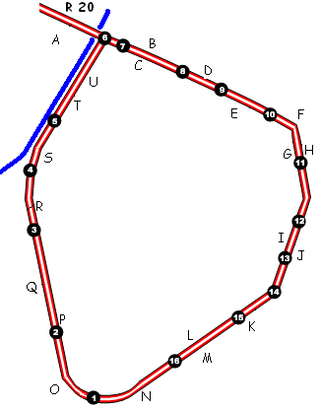
The Small Ring inner ring road, formally R20 and N0 is a series of roadways in central Brussels, Belgium, surrounding the historic city centre. The city centre is usually defined as the area within the Small Ring; this area is called the Pentagon due to its pentagonal shape. The pentagon forms the core of the City of Brussels municipality.
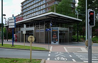
Erasme (French) or Erasmus (Dutch) metro station is the western terminus of line 5 on the Brussels Metro. It is located in the municipality of Anderlecht, in the western part of Brussels, Belgium. The station was designed by Philippe Samyn and Partners and is named after Erasmus Hospital, which it serves. It lies at grade and has a single island platform, which can be reached through tunnels under the tracks.

CERIA (French) or COOVI (Dutch) is a Brussels Metro station on the western branch of line 5. It is located in the municipality of Anderlecht, in the western part of Brussels, Belgium. The station serves the Food and Chemical Industries Education and Research Center (CERIA/COOVI), after which it is named.
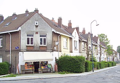
La Roue (French) or Het Rad (Dutch) is a Brussels Metro station on the western branch of line 5. It is located in the municipality of Anderlecht, in the western part of Brussels, Belgium. The station serves the La Roue/Het Rad district, after which it is named.
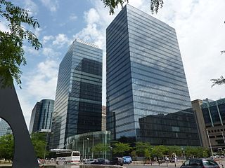
The Northern Quarter is the central business district of Brussels, Belgium. Like La Défense in Paris, the Docklands in London or the Zuidas in Amsterdam, the Northern Quarter consists of a concentrated collection of high-rise buildings where many Belgian and multinational companies have their headquarters.

The Belgian railway line 50 is a railway line in Belgium connecting Brussels to Ghent. The first section between Ghent and Schellebelle was finished in 1837, offering a connection to Brussels through Dendermonde and Mechelen. The section between Schellebelle and Brussels was completed on 1 May 1856.

Woluwe-Saint-Lambert or Sint-Lambrechts-Woluwe is one of the 19 municipalities of the Brussels-Capital Region, Belgium. In common with all of Brussels' municipalities, it is legally bilingual (French–Dutch). In French, it is often spelt Woluwé-Saint-Lambert to reflect the Frenchified pronunciation of what was originally a Dutch place name, but the official spelling is without an accent. The Woluwe stream, from which it takes its name, flows through the municipality.

The following is a timeline of the history of Brussels, Belgium.

The Place de la Vaillance, meaning "Valour Square", is the main square located in the historical centre of the Brussels municipality of Anderlecht, Belgium. It is served by Saint Guidon/Sint Guido metro station on line 5 of the Brussels Metro.

Scheut is a district of Anderlecht, a municipality of Brussels, Belgium. Located in the north of Anderlecht, it is bounded by the border with the municipality of Molenbeek-Saint-Jean to the north, the historical centre of Anderlecht to the south, the Birmingham district to the east, the Scheutveld district to the west and the semi-natural site of the Scheutbos to the north-west.

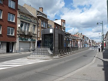
Cureghem (French) or Kuregem (Dutch) is a district of Anderlecht, a municipality of Brussels, Belgium. Located in the east of Anderlecht, it is one of this municipality's largest and most populated districts. It developed during the Industrial Revolution along the Brussels–Charleroi Canal and is currently in a fragile social and economic situation due to the decline of its economy and the poor quality of some of its housing.