Sants is a neighborhood in the southern part of Barcelona, Catalonia, Spain. Formerly an industrial town on the plain bordering Barcelona, known as Santa Maria de Sants, it belongs nowadays to the district of Sants-Montjuïc and is bordered by the districts of Eixample to the northeast, Les Corts to the northwest, and by the municipality of l'Hospitalet de Llobregat to the south. Although old-fashioned, its name is sometimes still written Sans in some Spanish-language sources. Its neighborhood boss and mayor is Francesc Lara.
L'Antiga Esquerra de l'Eixample is a neighborhood in the Eixample district of Barcelona, Catalonia (Spain). Originally formed a single unit, called Esquerra de l'Eixample, with the current neighborhood la Nova Esquerra de l'Eixample.

Dreta de l'Eixample is a neighborhood in the Eixample district of Barcelona, Catalonia (Spain). It is located east of Carrer de Balmes. It includes Plaça de Catalunya, the centre of the city, and the upscale streets Rambla de Catalunya and Passeig de Gràcia. It is the bourgeois neighborhood of the city, which makes the majority of its population belong to the upper class of Barcelona. Dreta de L'Eixample is one of the most luxurious neighbors of Barcelona.

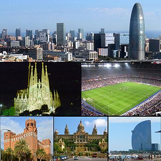
Sagrada Família is a neighborhood in the Eixample district of Barcelona, Catalonia (Spain). Its name comes from the church of the Sagrada Família, work of Antoni Gaudí, which can be found in the center of the neighborhood.

Vila de Gràcia, also known as Gràcia, is a neighborhood in the Gràcia district of Barcelona, Catalonia (Spain). This neighborhood was the main core of the old town of Gràcia that included also Camp d'en Grassot i Gràcia Nova.
Les Corts is a neighborhood in the les Corts district of Barcelona, Catalonia (Spain).

La Vila Olímpica del Poblenou is a neighborhood in the Sant Martí district of Barcelona, Catalonia (Spain). It was constructed in the late 1980s and early 1990s for the 1992 Summer Olympic Games which took place in Barcelona. Its construction was devised by Oriol Bohigas, David Mackay and Albert Puigdomènec as a residential area in the otherwise industrial and working-class district of Poblenou, which underwent regeneration but involved massive expropriation, as well as the destruction of a sizeable portion of the district, including Industrial Revolution factories of architectural value such as Fàbrica Foret. It follows essentially the reticular outline of Eixample and Poblenou, with about 2000 new apartments in the area, owned by the mixed public-private company VOSA.

El Besòs i el Maresme is a neighborhood in the Sant Martí district of Barcelona, Catalonia (Spain). Originally the land had been irrigated by the irrigation of the burrow and the Verneda, remains of an old arm of the river Besòs that empties into the Camp de la Bóta. The neighborhood stretches along the Rambla de Prim.
Les Roquetes is a neighborhood in the Nou Barris district of the city of Barcelona, Catalonia, Spain.
La Trinitat Nova is a neighborhood in the Nou Barris district of Barcelona, Catalonia, Spain.

La Clota is a neighborhood in the Horta-Guinardó district of Barcelona, Catalonia (Spain).

Montbau is a neighborhood in the Horta-Guinardó district of the city of Barcelona, Catalonia, Spain.

Vall d'Hebron is a neighborhood in the Horta-Guinardó district of Barcelona, Catalonia, Spain.

Sant Gervasi – la Bonanova is a neighborhood in the Sarrià-Sant Gervasi district of Barcelona, Catalonia (Spain). Formerly it was with the neighborhood of Sant Gervasi - Galvany, an independent municipality called Sant Gervasi de Cassoles.
Sarrià is a neighborhood in the Sarrià-Sant Gervasi district of Barcelona, Catalonia. Its main street is Major de Sarrià.
La Bordeta is a neighborhood in the Sants-Montjuïc district of Barcelona, Catalonia (Spain). It is located between Sants and l'Hospitalet de Llobregat. The neighborhood was in the bottom of the former municipality of Sants.
La Marina del Prat Vermell is a neighborhood in the Sants-Montjuïc district of Barcelona, Catalonia (Spain). The name comes from fields that occupied this area of low part of la Marina de Sants. This is a new neighborhood that is developing between the other sector of la Marina de Sants, la Marina de Port, and the industrial area of Zona Franca.

El Poble-sec is a neighborhood in the Sants-Montjuïc district of Barcelona, Catalonia (Spain). The neighborhood is located between Montjuïc mountain and the Avinguda del Paral·lel.

Sants-Badal is a neighborhood in the Sants-Montjuïc district of Barcelona, Catalonia (Spain). It belonged to the former municipality of Sants, current district of Sants-Montjuïc. Extending 0,41 km² and with a population of 24,507 it is the most densely populated neighborhood in the city with a density of 59,685/km².

Sant Sebastià beach is located in Barcelona, Catalonia, Spain. At 1,100 meters, it is the longest in Barcelona. This is a sandy beach in the Barceloneta neighborhood of Ciutat Vella district.