Districts of Barcelona

Last updated
The city's ten districts. Barcelona districtes.svg
The city's ten districts.

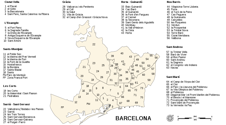
Barcelona , Catalonia, Spain is divided into 10 districts. These are administered by a councillor designated by the main city council, and each of them have some powers relating to issues such as urbanism or infrastructure in their area. The current division of the city into different districts was approved in 1984. [1] In 2009 Barcelona started using a new division of 73 neighbourhoods (the 10 districts are still in use), a division that was done for a better service from the City Council. [1]

Contents

Some of these districts have a previous history as independent municipalities which were integrated into the city of Barcelona during the late 19th century and the first half of the 20th century, such as Sarrià, Les Corts, Sant Andreu de Palomar, Gràcia or Sant Martí de Provençals. However, other municipalities which are contiguous to Barcelona (such as L'Hospitalet de Llobregat, Badalona, Sant Adrià de Besòs or Montcada i Reixac) have remained separate towns to this day, and are part of the much larger metropolitan area of Barcelona.

Districts and neighbourhoods of Barcelone (2021)
Nº.DistrictLocationSize km² [2] Population [3] Density inhabitants/km²Neighbourhoods [4]
NamePopulationSize
(ha)
1 Old City Barcelona districte I.svg 4.11109,67226,684.21 El Raval 48,688110
2 El Gòtic 22,85081.6
3 La Barceloneta 15,125109.5
4 Sant Pere, Santa Caterina i la Ribera 23,009111
2 Eixample Barcelona districte II.svg 7.46269,34936,105.85 Fort Pienc 33,44592.9
6 Sagrada Família 52,164104.2
7 Dreta de l'Eixample 44,088212
8 L'Antiga Esquerra de l'Eixample 43,046122.8
9 La Nova Esquerra de l'Eixample 57,906134.1
10 Sant Antoni 38,70080.4
3 Sants-Montjuïc Barcelona districte III.svg 22.68187,0268,246.311 Poble-sec 40,204458.5
12 la Marina del Prat Vermell 1,3561,403.4
13 la Marina de Port 31,092126.9
14 la Font de la Guatlla 10,23929.7
15 Hostafrancs 16,10241
16 la Bordeta 19,45157.2
17 Sants-Badal 24,90341.5
18 Sants 43,679109.5
4 Les Corts Barcelona districte IV.svg 6.0281,57613,550.819 les Corts 45,943141
20 la Maternitat i Sant Ramon 23,825191.5
21 Pedralbes 11,808268.5
5 Sarrià-Sant Gervasi Barcelona districte V.svg 19.91149,2017,493.822 Vallvidrera, el Tibidabo i les Planes 4,7601,132.9
23 Sarrià 24,769304.7
24 les Tres Torres 16,35678.8
25 Sant Gervasi - la Bonanova 25,984223.4
26 Sant Gervasi - Galvany 47,346166.9
27 el Putget i Farró 29,98684.8
6 Gràcia Barcelona districte VI.svg 4.19123,27629,421.528 Vallcarca i els Penitents 16,325125.1
29 el Coll 7,68835.3
30 la Salut 13,45564.8
31 Vila de Gràcia 50,456132.1
32 Camp d'en Grassot i Gràcia Nova 35,35265.1
7 Horta-Guinardó Barcelona districte VII.svg 11.96173,94414,543.833 el Baix Guinardó 25,84256.2
34 Can Baró 9,32038.4
35 el Guinardó 37,325130.9
36 la Font d'en Fargues 9,50565.7
37 el Carmel 32,72494
38 la Teixonera 12,04433.8
39 Sant Genís dels Agudells 7,385168.1
40 Montbau 5,114205.5
41 la Vall d'Hebron 5,93274.5
42 la Clota 69817.8
43 Horta 28,055307
8 Nou Barris Barcelona districte VIII.svg 8.05173,55221,559.344 Vilapicina i la Torre Llobeta 25,87556.4
45 Porta 27,79683.7
46 el Turó de la Peira 16,18635.4
47 Can Peguera 2,21511.9
48 la Guineueta 15,26761.2
49 Canyelles 6,81379
50 les Roquetes 16,56364.3
51 Verdum 12,86523.7
52 la Prosperitat 26,86859.1
53 la Trinitat Nova 7,62857.7
54 Torre Baró 2,923174.2
55 Ciutat Meridiana 11,15237.7
56 Vallbona 1,40160.8
9 Sant Andreu Barcelona districte IX.svg 6.59151,53722,99557 la Trinitat Vella 10,51380.8
58 Baró de Viver 2,65323
59 Bon Pastor 13,730186.5
60 Sant Andreu de Palomar 58,225186.7
61 la Sagrera 29,56898.6
62 el Congrés i els Indians 14,54940.9
63 Navas 22,29942.4
10 Sant Martí Barcelona districte X.svg 10.39241,18123,212.864 el Camp de l'Arpa del Clot 38,83874.1
65 el Clot 26,75969.7
66 el Parc i la Llacuna del Poblenou 15,914112.2
67 la Vila Olímpica del Poblenou 9,39592.5
68 Poblenou 34,411156.7
69 Diagonal Mar i el Front Marítim del Poblenou 13,536120.3
70 el Besòs i el Maresme 26,116118.5
71 Provençals del Poblenou 21,185108.6
72 Sant Martí de Provençals 26,22973.4
73 la Verneda i la Pau 28,798112.7
Nota *: Montjuïc and Zona Franca are not neighbourhoods but are in the district of Sants-Montjuïc.

Barcelona Barris map.svg

See also

Related Research Articles

<span class="mw-page-title-main">Barcelona</span> City in Catalonia, Spain

Barcelona is a city on the northeastern coast of Spain. It is the capital and largest city of the autonomous community of Catalonia, as well as the second most populous municipality of Spain. With a population of 1.6 million within city limits, its urban area extends to numerous neighbouring municipalities within the province of Barcelona and is home to around 4.8 million people, making it the fifth most populous urban area in the European Union after Paris, the Ruhr area, Madrid and Milan. It is one of the largest metropolises on the Mediterranean Sea, located on the coast between the mouths of the rivers Llobregat and Besòs, bounded to the west by the Serra de Collserola mountain range.

<span class="mw-page-title-main">Badalona</span> Municipality in Catalonia, Spain

Badalona is a municipality to the immediate north east of Barcelona in Catalonia, Spain. It is located on the left bank of the Besòs River and on the Mediterranean Sea, in the Barcelona metropolitan area. By population, it is the third largest city in Catalonia and the twenty-third in Spain. It became a city in 1897.

<span class="mw-page-title-main">L'Hospitalet de Llobregat</span> Municipality in Catalonia, Spain

L'Hospitalet de Llobregat (Catalan pronunciation: [luspitəˈlɛd də ʎuβɾəˈɣat; ˌlɔs-], often shortened to L'Hospitalet or just L'H, is a municipality of Spain, located to the immediate southwest of Barcelona, in the autonomous community of Catalonia. It is part of the Barcelona Metropolitan Area.

<span class="mw-page-title-main">Sant Cugat del Vallès</span> Municipality in Catalonia, Spain

Sant Cugat del Vallès is a town and municipality north of Barcelona, Catalonia, Spain. Known as Castrum Octavianum in antiquity and as Pins del Vallès during the Second Spanish Republic, it is named after Saint Cucuphas, who is said to have been martyred on the spot now occupied by its medieval monastery. The final part of its toponym, del Vallès, is a reference to the historical county where the town is situated, Vallès.

<span class="mw-page-title-main">Sant Joan Despí</span> Municipality in Catalonia, Spain

Sant Joan Despí is a city and municipality located in the Baix Llobregat area. It is situated on the left bank of the Llobregat river. Es is a dialectal form of the masculine article el, hence Despí would be rendered Del pi in standard Catalan.

<span class="mw-page-title-main">Sant Boi de Llobregat</span> Municipality in Catalonia, Spain

Sant Boi de Llobregat is a city in the Province of Barcelona in Catalonia, Spain, located on the banks of the Llobregat river. In 2019 it had 83,605 inhabitants.

<span class="mw-page-title-main">Sant Adrià de Besòs</span> Municipality in Catalonia, Spain

Sant Adrià de Besòs is a city and a municipality within the comarca of Barcelonès in Catalonia, north-eastern Spain. It is situated on the Mediterranean coast, at the mouth of river Besòs, extending to both sides of the estuary although the original settlement with the parish church lies on the left bank of the river, in the northern part of town. Sant Adrià is the smallest municipality of Barcelonès and has close ties with the neighbouring cities of Barcelona, Badalona and Santa Coloma de Gramenet, forming a uniform urban area within Barcelona metropolitan area.

<span class="mw-page-title-main">Calella</span> Municipality in Catalonia, Spain

Calella is a municipality in the Maresme region of Spain, located 50 km from Barcelona, 50 km from Girona and 6 km from the Montnegre-Corredor Natural Park. It is known as the tourist capital of the Costa del Maresme and is characterized by being a cosmopolitan city with a typical Mediterranean climate.

<span class="mw-page-title-main">Sant Sadurní d'Anoia</span> Municipality in Catalonia, Spain

Sant Sadurní d'Anoia is a municipality in the comarca of the Alt Penedès in Catalonia, Spain; and the centre of production of a sparkling wine known as cava. It is situated in the north-east of the Penedès Depression at the confluence of the Avernó river and the Anoia river. It is made accessible by the A-7 autopista and the Renfe railway line (R4) that connect Barcelona with Manresa and El Vendrell.

<span class="mw-page-title-main">Sant Celoni</span> Municipality in Catalonia, Spain

Sant Celoni is a municipality in the comarca of the Vallès Oriental in Catalonia, Spain. It is situated in the valley of the Tordera river between the ranges of Montseny and Montnegre. The main part of the town is on the left bank of the river. The former municipalities of Montnegre and Olzinelles now form part of the municipality of sant Celoni, which has the largest area in the comarca. The municipality is served by the AP-7 Motorway and the C-251 road, as well as by a station on the RENFE railway line between Barcelona and Girona.

<span class="mw-page-title-main">Sant Andreu</span> District of the Spanish city of Barcelona

Sant Andreu is one of the ten districts of Barcelona since its redistricting in 1984. It was named after the former municipality of Sant Andreu de Palomar, which was the largest in the area and now makes up the bulk of the neighbourhood bearing its name, as well as part of the neighboring district of Nou Barris.

<span class="mw-page-title-main">Sants-Montjuïc</span>

Sants-Montjuïc is one of the ten districts into which Barcelona has been split since 1984, numbered District 3. Comprising very different areas of the city, it covers the southern part of Barcelona, joining the two former districts II and VII, as well as the different areas comprised in the Zona Franca. As of the 2005, census it had a population of 177,636. It borders Les Corts, Eixample, Ciutat Vella, and the municipalities L'Hospitalet de Llobregat and El Prat de Llobregat.

<span class="mw-page-title-main">Horta-Guinardó</span>

Horta-Guinardó is the name of one of the districts of Barcelona, located in its North-Eastern corner. It is named after two very heterogeneous areas of the city, Horta and el Guinardó, which together cover a large area of 11.92 km², amounting to 11.9% of the total area of the city.

<span class="mw-page-title-main">Nou Barris</span>

Nou Barris is one of the ten districts into which Barcelona has been officially divided since 1984. The name refers to the original nine neighbourhoods it was composed of, even though nowadays it's made up of thirteen. It covers an area of 8.04 km2.

<span class="mw-page-title-main">La Maternitat i Sant Ramon</span>

La Maternitat i Sant Ramon is a neighborhood in the les Corts district of Barcelona, Catalonia (Spain), the westernmost area of the district, distinctly more working class than its neighbours Pedralbes and Les Corts and similar to the also neighbouring L'Hospitalet de Llobregat and Sants. It was part of the former independent municipality of Les Corts, also known as les Corts de Sarrià. Its name stems from the 19th century maternity house known as La Maternitat, in Travessera de Les Corts, designed by Camil Oliveres i Gensana and which includes a large garden. It's made up of residential areas to the west such as Sant Ramon proper and the Torre Melina buildings, and the build-up areas of La Maternitat and Can Bacardí to the east. Centre Cívic Riera Blanca is this neighbourhood's community centre.

<span class="mw-page-title-main">Les Tres Torres</span>

Les Tres Torres is a residential neighbourhood in the inland Sarrià-Sant Gervasi district of Barcelona, Catalonia (Spain).

<span class="mw-page-title-main">La Bordeta (Barcelona)</span>

La Bordeta is a neighbourhood in the Sants-Montjuïc district of Barcelona, Catalonia (Spain). It is located between Sants and l'Hospitalet de Llobregat. The neighbourhood was in the bottom of the former municipality of Sants.

<span class="mw-page-title-main">Sants-Badal</span>

Sants-Badal is a neighborhood in the Sants-Montjuïc district of Barcelona, Catalonia (Spain). It belonged to the former municipality of Sants, current district of Sants-Montjuïc. Extending 0,41 km2 and with a population of 23,987 it is the most densely populated neighborhood in the city with a density of 58,430 inhabitants/km2.

<span class="mw-page-title-main">Carrer del Consell de Cent, Barcelona</span>

Carrer del Consell de Cent is a long avenue in Barcelona, Catalonia, Spain. It's one of the horizontal streets of the urban grid that makes up Eixample district, spanning the Esquerra de l'Eixample and the Dreta de l'Eixample quarters, starting at the Parc de Joan Miró by carrer de Vilamarí and ending in the neighbourhood of El Clot, by Avinguda Meridiana, in the Sant Martí district.

<span class="mw-page-title-main">Urban planning of Barcelona</span>

The urban planning of Barcelona developed in accordance with the historical and territorial changes of the city, and in line with other defining factors of public space, such as architecture, urban infrastructure and the adaptation and maintenance of natural spaces, parks and gardens.

References

  1. 1 2 "Pla del futur del barri de Verdun" (PDF) (in Catalan). Barcelona city council. December 2010. p. 3. Archived from the original (PDF) on 2016-04-11.
  2. Ajuntament de Barcelona (ed.). "Size by district 2018" . Retrieved 1 March 2021.
  3. Ajuntament de Barcelona, ed. (2021). "Population por neighbourhood". Archived from the original (web) on 11 November 2021. Retrieved 1 March 2021.
  4. Ajuntament de Barcelona, ed. (1 January 2020). "Population of Barcelona by years of registration in the census". Archived from the original on 1 March 2021. Retrieved 1 March 2021.