
La Tuque is a city located in north-central Quebec, Canada, on the Saint-Maurice River, between Trois-Rivières and Chambord. The population was 11,227 at the Canada 2011 Census, most of which live within the urban area.

The Saint-Maurice River flows North to South in central Quebec from Gouin Reservoir to empty into the Saint Lawrence River at Trois-Rivières, in the province of Quebec, in Canada. From its source at Gouin Reservoir, located at the same latitude as the Lac Saint-Jean, the river has a total drop of about 405 meters (1330'), to finally reach the St. Lawrence river at Trois-Rivières. The river is 563 km in length and has a drainage basin of 43,300 km². Saint-Maurice river is one of the most important tributaries of the St. Lawrence river.
Mauricie is a traditional and current administrative region of Quebec. La Mauricie National Park is contained within the region, making it a prime tourist location. The region has a land area of 35,860.05 km² and a population of 266,112 residents as of the 2016 Census. Its largest cities are Trois-Rivières and Shawinigan.

Lac-Édouard is a municipality in the Mauricie region of the province of Quebec in Canada. Its village centre is located along the Canadian National Railway at the north end of the eponymous Lake Édouard.

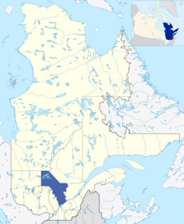
La Tuque is a territory equivalent to a regional county municipality (TE) and census division (CD) of Quebec. Its geographical code is 90.
Le Haut-Saint-Maurice Regional County Municipality was a former regional county municipality and census division in the Mauricie region of Quebec, Canada. It was formed on January 1, 1982, and dissolved on March 26, 2003, when it was amalgamated in its entirety into the new City of La Tuque. The La Tuque census division, a territory equivalent to a regional county municipality, is contiguous with the former Le Haut-Saint-Maurice RCM.
Batiscanie is the watershed of the Batiscan River, located in the center of the province of Quebec, Canada, covering 4690 km² on the North Shore of the St. Lawrence River. The area covered by Batiscanie is 53% in the administrative région of Mauricie and 47% in the administrative region of the Capitale-Nationale.
The Batiscan Lake is located in Upper Batiscanie and is the limit of unorganized territories of Lac-Blanc and Lac-Croche. This territory is related to the La Jacques-Cartier Regional County Municipality, in the administrative region of the Capitale-Nationale, in the province of Quebec, Canada.
The river Bostonais or Bostonians is a river of Canada, located in Quebec, in the administrative region of Mauricie, in La Tuque.
The Grand Lake Bostonnais is located in the La Tuque, in the administrative region of Mauricie, in Quebec, Canada. This lake is an important body of water is feeding the Bostonnais River which pours at La Tuque in Saint-Maurice River. The territory around Grand Lake Bostonnais is entirely in forest.
The Lake Kiskissink is located in the La Tuque, in Mauricie, in Quebec, in Canada. The area surrounding the lake is administered by the Zec Kiskissink

The lac Ventadour is the main headwater lake of the Bostonnais River. This lake is located in the La Tuque, in Mauricie, in Quebec, in Canada. The area around the lake is mostly administered by the Zec Kiskissink.
The Lake Lescarbot is located in the La Tuque, in Mauricie, in Quebec, in Canada. The territory is administered by Zec Kiskissink.

The ZEC de la Croche is a "zone d'exploitation controlée" (ZEC) in La Tuque, in administrative region of Mauricie, in Québec, in Canada. This public hunting and fishing area is located 18 km north of La Tuque and offers the public an area of 351.8 square kilometres (135.8 sq mi). The zec is managed by the "Sacerf La Croche Association".
The Zec de la Bessonne is a "zone d'exploitation contrôlée" (ZEC) near La Tuque in administrative region of Mauricie, in Quebec, in Canada. A territory of 524.5 square kilometres (202.5 sq mi) was assigned in 1978 to the Zec.
The Zec Kiskissink is a "zone d'exploitation contrôlée" (zec), located in the administrative region of the Mauricie, the Capitale-Nationale and Saguenay-Lac-Saint-Jean, in Quebec, in Canada. This wild territory, used for recreative activities is managed by the "Sacerf Macousine Association".
The ZEC Borgia is a "zone d'exploitation contrôlée" (ZEC) located in La Tuque, in administrative region of Mauricie, Quebec, Canada.
The Zec Ménokéosawin is a "zone d'exploitation contrôlée", located in the region of Mauricie, in Quebec, Canada. This public hunting and fishing area is managed by the "Association de chasse-pêche de la rivière Bostonnais Nord", a non-profit organization.
The lac Métabetchouane is a fresh body of water crossed by the Métabetchouane River, in the unorganized territory of Lac-Moncouche, in the Lac-Saint-Jean-Est Regional County Municipality, in the administrative region of Saguenay–Lac-Saint-Jean, in the province in Quebec, to Canada. This lake constitutes the demarcation between the Laurentides Wildlife Reserve and zec Kiskissink.

