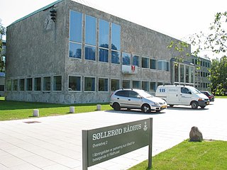
Until 1 January 2007 Søllerød was a municipality in Copenhagen County on the east coast of the island of Zealand (Sjælland) in eastern Denmark. The municipality covered an area of 39.77 km2, and had a total population of 31,920 (2006). Its mayor was Erik Fabrin, a member of the Venstre political party.

USS Briscoe (DD-977), named after Admiral Robert Pearce Briscoe USN, was a Spruance-class destroyer built by the Ingalls Shipbuilding Division of Litton Industries at Pascagoula, Mississippi. She was laid down 21 July 1975, launched 28 December 1976 and commissioned 3 June 1978. The ship operated from Norfolk, Virginia during her entire 25-year career. When decommissioned, she was part of Destroyer Squadron 22.

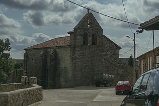
Torsnes is a former municipality in Østfold county, Norway. It is the site of Torsnes Church.

Sirník is a village and municipality in the Trebišov District in the Košice Region of south-eastern Slovakia.
Babianka is a village in the administrative district of Gmina Parczew, within Parczew County, Lublin Voivodeship, in eastern Poland. It lies approximately 14 kilometres (9 mi) south of Parczew and 35 km (22 mi) north-east of the regional capital Lublin.
Dehesa de Montejo is a municipality located in the province of Palencia, Castile and León, Spain. According to the 2004 census (INE), the municipality has a population of 195 inhabitants.
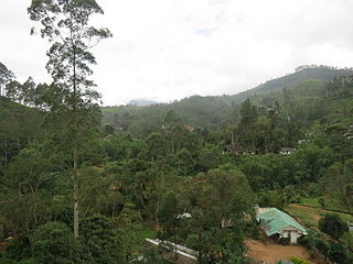
Dalhousie, Nallathanniya or Delhousie is a village in Nuwara Eliya District, Sri Lanka. The place is situated en route to Adam's Peak. The village borrowed its name from a nearby tea estate.
Ko. Madhepura is a village development committee in Saptari District in the Sagarmatha Zone of south-eastern Nepal. At the time of the 2011 Nepal census it had a population of 4,608.
Oro Verde is a village and municipality in Entre Ríos Province in north-eastern Argentina.
Burađa is a village in the municipality of Nova Varoš, western Serbia. According to the 2002 census, the village has a population of 258 people.
Maljkovo is a settlement in the Hrvace municipality in Croatia. It is connected by the D1 highway.
Kasunko is a chiefdom in Koinadugu District of Sierra Leone with a population of 20,357. Its principal town is Fadugu.
Aghbar is a small town and rural commune in Al Haouz Province of the Marrakesh-Tensift-El Haouz region of Morocco. At the time of the 2004 census, the commune had a total population of 4608 people living in 823 households.

German submarine U-517 was a Type IXC U-boat of the Nazi Germany's Kriegsmarine during World War II.
Pandia is a village in Purushottampur block, Ganjam district, Odisha, India.
Zahir Pir Railway Station is located in Pakistan.

Kaniasso Department is a department of Folon Region in Denguélé District, Ivory Coast. In 2021, its population was 84,572 and its seat is the settlement of Kaniasso. The sub-prefectures of the department are Goulia, Kaniasso and Mahandiana-Sokourani.

German submarine U-1109 was a Type VIIC/41 U-boat of Nazi Germany's Kriegsmarine during World War II.
