
The Kitt Peak National Observatory (KPNO) is a United States astronomical observatory located on Kitt Peak of the Quinlan Mountains in the Arizona-Sonoran Desert on the Tohono Oʼodham Nation, 88 kilometers (55 mi) west-southwest of Tucson, Arizona. With more than twenty optical and two radio telescopes, it is one of the largest gatherings of astronomical instruments in the Earth's northern hemisphere.

Tunisia is a country in Northern Africa, bordering the Mediterranean Sea, having a western border with Algeria (965 km) and south-eastern border with Libya (459 km) where the width of land tapers to the south-west into the Sahara. The country has north, east and complex east-to-north coasts including the curved Gulf of Gabès, which forms the western part of Africa's Gulf of Sidra. Most of this greater gulf forms the main coast of Libya including the city of Sirte which shares its root name. The country's geographic coordinates are 34°00′N9°00′E. Tunisia occupies an area of 163,610 square kilometres, of which 8,250 are water. The principal and reliable rivers rise in the north of the country with a few notable exceptions from north-east Algeria and flow through the northern plain where sufficient rainfall supports diverse plant cover and irrigated agriculture.

Turquoise is an opaque, blue-to-green mineral that is a hydrous phosphate of copper and aluminium, with the chemical formula CuAl6(PO4)4(OH)8·4H2O. It is rare and valuable in finer grades and has been prized as a gemstone for millennia due to its hue.
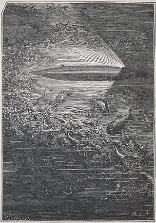
Nautilus is the fictional submarine belonging to Captain Nemo featured in Jules Verne's novels Twenty Thousand Leagues Under the Seas (1870) and The Mysterious Island (1875). Verne named the Nautilus after Robert Fulton's real-life submarine Nautilus (1800). For the design of the Nautilus, Verne was inspired by the French Navy submarine Plongeur, a model of which he had seen at the 1867 Exposition Universelle, three years before writing his novel.

Lake Turkana is a saline lake in the Kenyan Rift Valley, in northern Kenya, with its far northern end crossing into Ethiopia. It is the world's largest permanent desert lake and the world's largest alkaline lake. By volume it is the world's fourth-largest salt lake after the Caspian Sea, Issyk-Kul, and Lake Van, and among all lakes it ranks 24th.

Lake Winnebago is a shallow freshwater lake in the north central United States, located in east central Wisconsin. At 137,700 acres, it is the largest lake entirely within the state, covering an area of about 30 miles by 10 miles with 88 miles of shoreline, an average depth of 15.5 feet, and a maximum depth of 21 feet. It has many shallow reefs along the west shore and a drop-off type shoreline on the east. There are several islands along the west shore.
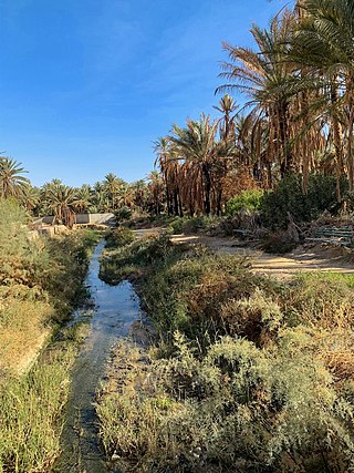
el-Djerid, also al-Jarīd, or more precisely the South Western Tunisia Region is a semi-desert natural region comprising three southern Tunisian Governorates, Gafsa, Kebili and Tozeur with adjacent parts of Algeria and Libya.
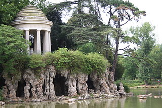
The Bois de Vincennes, located on the eastern edge of Paris, France, is the largest public park in the city. It was created between 1855 and 1866 by Emperor Napoleon III.

The Badain Jaran Desert is a desert in China which spans the provinces of Gansu, Ningxia and Inner Mongolia. It covers an area of 49,000 square kilometers. By size it is the third largest desert in China.

Gafsa is the capital of Gafsa Governorate of Tunisia. With a population of 111,170, Gafsa is the ninth-largest Tunisian city and it is 335 kilometers from the capital Tunis.

Dos Ojos is part of a flooded cave system located north of Tulum, on the Caribbean coast of the Yucatán Peninsula, in the state of Quintana Roo, Mexico. The exploration of Dos Ojos began in 1987 and still continues. The surveyed extent of the cave system is 82 kilometers (51 mi) and there are 28 known sinkhole entrances, which are locally called cenotes. In January 2018, a connection was found between Sistema Dos Ojos and Sistema Sac Actun. The smaller Dos Ojos became a part of Sac Actun, making the Sistema Sac Actun the longest known underwater cave system in the world.

Tozeur is the westernmost of the 24 governorates (provinces) of Tunisia and as such bordering Algeria. It covers an area of 4,719 km2 and has a population of 107,912 making it the least populated province. The capital is Tozeur.

Chott el Djerid also spelled Sciott Gerid and Shott el Jerid, is a chott, a large endorheic salt lake in southern Tunisia. The name can be translated from the Arabic into English as "Lagoon of the Land of Palms".
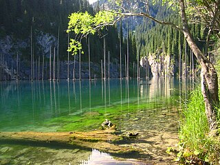
Lake Kaindy is a 400-meter-long (1,300 ft) lake located in Kazakhstan. The lake reaches depths of nearly 30 meters (98 ft). It is located 129 kilometers (80 mi) east-southeast of the city of Almaty and is 2,000 meters (6,600 ft) above sea level.

The Tunisian Air Force is one of the branches of the Tunisian Armed Forces.

Lac Pavin or Lake Pavin is a meromictic crater lake, located in the Dore mountains, in Auvergne, in the territory of the commune of Besse-et-Saint-Anastaise, Puy-de-Dôme department of France, between Besse-en-Chandesse and Super-Besse. Formed by phreatomagmatism 6,900 years ago, this crater lake is the youngest volcano in mainland France
The Société Nationale des Chemins de Fer Tunisiens, abbreviated SNCFT, is the national railway of Tunisia and under the direction of the Ministry of Transport. SNCFT was founded on December 27, 1956 It Replaced the Tunisian Railway Farms Company (CFT). Headquartered in Tunis the company employs about 6000 people. SNCFT provides both passenger and freight services at a national level.
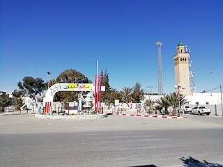
Métlaoui is a town and commune in the Gafsa Governorate, Tunisia. In 2014 it had a population of 38,634.

The Compagnie des phosphates de Gafsa or CPG is a Tunisian phosphate mining company based in Gafsa, formed in the late 19th century during the French colonial era, and once the largest employer in the country. It was merged in 1994 with the Groupe chimique tunisien (CGT) to form the CPG-CGT group. Before the revolution of 2011 the company was the fifth largest phosphate producer in the world, but since then strikes and social unrest have caused production to drop by half.

Gafsa Oases are date palm oases at Gafsa in southwestern Tunisia, near the northern edge of the Sahara Desert. The Gafsa Oases were known to the ancient Romans and cover approximately 700 hectares. The oases were designated a Globally Important Agricultural Heritage System in 2011. The individual oases are called Sakdoud, Ksar, Lela, Gafsa and El Guettar.


