
The Yvette is a small river in southern Île-de-France (France), left tributary of the Orge, which is a tributary of the Seine. It is 39.3 km (24.4 mi) long. Its source is in Les Essarts-le-Roi, north of Rambouillet, in the Yvelines department. Various communes of the Essonne département are named after it: Bures-sur-Yvette, Gif-sur-Yvette and Villebon-sur-Yvette.
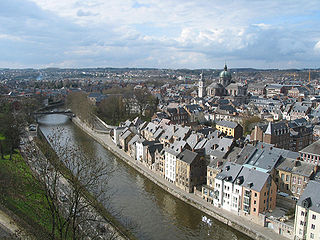
The Sambre is a river in northern France and in Wallonia, Belgium. It is a left-bank tributary of the Meuse, which it joins in the Wallonian capital Namur.

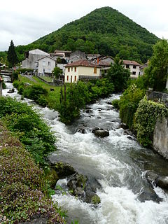
Asson is a commune in the Pyrénées-Atlantiques department in the Nouvelle-Aquitaine region of south-western France.
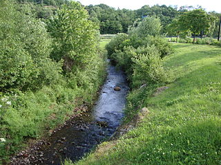
The Valentine is a stream in the Haute-Vienne department, France. It is a tributary of the Boucheuse, and part of the Dordogne basin. It is 12.3 km (7.6 mi) long.

The Thérain is a river in France, tributary of the Oise. It is 94.4 km (58.7 mi) long. It rises between Saint-Michel-d'Halescourt and Grumesnil in Seine-Maritime at 175 meters elevation. It flows generally southeast, through Songeons, Milly-sur-Thérain, Beauvais, Hermes and Mouy, and joins the Oise at Creil.

The Aigues, Aigue, Aygues or Eygues is a French river, a tributary of the Rhône. It runs through the departments of Drôme, Hautes-Alpes and Vaucluse. Its source is in the Baronnies mountains. It flows through Verclause, Sahune, Nyons, and it flows into the Rhône at Caderousse. It is 113.7 km (70.6 mi) long. Its drainage basin is 1,012 km2 (391 sq mi).
The Orbe is a river of the Rhine basin. It starts in France and flows to Switzerland where it forms the river Thielle at its confluence with the river Talent. Not to be mistaken with the Orbe, which is a tributary of the Arrats.

The Jamagne is a short river of 6.9 kilometres (4.3 mi), an emissary of the lac de Gérardmer which is its source. It flows into the Vologne as a left tributary at Kichompré.
The Ondaine or Ondenon is a river in the Loire department of France. It is a right tributary of the Loire.
The Ourse, or Ourse de Ferrère, is a French river in the Pyrenees, a tributary of the Garonne. It is 25.4 km (15.8 mi) long. It forms the Barousse valley.

The Volane is a 22.5-kilometre-long (14.0 mi) French river, a tributary of the Ardèche and a sub-affluent of the Rhône.
The Zorn is a river that flows through the Lorraine and the Alsace as the largest and last of the tributaries of the river Moder, before the latter empties into the Rhine. It rises on the territory of Walscheid as the Yellow Zorn and becomes the Zorn after its confluence with the right-hand tributary, the White Zorn. It has a length of just under 97 kilometres and drains an area of 757 km². The French spelling Zorn first surfaced in the 18th century. Hitherto the river was called the Sorn, which stems from the pre-Celtic era and probably meant "the flowing one". The upper reaches of the river as far as Saverne are viewed as having great, scenic beauty and are also home to many fine examples of architecture.
The Soultzbach is a river in Alsace, France. It is 10 kilometres (6.2 mi) long, and is a right tributary of the Sauer.

The Acheneau is a French river in the Loire-Atlantique Department, in the Pays de la Loire region, a tributary on the left bank of the Loire which is fed by the Lac de Grand-Lieu.

The Arguenon is a French coastal river in the Côtes-d'Armor department of the Brittany region. It flows into the English Channel.

The Haute Perche Canal, despite its title, is a natural river, the Rivière de Haute-Perche, that has been slightly canalised to improve navigation between its mouth in the Bay of Bourgneuf at the port town of Pornic and the upstream settlements of Le Clion-sur-Mer, Chauvé and Arthon-en-Retz. It is located in the Pays de Retz in the Loire-Atlantique department and the Pays de la Loire region. It has also been known as the Canal de Pornic since the 16th century and was sometimes called the Étier de Haute Perche. Historically, it was called the Rouet, after the wheels of the water mills in the port.

The Abatesco is a French coastal river which flows through the Haute-Corse department and empties into the Tyrrhenian Sea.

The Restonica is a small river in the department of Haute-Corse, Corsica, France. It is a tributary of the river Tavignano. The river has a steep and rocky course with many pools and waterfalls. The valley contains two lakes, and is a popular tourist destination.

The Corsiglièse is a stream in the department of Haute-Corse, Corsica, France. It is a tributary of the river Tavignano.


