
The Gulf of St. Lawrence is the outlet of the North American Great Lakes via the St. Lawrence River into the Atlantic Ocean. The gulf is a semi-enclosed sea, covering an area of about 226,000 square kilometres (87,000 sq mi) and containing about 34,500 cubic kilometres (8,300 cu mi) of water, which results in an average depth of 152 metres (499 ft).

The Sulu Sea is a body of water in the southwestern area of the Philippines, separated from the South China Sea in the northwest by Palawan and from the Celebes Sea in the southeast by the Sulu Archipelago. Borneo is found to the southwest and Visayas to the northeast.
A marine park is a designated park consisting of an area of sea set aside to achieve ecological sustainability, promote marine awareness and understanding, enable marine recreational activities, and provide benefits for Indigenous peoples and coastal communities. Most marine parks are managed by national governments, and organized like 'watery' national parks, whereas marine protected areas and marine nature reserves are often managed by a subnational entity or non-governmental organization, such as conservation authority.

The Timor Sea is a relatively shallow sea bounded to the north by the island of Timor, to the east by the Arafura Sea, and to the south by Australia.

The Arafura Sea lies west of the Pacific Ocean, overlying the continental shelf between Australia and Western New Guinea, which is the Indonesian part of the Island of New Guinea.

The South West Cape is a cape located at the south-west corner of Tasmania, Australia. The cape is situated in the south-western corner of the Southwest National Park, part of the Tasmanian Wilderness World Heritage Area, approximately 140 kilometres (87 mi) southwest of Hobart in Tasmania, and about 65 kilometres (40 mi) west and a little north of the South East Cape.
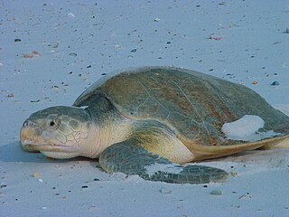
Kemp's ridley sea turtle, also called the Atlantic ridley sea turtle, is the rarest species of sea turtle and is the world's most endangered species of sea turtle. It is one of two living species in the genus Lepidochelys.

The Australian flatback sea turtle is a species of sea turtle in the family Cheloniidae. The species is endemic to the sandy beaches and shallow coastal waters of the Australian continental shelf. This turtle gets its common name from the fact that its shell has a flattened or lower dome than the other sea turtles. It can be olive green to grey with a cream underside. It averages from 76 to 96 cm in carapace length and can weigh from 70 to 90 kg. The hatchlings, when emerging from nests, are larger than other sea turtle hatchlings when they hatch.

Wyndham is the northernmost town in the Kimberley region of Western Australia, located on the Great Northern Highway, 2,210 kilometres (1,373 mi) northeast of Perth. It was established in 1886 to service a new goldfield at Halls Creek, and it is now a port and service centre for the east Kimberley with a population of 780. Aboriginal and Torres Strait Islander people make up 54% of the population. Wyndham comprises two areas - the original town site at Wyndham Port situated on Cambridge Gulf, and 5 kilometres (3.1 mi) by road to the south, the Three Mile area with the residential and shopping area for the port, also founded in 1886. Wyndham is part of the Shire of Wyndham-East Kimberley.
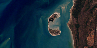
Crab Island, called Moent Island in the native language, is a now uninhabited island west of Muttee Heads and the coastal community of Seisia which is adjacent to Bamaga at the tip of Cape York Peninsula within the Endeavour Strait in the Gulf of Carpentaria in Queensland, Australia. It is around 280 hectares. The distance to the closest mainland is 1.4 kilometres (0.87 mi). The original inhabitants were the Apukwi branch of the Ankamuti.

King Sound is a large gulf in northern Western Australia. It expands from the mouth of the Fitzroy River, one of Australia's largest watercourses, and opens to the Indian Ocean. It is about 120 kilometres (75 mi) long, and averages about 50 kilometres (31 mi) in width. The port town of Derby lies near the mouth of the Fitzroy River on the eastern shore of King Sound. King Sound has the highest tides in Australia, and amongst the highest in the world, reaching a maximum tidal range of 11.8 metres (39 ft) at Derby. The tidal range and water dynamic were researched in 1997–1998.
Western Australia has the longest coastline of any state or territory in Australia, at 10,194 km or 12,889 km. It is a significant portion of the coastline of Australia, which is 35,877 km.
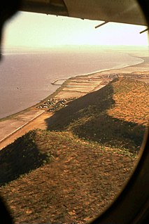
Cambridge Gulf is a gulf on the north coast of the Kimberley region of Western Australia. Many rivers flow into the gulf, including the Ord River, Pentecost River, Durack River, King River and the Forrest River, making the environment an estuarine one.
The Forrest River is a river in the Kimberley region of Western Australia.

The King River is a river in the Kimberley region of Western Australia.

The borders of the oceans are the limits of Earth's oceanic waters. The definition and number of oceans can vary depending on the adopted criteria. The principal divisions of the five oceans are the Pacific Ocean, Atlantic Ocean, Indian Ocean, Southern (Antarctic) Ocean, and Arctic Ocean. Smaller regions of the oceans are called seas, gulfs, bays, straits, and other terms. Geologically, an ocean is an area of oceanic crust covered by water.

During the Australian gold rushes, starting in 1851, significant numbers of workers moved from elsewhere in Australia and overseas to where gold had been discovered. Gold had been found several times before, but the colonial government of New South Wales had suppressed the news out of the fear that it would reduce the workforce and so destabilise the economy.
Cape Domett is at the eastern side of the mouth of the Cambridge Gulf in the Kimberley region of Western Australia.
Cape Dussejour is located at the western side of the entrance to the Cambridge Gulf in the Kimberley region of Western Australia.
Thevenard Island is located approximately 22 kilometres (14 mi) off the coast of Onslow in the Pilbara region of Western Australia.