Related Research Articles
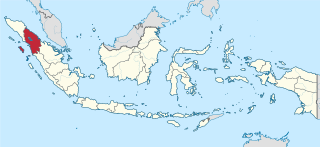
North Sumatra is a province of Indonesia. It consists of a large northwestern belt of the island of Sumatra and its capital is Medan. North Sumatra is the fourth most-populous province after West Java, East Java and Central Java — it covers an area of 72,981 km2, and at the Census of 2020 it had a population of 14,799,361.

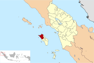
The Mentawai Islands Regency are a chain of about seventy islands and islets approximately 150 kilometres off the western coast of Sumatra in Indonesia. They cover 6,011.35 sq2 and had a population of 76,173 at the 2010 Census and 85,156 at the 2015 Census; the latest official estimate is 92,021. Siberut at 3,838.25 square kilometres is the largest of the islands. The other major islands are Sipura, North Pagai and South Pagai. The islands lie off the Sumatran coast, across the Mentawai Strait. The indigenous inhabitants of the islands are known as the Mentawai people. The Mentawai Islands have become a noted destination for surfing, with over 40 boats offering surf charters to international guests.
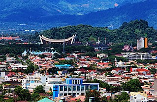
Padang is the capital and largest city of the Indonesian province of West Sumatra. With an estimated population of 939,112 as of 2018, it is the 16th most populous city in Indonesia and the most populous city on the west coast of Sumatra. The Padang metropolitan area is the third most populous metropolitan area in Sumatra with a population of over 1.4 million. Padang is widely known for its Minangkabau culture, cuisine, and sunset beaches.

Nias is an island located off the western coast of Sumatra, Indonesia. Nias is also the name of the archipelago of which the island is the centre, but also includes the Batu Islands to the south-east and the small Hinako Islands to the west. Nias Island covers an area of 5,625.0 km2 (2,171.8 sq mi). It is mostly a lowland area rising to around 800 m (2,600 ft) above sea level. There were 756,338 inhabitants on the island at the 2010 Census; at the 2015 Census this had risen to 798,506 and the 2020 Census resulted in a total of 880,550.

Simeulue Regency is a regency in the Aceh special region of Indonesia. It occupies the whole island of Simeulue, 150 km off the west coast of Sumatra, with an area of 1,838.09 square kilometres. It had a population of 80,674 at the 2010 Census; the latest official estimate is 93,720.

Indonesia was the first country to be seriously affected by the earthquake and tsunami created by the 2004 Indian Ocean earthquake on 26 December 2004, swamping the northern and western coastal areas of Sumatra, and the smaller outlying islands off Sumatra. Nearly all the casualties and damage took place within the province of Aceh. The time of arrival of the tsunami was between 15 and 30 minutes after the deadly earthquake.

Great Aceh Regency is a regency of the Indonesian province of Aceh. The regency covers an area of 2,903 square kilometres and according to the 2010 census had a population of 351,418; the latest official estimate is 425,216. The Regency is located at the northwest tip of Sumatra island and surrounds the provincial capital of Banda Aceh. It includes a number of islands off the northern tip of Sumatra, which comprise Pulo Aceh district within the regency. The seat of the Regency government is the town of Jantho.

Aceh Jaya Regency is a regency (kabupaten) of Aceh Special Region, Indonesia. It is located on the island of Sumatra. The regency covers an area of 3,812.99 square kilometres and according to the 2010 census had a population of 76,782 people; the latest official estimate is 92,893. The seat of the Regency is Calang. The main crops grown in the Regency are rice, rambutan, durian, orange, water melon, rubber, palm and coconut oil.
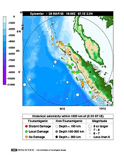
The 2005 Nias–Simeulue earthquake occurred on 28 March off the west coast of northern Sumatra, Indonesia. At least 915 people were killed, mostly on the island of Nias. The event caused panic in the region, which had already been devastated by the massive tsunami triggered by the 2004 Indian Ocean earthquake, but this earthquake generated a relatively small tsunami that caused limited damage. It was the third most powerful earthquake since 1965 in Indonesia.

Gunungsitoli is the capital city of Nias Regency, North Sumatra province, Indonesia, but is also an independent municipality within the province, separate from any regency. It is located at 1°17′N97°37′E. It is a coastal city located on Nias island, which is located in the Indian Ocean, on the west side of Sumatra. The city covers an area of 469.36 km2 and had a population of 126,202 at the 2010 Census and 136,017 at the 2020 Census. On 28 March 2005, the Nias–Simeulue earthquake destroyed parts of the city and caused casualties. The city is served by Binaka Airport with flights to Medan and Jakarta.
Lagundri Bay, or Sorake Bay, is a horseshoe-shaped bay at the southern end of the island of Nias off the coast of Sumatra in Indonesia. It is a popular tourist destination and a noted surf break.

The Banyak Islands are a group of inhabited islands located between Simeulue and Nias off the western coast of Sumatra in Indonesia's Aceh Province. Surveys of the area approximate around 71 islands and additional mangrove stands in shallow off-shore areas, although locals count 99 islands. The largest island in the group is Tuangku, with the principal town of Haloban. Two other major islands located either side of Tuangku are Bangkaru and Ujung Batu. Tuangku is separated from Bangkaru by a fault line.
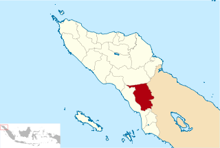
Southeast Aceh Regency is a regency in the Aceh special region of Indonesia. It is located on the island of Sumatra. The regency covers an area of 4,231.41 square kilometres and according to the 2010 census had a population of 179,010 people; the latest official estimate is 213,222. The seat of the regency government is at Kutacane. In 1974, the Southeast Aceh Regency was separated from the Central Aceh Regency; however in 2002 the northern part of this regency was itself split away to form the new Gayo Lues Regency. The main commodities produced in the regency are palm oil, cacao, coconut, coffee, nutmeg, walnut, and pachouli oil The main rivers are the Alas River and the Butan River. It contains the Leuser Ecosystem.

Nias Regency is a regency in North Sumatra province, Indonesia; it lies on the east side of Nias Island. The regency formerly covered the entire island, and had an area of 3,495.39 square kilometres following the creation of the new regency of Nias Selatan but prior to the creation of the new regencies of Nias Utara and Nias Barat and the independent municipality of Gunungsitoli from parts of Nias Regency. Since the separation of the new regencies and municipality, the reduced Regency now covers 853.42 km2, and had a population of 131,377 at the 2010 Census and 146,672 at the 2020 Census. Its seat is the town of Gido.

West Nias Regency is a regency in North Sumatra province of Indonesia. The regency seat is Lahomi. It covers the western portion of Nias Island. The Regency covers an area of 520.34 km2, and had a population of 81,807 at the 2010 Census and 89,994 at the 2020 Census. This regency was founded in 2008 by UU (Law) No.46 Tahun (Year) 2008; formerly, the area was part of Nias Regency.

Nias Selatan Regency is a regency in North Sumatra province, Indonesia. The regency covers a land area of 2,487.98 square kilometres and according to the 2010 census had a population of 289,708; the 2020 Census showed a population of 360,531. Its administrative centre is the port of Teluk Dalam. Apart from the southern portion of Nias Island, the regency also includes the smaller Batu Islands to the south, lying between Nias and Siberut.
Nias Utara Regency is a regency in North Sumatra province of Indonesia. It comprises the northern portion of Nias Island and has an area of 1,242.14 km2. It had a population of 127,244 at the 2010 Census and 147,274 at the 2020 Census.
The Simeulue language is spoken by the Devayan people of Simeulue off the western coast of Sumatra, Indonesia.

Sikakap is a sub-district on the Indonesian island of North Pagai, in the Mentawai Islands off Sumatra. The sub-district contains both Sikakap and Matobe, while Sikakap village incorporates the hamlets of Central Sikakap, East Sikakap and Sibaibai. Overall, the total population was 3,194 as of 2016. Also part of the sub-district is the Sikakap Strait between North and South Pagai, a designated Regional Marine Conservation Area. The Strait, an area of 3,960 hectares, has a coastal length of 19.79 kilometres (12.30 mi) and is a major contributor to West Sumatra's fishing industry.
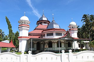
Masjid Raya Syekh Burhanuddin is one of the oldest mosques as well as a cultural heritage in West Sumatra, Indonesia. The mosque is located in Nagari Ulakan, Ulakan Tapakis sub-district, Padang Pariaman district of West Sumatra.
References
- ↑ Indonesia Food, Beverage and Tobacco Export-import and Business Opportunities Handbook. Int'l Business Publications. 20 March 2009. p. 73. ISBN 978-1-4387-2342-6.
- ↑ Hummel, U.; Telaumbanua, Tuhoni (20 September 2007). Cross and adu: a socio-historical study on the encounter between Christianity and the indigenous culture on Nias and the Batu Islands, Indonesia (1865-1965). Boekencentrum. p. 13.
- ↑ Schefold, R. (1 January 2008). Indonesian Houses: Volume 2: Survey of Vernacular Architecture in Western Indonesia. BRILL. p. 175. ISBN 978-90-04-25398-8.
- ↑ "Indonesia, Nias: It's all about behaviour change". International Federation of Red Cross. Retrieved 4 August 2015.
- ↑ Peran Masyarakat Dalam Pembangunan Wilayah Melalui Pengembangan Kewirausahaan. JICA. 2006.
- ↑ "2013唐崇榮牧師印尼國家巡迴佈道會" (in Chinese). Stephen Tong Evangelistic Ministries International. Retrieved 4 August 2015.
- 1 2 "Lahewa". Northniastourism.com. Retrieved 4 August 2015.
- ↑ Buletin Persatuan Geologi Malaysia. Penerbit Universiti Malaya. 1995. pp. 112–15.