Interstate 49 (I-49) is a north–south Interstate Highway that exists in multiple segments: the original portion entirely within the state of Louisiana with an additional signed portion extending from I-220 in Shreveport to the Arkansas state line, four newer sections in Arkansas, and a new section that opened in Missouri. Its southern terminus is in Lafayette, Louisiana, at I-10 while its northern terminus is in Kansas City, Missouri at I-435 and I-470. Portions of the remaining roadway in Louisiana, Arkansas, Missouri, and Texas, which will link Kansas City with New Orleans, are in various stages of planning or construction.

Bella Vista is a city in Benton County, Arkansas, United States. First established in 1917 as a summer resort destination, Bella Vista has evolved and redesigned itself over the succeeding years. Bella Vista became a retirement community in 1965, and, after much contention and a 2006 vote of its property owners, became an incorporated city. Following its official incorporation on January 1, 2007, the new city government took over the police department, fire department, streets, trash removal and other city functions, while the Property Owners Association (POA) retained control of the many amenities available to homeowners and their guests. Amenities include numerous parks, clubhouses with workout areas, swimming pools, six 18-hole golf courses, one nine-hole golf course, seven lakes with fishing and boat docks, a marina, swimming beach, putt putt golf courses and tennis courts, dog park, softball field, and extensive hiking and biking trails.

Bentonville is the ninth-largest city in Arkansas, United States and the county seat of Benton County. The city is centrally located in the county with Rogers adjacent to the east. The city is the birthplace and world headquarters of Walmart, the world's largest retailer. It is one of the four main cities in the three-county Northwest Arkansas Metropolitan Statistical Area, which is ranked 109th in terms of population in the United States with 463,204 residents in 2010, according to the United States Census Bureau. The city itself had a population of 35,301 at the 2010 Census, with an estimated population of 54,909 in 2019.
Bella Vista is the name of several places in the world:
Lake Bella Vista may refer to:

Lake Windsor is a man-made lake in the Bella Vista area of Benton County in northwest Arkansas, United States. The lake is on Tanyard Creek just upstream from its confluence with Little Sugar Creek.

Lake Brittany is a small lake in the Bella Vista area in Benton County in Northwest Arkansas. It is located on a small north flowing tributary to Pinion Hollow and lies upstream of Lake Ann about 2.5 miles (4.0 km) east of Bella Vista. The dam is off Trafalgar Road.
Tanyard Creek is a stream in Benton County in northwest Arkansas. It is a tributary of Little Sugar Creek in the Bella Vista resort region of northwest Benton County.
Interstate 49 (I-49) is an Interstate Highway in the state of Arkansas. There are two main sections of the highway, split by construction. The northern section begins at I-40 and at U.S. Highway 71 (US 71) in Alma, Arkansas and runs north to Bella Vista, Arkansas, where the freeway terminates, awaiting completion of the Bella Vista Bypass. The second, southern section starts at the Louisiana state line, then runs to Texarkana, at the Texas state line.
U.S. Route 71 (US 71) is a major north–south U.S. Highway that runs from Louisiana to Canada. US 71 enters Missouri from Arkansas in the town of Jane. US 71 serves the cities of Joplin, Kansas City and St. Joseph. At noon on December 12, 2012, the section of US 71 between Pineville, Missouri and Bannister Road in south Kansas City was also designated as a northern extension of Interstate 49 (I-49).

Highway 340 is an east–west state highway in Benton County, Arkansas. The route of 9.21 miles (14.82 km) runs entirely across Bella Vista, from Arkansas Highway 279 in the west to Arkansas Highway 94 in the east.
Interstate 49 (I-49) is an Interstate Highway in the U.S. state of Missouri that was designated on December 12, 2012. It overlaps U.S. Route 71 (US 71) in the western part of the state, beginning at Pineville, just a few miles north of the Arkansas state line, and ending at I-435 and I-470 on the southeast side of Kansas City.

Township 7 is one of thirteen current townships in Benton County, Arkansas, United States. As of the 2010 census, its population was 20,317.

Mildred B. Cooper Memorial Chapel is a chapel located along Lake Norwood in Bella Vista, Arkansas, designed by E. Fay Jones and Maurice Jennings and constructed in 1988. The chapel was commissioned by John A. Cooper, Sr. to honor Mildred Borum Cooper, his late wife. The chapel was designed with a mind toward celebrating both God and his creations.

U.S. Highway 71 is a U.S. highway that runs from Krotz Springs, LA to the Fort Frances–International Falls International Bridge at the Canadian border. In Arkansas, the highway runs from the Louisiana state line near Doddridge to the Missouri state line near Bella Vista. In Texarkana, the highway runs along State Line Avenue with US 59 and partially runs in Texas. Other areas served by the highway include Fort Smith and Northwest Arkansas.

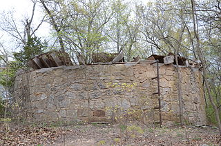
The Bella Vista Water Tank is a historic water tower at the junction of Cedar Crest and Cunningham Drives in Bella Vista, Arkansas. This native stone tank was built in 1927 by the Linebarger Brothers, under the supervision of Wallard Braithwaite, to store water for summer cottages on the west side of Lake Bella Vista and later the Sunset Hotel. It is significant as the only known water tank of its type in Benton County, Arkansas, and for its association with the early development of Bella Vista.

Wonderland Cave is the largest cave in northwestern Arkansas. It is located on Dartmoor Road in Bella Vista, northeast of Bella Vista Lake and east of United States Route 71. The cave was first developed in the 1920s, and transformed into a nightclub in the 1930s, finishing a cavernous space within it with a concrete floor, stage for musicians, and decorations reminiscent of Alice in Wonderland. Portions of the facility have also been used historically for the aging of locally produced wine, and at least one session of the Arkansas General Assembly has been held in the cave. A local organization is developing plans to reopen the site as a tourist attraction.

The Northwest Arkansas Razorback Regional Greenway is a 37.6 miles (60.5 km) primarily off-road shared-use trail in Northwest Arkansas. Dedicated on May 2, 2015, the Greenway connects Walker Park in Fayetteville, Arkansas to north of Lake Bella Vista in Bella Vista, Arkansas, while also serving schools, businesses and other cultural amenities along the route.

Norwest is a suburb of the Hills District within Greater Western Sydney, in the state of New South Wales, Australia, located 35 kilometres north-west of the Sydney central business district. The Norwest Business Park is located within Norwest. The council chambers for The Hills Shire Council are also located within this suburb.


