
Great Sandy National Park is a coastal national park in the Fraser Coast Region, Queensland, Australia.

K'gari, also known by its former name Fraser Island, is a World Heritage-listed sand island along the south-eastern coast in the Wide Bay–Burnett region of Queensland, Australia. The island is approximately 250 km (160 mi) north of the state capital, Brisbane, and is within the Fraser Coast Region local government area. The world heritage listing includes the island, its surrounding waters and parts of the nearby mainland which make up the Great Sandy National Park. In the 2021 census, the island had a population of 152 people. Up to 500,000 people visit the island each year.

Hervey Bay is a city on the coast of the Fraser Coast Region of Queensland, Australia. The city is situated approximately 290 kilometres (180 mi) or 3½ hours' highway drive north of the state capital, Brisbane. It is located on the bay of the same name open to the Coral Sea between the Queensland mainland and nearby K'gari. The local economy relies on tourism which is based primarily around whale watching in Platypus Bay to the north, ferry access to K'gari, accessible recreational fishing and boating and the natural north facing, calm beaches with wide undeveloped foreshore zones. In October 2019, Hervey Bay was named the First Whale Heritage Site in the world by the World Cetacean Alliance, for its commitment to and practices of sustainable whale and dolphin watching.

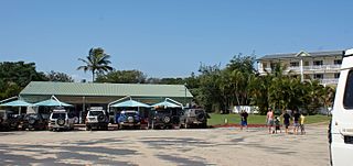
Inskip Point is a peninsula in the north of the locality of Inskip to the north of the town of Rainbow Beach in south-east Queensland, Australia. It is the vehicular gateway to Fraser Island, a popular recreational area.

Indian Head is a coastal headland on the eastern (ocean) side of Fraser Island off the coast of Queensland, Australia.

The Great Sandy Strait is a strait in the Australian state of Queensland of 70 kilometres (43 mi) length which separates mainland Queensland from K'gari. It is also a locality in the Fraser Coast Region local government area. To the north of the strait is Hervey Bay. In the 2021 census, Great Sandy Strait had "no people or a very low population".

The Fraser Coast Region is a local government area in the Wide Bay–Burnett region of Queensland, Australia, about 250 kilometres (160 mi) north of Brisbane, the state capital. It is centred on the twin cities of Hervey Bay and Maryborough and also contains K'gari. It was created in 2008 from a merger of the Cities of Maryborough and Hervey Bay and the Shires of Woocoo and most of Tiaro. The resident population at the 2021 census was 111,032 and the estimated population in 2023 was 117,940.

The K'gari Great Walk is a long-distance walking track on K'gari, Queensland, Australia. Hikers should be fully self-sufficient and to carry sufficient water. The walk is rated easy to moderate on a difficulty scale being mostly at sea level and is traversed in one direction.
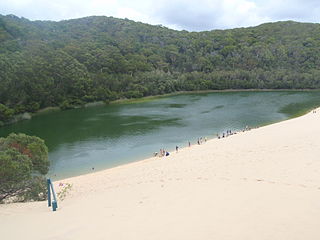
Lake Wabby is a small freshwater, green colored lake. It is located in the Great Sandy National Park on the eastern side of K'gari off the coast of Queensland, Australia. The lake is directly adjacent to the Hammerstone Sandblow, which is slowly moving into the lake. Eventually it will disappear under the sand.

The geography of Queensland in the north-east of Australia, is varied. It includes tropical islands, sandy beaches, flat river plains that flood after monsoon rains, tracts of rough, elevated terrain, dry deserts, rich agricultural belts and densely populated urban areas.

Sandy Cape is the most northern point on Fraser Island off the coast of Queensland, Australia. The place was named Sandy Cape for its appearance by James Cook during his 1770 voyage up the eastern coast of Australia aboard the Endeavour.

Sandy Cape Light is a heritage-listed active lighthouse located on Sandy Cape, the most northern point on K'gari, Queensland, Australia. It stands about 6 kilometres (3.7 mi) southwest of the northeastern tip of the island. It is the tallest lighthouse in Queensland. Built in 1870, it is the second major lighthouse to be built in Queensland after its formation in 1859. It is one of the first lighthouses in Australia to be constructed using bolted prefabricated segments of cast iron, and one of only two such lighthouses in Queensland, the other being its sibling, Bustard Head Light.

Lake McKenzie (Boorangoora) is a perched lake on K'gari or Fraser Island in Queensland, Australia. The lake is located in the Great Sandy National Park.

Wide Bay–Burnett is a region of the Australian state of Queensland, located between 170–400 km (110–250 mi) north of the state capital, Brisbane. The area's population growth has exceeded the state average over the past 20 years, and it is forecast to grow to more than 430,000 by 2031. It is the subject of the Draft Wide Bay–Burnett Regional Plan, which aims to facilitate this growth while protecting over 90% of the region from urban development.
Clifford Harry Thompson was an Australian geomorphologist and principal research scientist with the Commonwealth Scientific and Industrial Research Organisation (CSIRO). Thompson's extensive research into coastal soils was influential in establishing K'gari as a World Heritage Site and in the development and management of the Cooloola National Park, Queensland. In 2004, he was awarded an Order of Australia in recognition of his contribution to soil science as a researcher and educator, and as an advisor in land management practices and conservation issues.
Great Sandy Biosphere Reserve is a biosphere reserve in the Australian state of Queensland located on land and coastal waters associated both with the local government areas of the Fraser Coast Region and the Gympie Region and Fraser Island, and with the bay known as Hervey Bay.
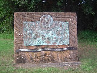
The Butchulla, also written Butchella, Badjala, Badjula, Badjela, Bajellah, Badtjala and Budjilla, are an Aboriginal Australian people of K'gari, Queensland, and a small area of the nearby mainland of southern Queensland.

Happy Valley is a coastal town in the locality of K'gari in the Fraser Coast Region, Queensland, Australia.
Eurong is an island town and a locality on K'gari in the Fraser Coast Region, Queensland, Australia. In the 2021 census, the locality of Eurong had a population of 11 people.
Tinnanbar is a coastal town and a locality in the Fraser Coast Region, Queensland, Australia. In the 2021 census, the locality of Tinnanbar had a population of 64 people.


