
Burkina Faso is a landlocked country in West Africa that covers an area of around 274,200 square kilometres (105,900 sq mi) and is bordered by Mali, Niger, Benin, Togo, Ghana, and Ivory Coast. The July 2019 population estimate by the United Nations was 20,321,378. Previously called Republic of Upper Volta (1958–1984), it was renamed "Burkina Faso" on 4 August 1984 by President Thomas Sankara. Its citizens are known as Burkinabé, and its capital is Ouagadougou. Due to French colonialism, the country's official language of government and business is French, but this language is spoken by approximately only 10-15% of the population. There are 59 native languages spoken in Burkina, with the most common language, Moore, spoken by roughly 50% of Burkinabé.

Burkina Faso is a landlocked Sahel country that shares borders with six nations. It lies between the Sahara desert and the Gulf of Guinea, south of the loop of the Niger River, mostly between latitudes 9° and 15°N, and longitudes 6°W and 3°E. The land is green in the south, with forests and fruit trees, and desert in the north. Most of central Burkina Faso lies on a savanna plateau, 198–305 metres (650–1,001 ft) above sea level, with fields, brush, and scattered trees. Burkina Faso's game preserves—the most important of which are Arly, Nazinga, and W National Park—contain lions, elephants, hippopotamus, monkeys, common warthogs, and antelopes. Previously the endangered painted hunting dog, Lycaon pictus occurred in Burkina Faso, but, although the last sightings were made in Arli National Park, the species is considered extirpated from Burkina Faso.

Ouagadougou is the capital of Burkina Faso and the administrative, communications, cultural, and economic centre of the nation. It is also the country's largest city, with a population of 2,200,000 in 2015. The city's name is often shortened to Ouaga. The inhabitants are called ouagalais. The spelling of the name Ouagadougou is derived from the French orthography common in former French African colonies.

A transboundary protected area (TBPA) is an ecological protected area that spans boundaries of more than one country or sub-national entity. Such areas are also known as transfrontier conservation areas (TFCAs) or peace parks.

Koudougou is a city in Burkina Faso's Boulkiemdé Province. It is located 75 kilometres (47 mi) west of Ouagadougou, the capital of Burkina Faso. With 131,825 inhabitants, as of 2006, it is the third largest city by population in Burkina Faso after Ouagadougou and Bobo Dioulasso and is mainly inhabited by the Gurunsi and Mossi ethnic groups. Koudougou is situated on the only railway line in Burkina Faso and has some small industries, a market, a university and provincial government offices.
The W National Park or W Regional Park is a major national park in West Africa around a meander in the River Niger shaped like the letter W. The park includes areas of the three countries Niger, Benin and Burkina Faso, and is governed by the three governments. Until 2008, the implementation of a regional management was supported by the EU-funded project ECOPAS. The three national parks operate under the name W Transborder Park.. The section of W National Park lying in Benin, measuring over 8,000 km2 (3,100 sq mi), came under the full management of African Parks in June 2020. In Benin, W National Park is contiguous with Pendjari National Park which is also under the management of African Parks.

The Oti River or Pendjari River is an international river in West-Central Africa. It rises in Benin, forms the border between Benin and Burkino Faso, flows through Togo, and joins the Volta River in Ghana.

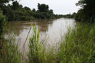
Arli National Park, often called Arly, is a national park located in Tapoa Province, southeastern Burkina Faso. It adjoins Benin's Pendjari National Park in the south and the Singou Reserve in the west.

Lake Bam is located near the town of Kongoussi, in Burkina Faso. The lake is slowly drying up, putting at risk the nearby village's agriculture, fish stocks, and cattle watering. The lake has been designated as a Ramsar site since 2009.

The Mare aux Hippopotames is a lake and national park in Burkina Faso, created in 1937 and designated in 1977 as the only UNESCO Biosphere Reserve in the nation. The park was created around a freshwater lake and includes surrounding pools and marches in the flood plain of the Black Volta River, and surrounding forests. The park is home to about 100 hippos; about 1000 eco-tourists visit each year. It is located about 60 kilometers (37 mi) north of Bobo-Dioulasso, and is itself about 163 square kilometres (63 sq mi) in size.

Burkina Faso is largely wild bush country with a mixture of grass and small trees in varying proportions. The savanna region is mainly grassland in the rainy season and semi desert during the harmattan period. Fauna, one of the most diverse in West Africa, includes the elephant, hippopotamus, buffalo, monkey, lions, crocodile, giraffe, various types of antelope, and a vast variety of bird and insect life. The country has 147 mammal species, 330 aquatic species including 121 species of fish and 2067 different plant species. Of the plant species, the dominant endemic species are shea tree (Butyrospermum parkii) and the baobab, the former plant species has immense economic value to the country.
The following outline is provided as an overview of and topical guide to Burkina Faso:

Téra is a department of the Tillabéri Region in Niger. Its capital lies at the city of Téra. As of 2011, the department had a total population of 579,658 people.
Beka is a town in the Zabré Department of Boulgou Province in south-eastern Burkina Faso. As of 2005, the town has a population of 3,579.

Lake Tengrela is a small lake near Banfora in Burkina Faso. It is known for its hippopotamuses. Locals believe that these hippopotamuses do not attack humans because they are sacred hippopotamuses. Crocodiles are almost never seen in this lake. It is 2 km long and 1.5 km wide.

Lake Kompienga is a reservoir lake in Kompienga Province in southeastern Burkina Faso. The Kompienga Dam was built in the 1980s to create the lake for economic purposes.

The Sylvo-Pastoral and Partial Faunal Reserve of the Sahel is the largest protected area of Burkina Faso, comprising an area of 16,000 km2. Within the area of the nature reserve are temporary lakes being important for migratory birds.

The Mare d'Oursi is a small, shallow lake in Oudalan Province in northern Burkina Faso, close to the town of Oursi. It is included in the List of Ramsar wetlands of international importance.

Lake Higa is a small lake in eastern Burkina Faso, close to the border with Niger. It drains into the Babangou, which drains into the Niger. It has an area of 228 ha. It lies at an elevation of 271 m. In 2009 the site around Lake Higa was included in the List of Ramsar wetlands of international importance.

