
Stormwater, also written storm water, is water that originates from precipitation (storm), including heavy rain and meltwater from hail and snow. Stormwater can soak into the soil (infiltrate) and become groundwater, be stored on depressed land surface in ponds and puddles, evaporate back into the atmosphere, or contribute to surface runoff. Most runoff is conveyed directly as surface water to nearby streams, rivers or other large water bodies without treatment.
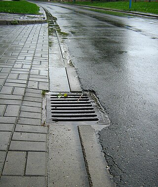
A storm drain, storm sewer, highway drain, surface water drain/sewer, or stormwater drain is infrastructure designed to drain excess rain and ground water from impervious surfaces such as paved streets, car parks, parking lots, footpaths, sidewalks, and roofs. Storm drains vary in design from small residential dry wells to large municipal systems.

The Milwaukee Metropolitan Sewerage District (MMSD) is a regional government agency that provides water reclamation and flood management services for about 1.1 million people in 28 communities in the Greater Milwaukee Area. A recipient of the U.S. Water Prize and many other awards, the District has a record of 98.4 percent, since 1994, for capturing and cleaning wastewater from 28 communities in a 411-square-mile (1,060 km2) area. The national goal is 85 percent of all the rain and wastewater that enters their sewer systems.

A retention basin, sometimes called a retention pond,wet detention basin, or storm water management pond (SWMP), is an artificial pond with vegetation around the perimeter and a permanent pool of water in its design. It is used to manage stormwater runoff, for protection against flooding, for erosion control, and to serve as an artificial wetland and improve the water quality in adjacent bodies of water.

A combined sewer is a type of gravity sewer with a system of pipes, tunnels, pump stations etc. to transport sewage and urban runoff together to a sewage treatment plant or disposal site. This means that during rain events, the sewage gets diluted, resulting in higher flowrates at the treatment site. Uncontaminated stormwater simply dilutes sewage, but runoff may dissolve or suspend virtually anything it contacts on roofs, streets, and storage yards. As rainfall travels over roofs and the ground, it may pick up various contaminants including soil particles and other sediment, heavy metals, organic compounds, animal waste, and oil and grease. Combined sewers may also receive dry weather drainage from landscape irrigation, construction dewatering, and washing buildings and sidewalks.

Rain gardens, also called bioretention facilities, are one of a variety of practices designed to increase rain runoff reabsorption by the soil. They can also be used to treat polluted stormwater runoff. Rain gardens are designed landscape sites that reduce the flow rate, total quantity, and pollutant load of runoff from impervious urban areas like roofs, driveways, walkways, parking lots, and compacted lawn areas. Rain gardens rely on plants and natural or engineered soil medium to retain stormwater and increase the lag time of infiltration, while remediating and filtering pollutants carried by urban runoff. Rain gardens provide a method to reuse and optimize any rain that falls, reducing or avoiding the need for additional irrigation. A benefit of planting rain gardens is the consequential decrease in ambient air and water temperature, a mitigation that is especially effective in urban areas containing an abundance of impervious surfaces that absorb heat in a phenomenon known as the heat-island effect.

Surface runoff is the unconfined flow of water over the ground surface, in contrast to channel runoff. It occurs when excess rainwater, stormwater, meltwater, or other sources, can no longer sufficiently rapidly infiltrate in the soil. This can occur when the soil is saturated by water to its full capacity, and the rain arrives more quickly than the soil can absorb it. Surface runoff often occurs because impervious areas do not allow water to soak into the ground. Furthermore, runoff can occur either through natural or human-made processes.

Sustainable drainage systems are a collection of water management practices that aim to align modern drainage systems with natural water processes and are part of a larger green infrastructure strategy. SuDS efforts make urban drainage systems more compatible with components of the natural water cycle such as storm surge overflows, soil percolation, and bio-filtration. These efforts hope to mitigate the effect human development has had or may have on the natural water cycle, particularly surface runoff and water pollution trends.
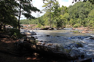
Sweetwater Creek State Park is a 2,549 acres (10.32 km2) Georgia state park in east Douglas County, 15 miles (24 km) from downtown Atlanta. The park is named after Sweetwater Creek which runs through it. Cherokee people were forcibly removed from the area and it eventually became home to the New Manchester Manufacturing Company and mill town of New Manchester. During the American Civil War the textile mill and general store were burned down by the Union Army and the women and children taken away and eventually sent to Louisville, Kentucky and Indiana as refugees.
The Gene Mason Sports Complex is a 55-acre (220,000 m2) sports field park complex located in Cumberland, Maryland. The park was dedicated in 1952 and geared towards organized team sports of baseball, soccer, football, valley ball, tennis, and basketball. A natural vegetation buffer exists along the Potomac River frontage, acting as a stormwater runoff filter and component of the Potomac River Greenway.

Fountain Creek is a creek that originates in Woodland Park in Teller County and flows through El Paso County to its confluence with the Arkansas River near Pueblo in Pueblo County, Colorado. The 74.5-mile-long (119.9 km) creek, once known as the Fontaine qui Bouille, is a tributary of the Arkansas River.
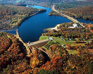
The East Brimfield Dam is located on the Quinebaug River in Sturbridge, Massachusetts, approximately 20 miles (32 km) southwest of Worcester, Massachusetts.

Karkarook Park is a metropolitan park in Melbourne, Victoria, Australia, located at the northwest corner of the southeastern suburb of Heatherton, southeast of the intersection between Warrigal Road and Dingley Bypass, accessible to cars only via Fairchild Street on the south side. The park is a wetland reserve built around the Karkarook Lake, a 15 hectares, 420 m (1,380 ft) wide artificial lake built from a pit created by sand mining between 1997 and 2001, filled in 2004 by groundwater pumped from a bore 500 metres (550 yd) to the southeast.

A sediment control is a practice or device designed to keep eroded soil on a construction site, so that it does not wash off and cause water pollution to a nearby stream, river, lake, or sea. Sediment controls are usually employed together with erosion controls, which are designed to prevent or minimize erosion and thus reduce the need for sediment controls. Sediment controls are generally designed to be temporary measures, however, some can be used for storm water management purposes.

Urban runoff is surface runoff of rainwater, landscape irrigation, and car washing created by urbanization. Impervious surfaces are constructed during land development. During rain, storms, and other precipitation events, these surfaces, along with rooftops, carry polluted stormwater to storm drains, instead of allowing the water to percolate through soil. This causes lowering of the water table and flooding since the amount of water that remains on the surface is greater. Most municipal storm sewer systems discharge untreated stormwater to streams, rivers, and bays. This excess water can also make its way into people's properties through basement backups and seepage through building wall and floors.

A sediment basin is a temporary pond built on a construction site to capture eroded or disturbed soil that is washed off during rain storms, and protect the water quality of a nearby stream, river, lake, or bay. The sediment-laden soil settles in the pond before the runoff is discharged. Sediment basins are typically used on construction sites of 5 acres (20,000 m2) or more, where there is sufficient room. They are often used in conjunction with erosion controls and other sediment control practices. On smaller construction sites, where a basin is not practical, sediment traps may be used.

Boeing Creek is a stream in the U.S. state of Washington, located in the city of Shoreline, just north of Seattle. It is about 1.6 miles (2.6 km) long and empties into Puget Sound. The creek is heavily modified along its course, and in many places has been diverted into culverts. The watershed of Boeing Creek is about 11.2 square miles (29 km2) in size, with two main tributaries aside from the mainstem. The creek takes its name from William Boeing, who built a mansion along the creek in 1913. Despite the river modifications and stormwater pollution, the creek supports a variety of riparian habitats, native animals and fishes.

Historic Fourth Ward Park is a park in the Old Fourth Ward of Atlanta, just south of Ponce City Market and just west of the BeltLine Eastside Trail.

Water-sensitive urban design (WSUD) is a land planning and engineering design approach which integrates the urban water cycle, including stormwater, groundwater, and wastewater management and water supply, into urban design to minimise environmental degradation and improve aesthetic and recreational appeal. WSUD is a term used in the Middle East and Australia and is similar to low-impact development (LID), a term used in the United States; and Sustainable Drainage System (SuDS), a term used in the United Kingdom.
The North Carolina Coastal Federation is a nonprofit organization that works with coastal residents and visitors to protect and restore the beautiful and productive N.C. coast. The four main areas in which the federation operates include: coastal advocacy; environmental education; habitat and water quality restoration and preservation; and support in the improvement and enforcement of environmental laws. The federation headquarters are located in Newport (Ocean), North Carolina, with regional offices in Wanchese and Wrightsville Beach, North Carolina. The federation is currently a member of Restore America's Estuaries (RAE).


