
The Fraser Valley Regional District (FVRD) is a regional district in British Columbia, Canada. Its headquarters are in the city of Chilliwack. The FVRD covers an area of 13,361.74 km² (5,159 sq mi). It was created by an amalgamation of the Fraser-Cheam Regional District and Central Fraser Valley Regional District and the portion of the Dewdney-Alouette Regional District from and including the District of Mission eastwards.
The Chehalis River is located in the southwest corner of British Columbia, Canada near the city of Chilliwack. It flows south-eastward out of the Douglas Ranges of the Coast Mountains, draining into the Harrison River.
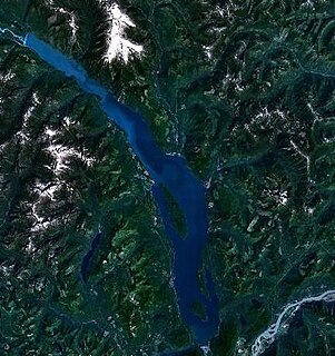
Harrison Lake is the largest lake in the southern Coast Mountains of Canada, being about 250 square kilometres (95 mi²) in area. It is about 60 km (37 mi) in length and at its widest almost 9 km (5.6 mi) across. Its southern end, at the resort community of Harrison Hot Springs, is c. 95 km east of downtown Vancouver. East of the lake are the Lillooet Ranges while to the west are the Douglas Ranges. The lake is the last of a series of large north-south glacial valleys tributary to the Fraser along its north bank east of Vancouver, British Columbia. The others to the west are the Chehalis, Stave, Alouette, Pitt, and Coquitlam Rivers.
The Harrison River is a short but large tributary of the Fraser River, entering it near the community of Chehalis, British Columbia, Canada. The Harrison drains Harrison Lake and is the de facto continuation of the Lillooet River, which feeds the lake.
The Douglas Ranges are a subrange of the Pacific Ranges of the Coast Mountains of the Canadian province of British Columbia, about 70 km (43 mi) east of downtown Vancouver, north of the Fraser River and between the valleys of Stave and Harrison Lakes. They are approximately 4,900 km2 (1,900 sq mi) in area. Their highest peak is Mount Robertson 2,252 m (7,388 ft), at the northwest limit of the range.

Browne Lake Provincial Park is a provincial park in British Columbia, Canada, located 22 km east-southeast of Kelowna in the Okanagan Highland, near Big White Ski Resort and between the heads of Hydraulic and Grouse Creeks.

Duffey Lake Provincial Park is a provincial park in British Columbia, Canada, located at the lake of the same name, which lies along BC Highway 99 just east of the summit of Cayoosh Pass. The lake's inflow and outflow are Cayoosh Creek.
Davis Lake Provincial Park is a provincial park in British Columbia, Canada. It is located east of the southern end of Stave Lake, northeast of Mission, British Columbia. The park's area is c. 185 acres (0.75 km2). There are campgrounds and beaches at the south end of the lake, and the water is warm enough to allow swimming; access is walk-in only. The park features prime bird habitat and a relatively untouched stand of old growth Western Hemlock, as well as a relatively close-up view of Mount Robie Reid.

The District of Kent is a district municipality located 116 kilometres (72 mi) east of Vancouver, British Columbia. Part of the Fraser Valley Regional District, Kent consists of several communities, the largest and most well-known being Agassiz—the only town in the municipality—Harrison Mills, Kilby, Mount Woodside, Kent Prairie, Sea Bird Island and Ruby Creek. Included within the municipality's boundaries are several separately-governed Indian reserves, including the Seabird Island First Nation's reserves on and around the island of the same name.
School District 75 Mission is a school district in the Central Fraser Valley of British Columbia. Centered in Mission, immediately north of Abbotsford, British Columbia, it extends eastward beyond that municipality along the north side of the Fraser River as far as Lake Errock and Deroche.
The Sts'ailes are an indigenous people from the Lower Mainland region of British Columbia, Canada.

Nicomen Mountain, 1,221 m (4,006 ft), is the southernmost major summit of the Douglas Ranges in the Lower Mainland region of southern British Columbia. It is located to the north of Nicomen Island and the communities of Deroche and Lake Errock. A local area Last Spike ceremony was held in 1884 on the Andrew Onderdonk Contract of the Canadian Pacific Railway; Nicomen was the scene of meeting of the two construction crews, one from Hope and one from Port Moody, of the ninety mile stretch through the lower Fraser Valley. The railway has used the mountain extensively for quarrying for gravel ballasting up to the present. Logging and farming continue in the area, though the mountain is still mostly forested.
Deroche is a farming and railway community on the Canadian Pacific Railway and BC Highway 7 located approximately 110 km east of Vancouver, British Columbia, Canada. Deroche is adjacent to the eastern end of Nicomen Island, from which it is separated by the Nicomen Slough. The community is at the foot of Nicomen Mountain and is immediately across the river from Chilliwack Mountain. The population of Deroche is about 148.
Chehalis Lake is a lake on the Chehalis River in the Lower Mainland of southwestern British Columbia, Canada. The lake and the river share the name with the community of Chehalis, British Columbia, which is the home of the Sts'Ailes people, a Halqemeylem-speaking Coast Salish group. Their name Sts'Ailes is said to mean "beating heart"; the similarly named Chehalis, Washington and Chehalis River in that area have a different meaning in the Chehalis language - "sand".
The Scowlitz First Nation or Scowlitz Indian Band is the band government of Skaulits subgroup of the Sto:lo people located on Harrison Bay in the Upper Fraser Valley region between Chehalis (E) and Lake Errock, British Columbia, Canada (W). They are a member government of the Stó:lō Tribal Council.
Harrison Hill (622m) is a small mountain located at the confluence of the Harrison and Fraser Rivers in the Lower Mainland region of British Columbia, Canada. Harrison Knob (~225m) is a prominent shoulder to the east of the main peak of Harrison Hill. Harrison Hill and Harrison Knob are on the north side of the Fraser opposite Chilliwack, Harrison Knob overlooks the confluence directly, Harrison Hill itself separates the Fraser downstream from that confluence and overlooks on its north Harrison Bay, a large, shallow lake-like sidewater of the Harrison River, while at its western foot is the community of Lake Errock. At its eastern foot, just below Harrison Knob, had been the formerly large sawmill town of Harrison Mills, which spanned both sides of the Harrison and was served by the mainline of the Canadian Pacific Railway, which runs along the north side of the mountain's base. The Indian Reserves of the Scowlitz First Nation are at the western end of Harrison Bay and at its outlet at its eastern end, while the reserve of the Chehalis First Nation is along its north shore, and Kilby is on its east shore.
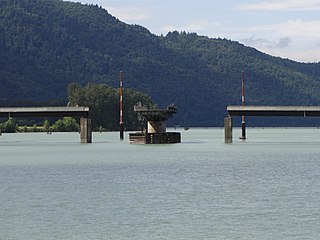
Harrison Bay is a lake-like expansion of the Harrison River, located west of its main course adjacent to the communities of Chehalis and Harrison Mills in the Canadian province of British Columbia. Extremely shallow, the bay outlets to the Fraser at Harrison Mills, where in pre-gold rush times there had been a "riffle", which was dredged to enable easier steamer traffic to Harrison Lake and Port Douglas. The bay has been used as a log sort but is primarily recreational in use today, with the Scowlitz Indian Band running a beach and campground at its western end, on Squawkum Creek Indian Reserve No. 3, which is at the southwest corner of Harrison Bay. Between it and the Fraser lies Harrison Hill, known in Upriver Halkomelem as Qithyll, which is an ancient burial ground currently under investigation by the First Nation in a joint effort with Simon Fraser University's archaeology department.. Adjacent to Kilby Provincial Park and the site of Harrison Mills are Williams Indian Reserve No. 2 and Scowlitz Indian Reserve No. 1

