Related Research Articles

Montana is a state in the Mountain West division of the Western United States. It is bordered by Idaho to the west, North Dakota and South Dakota to the east, Wyoming to the south, and the Canadian provinces of Alberta, British Columbia, and Saskatchewan to the north. It is the fourth-largest state by area, the eighth-least populous state, and the third-least densely populated state. Its state capital is Helena, while the largest city is Billings. The western half of Montana contains numerous mountain ranges, while the eastern half is characterized by western prairie terrain and badlands, with smaller mountain ranges found throughout the state. The state has a reputation for a libertarian bent in popular opinion and policy.

Lake County is a county located in the northwest part of the U.S. state of Montana. As of the 2020 census, the population was 31,134. Its county seat is Polson.

Flathead County is in the U.S. state of Montana. At the 2020 census, its population was 104,357, making it the state's fourth most populous county. Its county seat is Kalispell. Its numerical designation is 7. Its northern border is on the state's north border, making it contiguous with the Canada–US border, facing British Columbia.

Bigfork is a census-designated place (CDP) in Flathead County, Montana, United States. It is within Montana's Rocky Mountains. The population was 4,270 at the 2010 census, up from 1,421 in 2000.
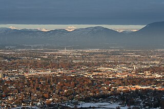
Kalispell is a city in and the county seat of Flathead County, Montana, United States. The 2020 census put Kalispell's population at 24,558. In Montana's northwest region, it is the largest city and the commercial center of the Kalispell Micropolitan Statistical Area. The name Kalispell is a Salish word meaning "flat land above the lake".
Lakeside is an unincorporated area and census-designated place (CDP) in Flathead County, Montana, United States. The population was 2,669 at the 2010 census, up from 1,679 in 2000.

Polson is a city in Lake County, Montana, United States, on the southern shore of Flathead Lake. It is also on the Flathead Indian Reservation. The population was 5,148 at the 2020 census. It is the county seat of Lake County. In 1898 the city was named after pioneer rancher David Polson. It was incorporated in 1910.

The Flathead Indian Reservation, located in western Montana on the Flathead River, is home to the Bitterroot Salish, Kootenai, and Pend d'Oreilles tribes – also known as the Confederated Salish and Kootenai Tribes of the Flathead Nation. The reservation was created through the July 16, 1855, Treaty of Hellgate.

Fort Peck Lake, or Lake Fort Peck, is a major reservoir in Montana, formed by the Fort Peck Dam on the Missouri River. The lake lies in the eastern prairie region of Montana approximately 140 miles (230 km) east of Great Falls and 120 miles (190 km) north of Billings, reaching into portions of six counties.

Flathead Lake is a large natural lake in northwest Montana.

Wild Horse Island, approximately 2,164 acres (876 ha) in size, is the largest island on Flathead Lake, the largest freshwater lake in Montana. Protected as a state park since 1977, the island near Big Arm Bay is home to abundant wildlife including bighorn sheep, mule deer, waterfowl, and bald eagles. It is managed by Montana Fish, Wildlife & Parks and lies within both the Flathead Indian Reservation and Lake County, Montana.

The Flathead National Forest is a national forest in the western part of the U.S. state of Montana. The forest lies primarily in Flathead County, south of Glacier National Park. The forest covers 2,404,935 acres of which about 1 million acres (4,000 km2) is designated wilderness. It is named after the Flathead Native Americans who live in the area.

The Bison Range (BR) is a nature reserve on the Flathead Indian Reservation in western Montana established for the conservation of American bison. Formerly called the National Bison Range, the size of the bison herd at the BR is 350 adult bison and welcomes between 50-60 calves per year. Established as a National Wildlife Refuge in 1908, the BR consists of approximately 18,524 acres (7,496 ha) within the Montana valley and foothill grasslands. The management was transferred back to the Confederated Salish and Kootenai Tribes in 2022 from the U.S. Fish and Wildlife Service after more than a century of federal management and nearly two decades of negotiations.
The Flathead Valley is a region of the U.S. state located in the Northwestern Montana. It includes parts of Flathead County and Lake County. Notable communities include Kalispell, Bigfork, Whitefish, Columbia Falls, Polson, Ronan, and St. Ignatius. The geography of the Flathead roughly corresponds to the valley where Flathead Lake is located, with two distinct ends – the northern Flathead Valley and the southern (lower) Flathead Valley. In addition to Flathead and Whitefish lakes, the area's proximity to attractions such as Glacier National Park, Whitefish Mountain Resort, and Blacktail Mountain Ski Area have made the area a major summer and winter resort destination. Many outdoor activities can be pursued, including hiking, backpacking, boating, rafting, canoeing, skiing, hunting, and fly fishing. The lower Flathead Valley and the southern half of Flathead Lake are within the Flathead Indian Reservation and is home to the historic St. Ignatius Mission, founded in 1854.
The following is an alphabetical list of articles related to the U.S. state of Montana.
The Regional designations of Montana vary widely within the U.S state of Montana. The state is a large geographical area that is split by the Continental Divide, resulting in watersheds draining into the Pacific Ocean, Gulf of Mexico and Hudson's Bay. The state is approximately 545 miles (877 km) east to west along the Canada–United States border and 320 miles (510 km) north to south. The fourth largest state in land area, it has been divided up in official and unofficial ways into a variety of regions. Additionally, Montana is part of a number of larger federal government administrative regions.
Kicking Horse Dam is a dam in Lake County, Montana.
West Shore State Park is a public recreation area occupying 129 acres on the western shore of Flathead Lake five miles south of Lakeside in Lake County, Montana. The state park offers boating, fishing, camping, swimming, hiking, and wildlife viewing.
References
- ↑ "Lake Five". Geographic Names Information System . United States Geological Survey, United States Department of the Interior . Retrieved August 11, 2021.
- 1 2 Cabin Living; Discovering the Simple American Getaway. Lyons Press. 2017. ISBN 9781493030446. LCCN 2017018442.
- ↑ "Lake Five". Montana Fish, Wildlife & Parks. Montana Fish, Wildlife & Parks. Retrieved 24 August 2022.
- ↑ "Fishing access at Lake Five in northwestern Montana proposed". Independent Record . 21 November 2008. Retrieved 24 August 2022– via Newspapers.com.
- ↑ Lake Five Fishbrain
- ↑ Petersen, Chris (30 March 2022). "Court ruling all but shuts down resort on west end of Lake Five". Hungry Horse News. Retrieved 24 August 2022.
Coordinates: 48°27′52″N114°01′12″W / 48.46444°N 114.02000°W
| | This Flathead County, Montana state location article is a stub. You can help Wikipedia by expanding it. |