
Gilmer County is a county in the U.S. state of West Virginia. As of the 2020 census, the population was 7,408, making it West Virginia's fifth-least populous county. Its county seat is Glenville. The county was formed in 1845 from parts of Lewis and Kanawha Counties, and named for Thomas Walker Gilmer, Governor of Virginia from 1840 to 1841. Gilmer was later a representative in the United States Congress and Secretary of the Navy in President John Tyler's cabinet.

Gilmer County is a county located in the north central portion of the U.S. state of Georgia. As of the 2020 census, the population was 31,353. The county seat is Ellijay. It was based on a historic Cherokee town also spelled as Elejoy in the eighteenth century. The county was created on December 3, 1832, and was named for George Rockingham Gilmer, a politician who served two non-consecutive terms as governor of the state. Gilmer County is home of the annual Apple Festival, which is held in mid-October. Ninety percent of the land is in cropland and forest. Poultry raising and processing makes up the largest portion of the agricultural economy, which generates 33.2% of the total revenues. Manufacturing is about 20%.

Gilmer is a city in, and the county seat of, Upshur County, Texas, United States. It is best known for being the home of the East Texas Yamboree and the birthplace of popular music singers Don Henley of the Eagles band and Johnny Mathis, as well as blues musician Freddie King. Its population was 4,843 at the 2020 census.

Nolin River Lake is a reservoir in Edmonson, Grayson, and Hart counties in Kentucky. It was impounded from the Nolin River by the United States Army Corps of Engineers in 1963. The Nolin River dam was authorized in 1938 as part of a flood control act. The lake varies from 2,890 acres (11.7 km2) in the winter to 5,795 acres (23.45 km2) in the summer.

The Chattahoochee–Oconee National Forest in northern Georgia comprises two United States National Forests, the Oconee National Forest in eastern Georgia and the Chattahoochee National Forest located in the North Georgia Mountains. The Chattahoochee National Forest is composed of an eastern and western forest. The western forest contains Johns Mountain, Little Sand Mountain, and Taylor Ridge (Georgia). The combined total area of the Chattahoochee–Oconee National Forest is 867,265 acres (3,510 km2), of which the Chattahoochee National Forest comprises 751,069 acres (3,039 km2) and the Oconee National Forest comprises 116,196 acres (470 km2). The county with the largest portion of the eastern forest is Rabun County, Georgia, which has 148,684 acres (601.7 km2) within its boundaries.

Harriet Hollister Spencer State Recreation Area, also known as the Harriet Hollister Spencer Memorial Recreation Area, is a 1,550-acre (6.3 km2) recreation area and part of the New York state park system. It is located six miles (9.7 km) south of Honeoye, off Canadice Hill Road in the south part of the Town of Canadice in Ontario County, New York.
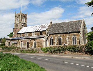
Watlington is a village, civil parish and electoral ward in the English county of Norfolk. It covers an area of 6.93 km2 (2.68 sq mi) and had a population of 2,031 in 852 households at the 2001 census, the population increasing to 2,455 at the 2011 Census. It is in the district of King's Lynn and West Norfolk.
Sønningen is a lake in the municipality of Levanger in Trøndelag county, Norway. The 0.86 km2 (210-acre) lake lies about 2.5 km (1.6 mi) southwest of the village of Ekne, about 2 km (1.2 mi) west of the lake Byavatnet, and about 2.3 kilometres (1.4 mi) southeast of the shore of the Trondheimsfjorden.
The Suncook Lakes are a pair of lakes located in Belknap County in central New Hampshire, United States, in the town of Barnstead. Upper Suncook Lake encompasses 402 acres (1.63 km2), while Lower Suncook Lake covers 295 acres (1.19 km2). The lakes are connected by a 1,000-foot-long (300 m) channel, spanned by a road bridge. A dam at the outlet of Lower Suncook Lake controls the water level of both lakes. The lakes are located along the Suncook River, a tributary of the Merrimack River. There are three islands on Lower Lake.
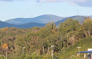
The Rich Mountain Wilderness is a wilderness area within the Chattahoochee National Forest in Gilmer County, Georgia, in the United States. It was designated in 1986 and currently consists of 9,476 acres (38.35 km2) of the 13,276 acres (54 km2) that makes up the Rich Mountains. The Wilderness is managed by the United States Forest Service and is part of the National Wilderness Preservation System.

The Cartecay River is a 19.1-mile-long (30.7 km) river that runs into Ellijay, Georgia, in Gilmer County. It is the site of a class II whitewater run.
Lucky Lake is a village in the Canadian province of Saskatchewan within the Rural Municipality of Canaan No. 225 and Census Division No. 7. The Village is located at the junction of Highway 42, Highway 45 and Highway 646 approximately 90 km northeast of Swift Current, Saskatchewan.
The Tamarac Wilderness is a 2,180-acre (9 km2) wilderness area in the U.S. state of Minnesota. Established by the United States Congress in 1976, Tamarac Wilderness is composed primarily of small lakes, wooded potholes, bogs and marshes. The wilderness consists of four sections of the 42,724-acre (173 km2) Tamarac National Wildlife Refuge: three islands in Tamarac Lake totaling about 65 acres (0 km2) in the southwest section, and more than 2,180 acres (9 km2) in the northwest corner.

Carters Lake is a man-made reservoir located on the Coosawattee River in the Blue Ridge Mountains in Gilmer and Murray counties in the U.S. state of Georgia. It is the state's deepest lake.

Northeast Georgia is a region of Georgia in the United States. The northern part is also in the North Georgia mountains or Georgia mountain region, while the southern part is still hilly but much flatter in topography. Northeast Georgia is also served by the Asheville/Spartanburg/Greenville/Anderson market.
Gilmer is an unincorporated community in Lake County, Illinois, United States. Gilmer is located along Gilmer Road and the Canadian National Railway north of Hawthorn Woods.
The Cold Fire was a wildfire that started on August 2, 2016, in the Vaca Mountains, near Lake Berryessa and just west of the city of Winters, in Yolo County, northern California. The fire was contained by 6 PM on August 11 after burning a total of 5,371 acres (21.74 km2), including two buildings, causing an estimated $100,000 in damage.
Partridge Lake is a lake located in Waupaca County, Wisconsin. It has a surface area of 1,185 acres and a max depth of 4 ft (1.2 m). The Wolf River is the primary source for the lake, with the Little River and the Walla Walla Creek also emptying into the lake. The village of Fremont lies on the south shore.


