
The Victorian government's Wimmera Southern Mallee subregion is part of the Grampians region in western Victoria. It includes most of what is considered the Wimmera, and part of the southern Mallee region. The subregion is based on the social catchment of Horsham, its main settlement.

The Thomson River is a perennial river that forms part of the Lake Eyre Basin, situated in the central west and western regions of Queensland, Australia. Much of the course of the river comprises a series of narrow channels synonymous with the Channel Country and the Galilee subregion.

The Wheatbelt is one of nine regions of Western Australia defined as administrative areas for the state's regional development, and a vernacular term for the area converted to agriculture during colonisation. It partially surrounds the Perth metropolitan area, extending north from Perth to the Mid West region, and east to the Goldfields–Esperance region. It is bordered to the south by the South West and Great Southern regions, and to the west by the Indian Ocean, the Perth metropolitan area, and the Peel region. Altogether, it has an area of 154,862 square kilometres (59,793 sq mi).

The Mallee is a sub-region of Loddon Mallee covering the most north-westerly part of Victoria, Australia and is bounded by the South Australian and New South Wales borders. Definitions of the south-eastern boundary vary, however, all are based on the historic Victorian distribution of mallee eucalypts. These trees dominate the surviving vegetation through most of Mallee,. Its biggest settlements are Mildura and Swan Hill.

Newdegate is a townsite in the Great Southern agricultural region, 399 km south-east of Perth and 52 km east of Lake Grace in Western Australia. The townsite was gazetted in 1925 and honours Sir Francis Newdegate, the Governor of Western Australia from 1920 to 1924. The Department of Agriculture and Food operates one of its 13 research stations in the area of Newdegate.

Esperance Plains, also known as Eyre Botanical District, is a biogeographic region in southern Western Australia on the south coast between the Avon Wheatbelt and Hampton bioregions, and bordered to the north by the Mallee region. It is a plain punctuated by granite and quartz outcrops and ranges, with a semi-arid Mediterranean climate and vegetation consisting mostly of mallee-heath and proteaceous scrub. About half of the region has been cleared for intensive agriculture. Recognised as a bioregion under the Interim Biogeographic Regionalisation for Australia (IBRA), it was first defined by John Stanley Beard in 1980.

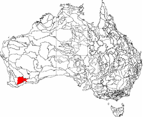
Mallee, also known as Roe Botanical District, is a biogeographic region in southern Western Australia. Located between the Esperance Plains, Avon Wheatbelt and Coolgardie bioregions, it has a low, gently undulating topography, a semi-arid mediterranean climate, and extensive Eucalyptus mallee vegetation. It has an area of 73,975.59 square kilometres (28,562.13 sq mi). About half of the region has been cleared for intensive agriculture. Recognised as a region under the Interim Biogeographic Regionalisation for Australia (IBRA), it was first defined by John Stanley Beard in 1980.
Muehlenbeckia horrida subsp. abdita. commonly known as remote thorny lignum, is a critically endangered shrub endemic to Western Australia.
Lake Bryde-East Lake Bryde is a DIWA-listed freshwater wetland system located in the Great Southern region of Western Australia. The system consists of two lakes: Lake Bryde, with an area of 50 hectares ; and East Lake Bryde, with an area of about 1.4 square kilometres (0.54 sq mi). They are located at the head of a chain of lakes that extend to Lake Magenta, and ultimately form part of the Swan-Avon drainage system.

Lake Grace South, part of the Lake Grace System, is a wetland located in the Great Southern region of Western Australia. Situated in the Shire of Kent, the lake is part of the Western Mallee subregion of the Mallee region. It has an area of about 56 square kilometres (22 sq mi). It is one of four lakes in the area comprising a DIWA-listed wetland of national importance.
Lake Altham, part of the Lake Grace System, is a wetland located in the Great Southern region of Western Australia. Situated in the Shire of Kent, the lake is part of the Western Mallee subregion of the Mallee region. It has an area of about 2.4 square kilometres (0.93 sq mi) and is one of four lakes in the area comprising a DIWA-listed wetland of national importance.
Lake Grace System is a DIWA-listed wetland in Western Australia. Located on the border of the Shires of Lake Grace and Kent, it consists of four lakes, Lake Grace North, Lake Grace South, Lake Altham and Cemetery Lake. It has an area of about 132 km2 (51 sq mi).
Western Mallee is an Interim Biogeographic Regionalisation for Australia (IBRA) subregion in southern Western Australia. It is a sparsely populated subregion with an area of about 47,000 square kilometres, roughly centred on the town of Newdegate. Largely cleared for intensive agriculture, it still retains patches of native vegetation, but these are under environmental stress from threats such as rising salinity, and are poorly managed.

Eastern Mallee is an Interim Biogeographic Regionalisation for Australia (IBRA) subregion in southern Western Australia.

Hampton is an interim Australian bioregion located in southeastern coastal Western Australia, with a small portion (4%) extending into adjacent South Australia. It has an area of 1,088,198 hectares. The Hampton bioregion is part of the Coolgardie woodlands ecoregion.
Lake Annean, sometimes referred to as Annean Lake or incorrectly as Nannine Lake, is a DIWA-listed salt lake system located in the Mid West region of Western Australia. The lake is situated about 40 kilometres (25 mi) southwest of Meekatharra.
Lake Warden is a salt lake in the Goldfields-Esperance region of Western Australia. It and its associated wetlands are protected in a nature reserve; they were recognised as being of international importance under the Ramsar Convention through designation of the Lake Warden System on 7 June 1990 as Ramsar Site 485. The lake is also a DIWA-listed wetland.
In South Australia, one of the states of Australia, there are many areas which are commonly known by regional names. Regions are areas that share similar characteristics. These characteristics may be natural such as the Murray River, the coastline, desert or mountains. Alternatively, the characteristics may be cultural, such as common land use. South Australia is divided by numerous sets of regional boundaries, based on different characteristics. In many cases boundaries defined by different agencies are coterminous.


