
A cave or cavern is a natural void under the Earth's surface. Caves often form by the weathering of rock and often extend deep underground. Exogene caves are smaller openings that extend a relatively short distance underground. Caves which extend further underground than the opening is wide are called endogene caves.

A sinkhole is a depression or hole in the ground caused by some form of collapse of the surface layer. The term is sometimes used to refer to doline, enclosed depressions that are also known as shakeholes, and to openings where surface water enters into underground passages known as ponor, swallow hole or swallet. A cenote is a type of sinkhole that exposes groundwater underneath. Sink, and stream sink are more general terms for sites that drain surface water, possibly by infiltration into sediment or crumbled rock.

Hạ Long Bay or Halong Bay is a UNESCO World Heritage Site and popular travel destination in Quảng Ninh province, Vietnam. The name Hạ Long means "descending dragon". Administratively, the bay belongs to Hạ Long city, Cẩm Phả city, and is a part of Vân Đồn district. The bay features thousands of limestone karsts and islets in various shapes and sizes. Hạ Long Bay is a center of a larger zone that includes Bai Tu Long Bay to the northeast, and Cát Bà Island to the southwest. These larger zones share a similar geological, geographical, geomorphological, climate, and cultural characters.

An underwater environment is a environment of, and immersed in, liquid water in a natural or artificial feature, such as an ocean, sea, lake, pond, reservoir, river, canal, or aquifer. Some characteristics of the underwater environment are universal, but many depend on the local situation.

Tsumeb is a city of around 35,000 inhabitants and the largest town in the Oshikoto region in northern Namibia. Tsumeb is known as the "gateway to the north" of Namibia. It is the closest town to the Etosha National Park. Tsumeb used to be the regional capital of Oshikoto until 2008, when Omuthiya was proclaimed a town and the new capital. The area around Tsumeb forms its own electoral constituency and has a population of 44,113. The town is the site of a deep mine that in its heyday was known as "TCL", but has since been renamed the Ongopolo Mine.

Dos Ojos is part of a flooded cave system located north of Tulum, on the Caribbean coast of the Yucatán Peninsula, in the state of Quintana Roo, Mexico. The exploration of Dos Ojos began in 1987 and still continues. The surveyed extent of the cave system is 82 kilometers (51 mi) and there are 28 known sinkhole entrances, which are locally called cenotes. In January 2018, a connection was found between Sistema Dos Ojos and Sistema Sac Actun. The smaller Dos Ojos became a part of Sac Actun, making the Sistema Sac Actun the longest known underwater cave system in the world.
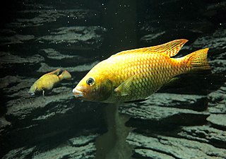
The Otjikoto tilapia is a critically endangered species of cichlid fish endemic to Namibia where it was originally only found in Lake Guinas. This very small sinkhole lake contains quite clear water that generally ranges between 18 and 25 °C depending on season, and the Otjikoto tilapia has been seen down to depths of 67 m (220 ft). Despite deriving its common name from the nearby Lake Otjikoto, it in not native to that lake, rather being an introduced species. It is rare in the aquarium trade and also kept in garden ponds in southern Africa.

An underground lake is a lake underneath the surface of the Earth. Most naturally occurring underground lakes are found in areas of karst topography, where limestone or other soluble rock has been weathered away, leaving a cave where water can flow and accumulate.

Piccaninnie Ponds Conservation Park, formerly the Piccaninnie Ponds National Park, is a protected area of 862 hectares located in southeastern South Australia near Mount Gambier.

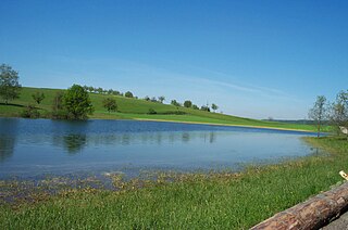
Otjikoto Lake is the smaller of only two permanent natural lakes in Namibia. It is a sinkhole lake that was created by a collapsing karst cave. It is located 20 kilometres (12 mi) north-west of Tsumeb and only 100 meters from the main road B1. The lake was declared a national monument in 1972.
Stone Aerospace is an aerospace engineering firm founded by engineer and explorer Bill Stone, located in Del Valle, a suburb of Austin, Texas.
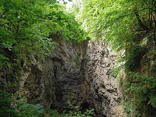
Hranice Abyss is the deepest flooded pit cave in the world. It is a karst sinkhole near the town of Hranice, Czech Republic. The greatest confirmed depth is 519.5 m (1,704 ft), of which 450 m (1,476 ft) is underwater. In 2020, a scientific expedition to the cave revealed that part of the system apparently reaches 1,000 metres (3,300 ft) deep, albeit with the lowest reaches sediment-filled. Analysis of the water found carbon and helium isotopes which implied that the cave has been formed by acidic waters, heated by the mantle, welling up from below.

Dragon's Breath Cave is a flooded karst cave located in the Otjozondjupa Region of Namibia on private land, not accessible to the general public. The cave was discovered by Roger Ellis during a caving expedition to the area in 1986. It is named for the warm moist air that rises from its entrance when barometric pressure drops, which condenses to form a mist suggestive of the breath of a dragon.
Namibia, a country in south-western Africa, has a total of 124 known caves, 41 of which are situated in the Otjozondjupa Region.
Little Blue Lake is a water-filled sinkhole (“cenote”) in the Australian state of South Australia located in the state's south-east in the locality of Mount Schank about 20 kilometres (12 mi) south of the municipal seat of Mount Gambier. It is notable locally as a swimming hole and nationally as a cave diving site. It is managed by the District Council of Grant and has been developed as a recreational and tourism venue.

Fossil Cave (5L81), formerly known as The Green Waterhole, is a cave in the Limestone Coast region of south-eastern South Australia. It is located in the gazetted locality of Tantanoola about 22 kilometres north-west of the city of Mount Gambier, only a few metres from the Princes Highway between Mount Gambier and Millicent. It is popular with cave divers and is notable for being both a unique paleontological site and the "type locality" for very rare crustaceans which to date have been found only in caves and Blue Lake in the Mount Gambier region.
Karst lakes are formed as the result of a collapse of caves, especially in water-soluble rocks such as limestone, gypsum and dolomite. This process is known as karstification. They can cover areas of several hundred square kilometres. Their shallow lakebed is usually an insoluble layer of sediment so that water is impounded, leading to the formation of lakes. Many karst lakes only exist periodically, but return regularly after heavy rainfall.
The Wonderfonteinspruit is a small river situated in the Highveld region of South Africa. Its source has been disputed in the past, although it is now accepted that the river originates in the West Rand of Gauteng between Krugersdorp and Randfontein, at the Tudor Dam, which was initially used as a storage dam for the Luiperdsvlei Gold Plant. In the past the river received a majority of its water from karst springs along its course. The river flows through one of the richest gold-producing areas in the world, which led to the dolomitic compartments which fed the river being dewatered to make way for mining activities. This led to the drying up of the karst springs that fed the river.

Cave diving is underwater diving in water-filled caves. The equipment used varies depending on the circumstances, and ranges from breath hold to surface supplied, but almost all cave diving is done using scuba equipment, often in specialised configurations with redundancies such as sidemount or backmounted twinset. Recreational cave diving is generally considered to be a type of technical diving due to the lack of a free surface during large parts of the dive, and often involves planned decompression stops. A distinction is made by recreational diver training agencies between cave diving and cavern diving, where cavern diving is deemed to be diving in those parts of a cave where the exit to open water can be seen by natural light. An arbitrary distance limit to the open water surface may also be specified. Despite the risks, water-filled caves attract scuba divers, cavers, and speleologists due to their often unexplored nature, and present divers with a technical diving challenge.

