Lake Henry (Bon Homme County, South Dakota)

Last updated
Lake Henry
Location Bon Homme County, South Dakota, United States
Coordinates 43°08′35″N97°42′05″W / 43.1431319°N 97.7014388°W / 43.1431319; -97.7014388 Coordinates: 43°08′35″N97°42′05″W / 43.1431319°N 97.7014388°W / 43.1431319; -97.7014388
Lake type Reservoir
Primary inflows Dawson Creek
Primary outflows Dawson Creek
Basin  countries United States
Surface area 113 acres (46 ha)
Average depth 6.6 ft (2.0 m) [1]
Shore length1 7 mi (11 km)
Surface elevation 1,290 ft (390 m) msl
References U.S. Geological Survey Geographic Names Information System: Lake Henry (Bon Homme County, South Dakota)
1 Shore length is not a well-defined measure.

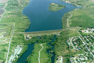
Lake Henry is a small artificial lake formed by the construction of a dam across Dawson Creek (South Dakota) in Bon Homme County, South Dakota, United States, about 0.75 mi (1.21 km) east of the town of Scotland.

Lake A body of relatively still water, in a basin surrounded by land

A lake is an area filled with water, localized in a basin, that is surrounded by land, apart from any river or other outlet that serves to feed or drain the lake. Lakes lie on land and are not part of the ocean, and therefore are distinct from lagoons, and are also larger and deeper than ponds, though there are no official or scientific definitions. Lakes can be contrasted with rivers or streams, which are usually flowing. Most lakes are fed and drained by rivers and streams.

Dam A barrier that stops or restricts the flow of surface or underground streams

A dam is a barrier that stops or restricts the flow of water or underground streams. Reservoirs created by dams not only suppress floods but also provide water for activities such as irrigation, human consumption, industrial use, aquaculture, and navigability. Hydropower is often used in conjunction with dams to generate electricity. A dam can also be used to collect water or for storage of water which can be evenly distributed between locations. Dams generally serve the primary purpose of retaining water, while other structures such as floodgates or levees are used to manage or prevent water flow into specific land regions. The earliest known dam is the Jawa Dam in Jordan, dating to 3,000 BC.

Bon Homme County, South Dakota County in the United States

Bon Homme County is a county in the U.S. state of South Dakota. As of the 2010 United States Census, the population was 7,070. Its county seat is Tyndall.

The lake is within the James River watershed. The lake was named in honor of State Senator Henry Brown of Bon Homme County. The original dam was constructed in 1937. By the late 1980s, however, decades of erosion had degraded the lake and use had declined considerably. Plans to renovate the lake began in 1991 after extensive damage to the spillway was discovered. In 1994, the dam was breached and the lake drained to allow spillway repairs and the removal of accumulated sediments. The renovation project quickly ground to a halt when funding was withdrawn and the lake remained dry for nearly a decade. In 2002, funding for the project was restored. It was determined more economical to build a new dam rather than rebuild the old one. A new site was chosen ⅜ of a mile downstream and construction began late in 2002. The dam was completed in 2003 and completely filled with water in 2005. [2]

James River (Dakotas) river in North and South Dakota, US

The James River is a tributary of the Missouri River, approximately 710 miles (1,140 km) long, draining an area of 20,653 square miles (53,490 km2) in the U.S. states of North Dakota and South Dakota. About 70 percent of the drainage area is in South Dakota. The river provides the main drainage of the flat lowland area of the Dakotas between the two plateau regions known as the Coteau du Missouri and the Coteau des Prairies. This narrow area was formed by the James lobe of the Laurentide Ice Sheet during the last ice age, and as a consequence the watershed of the river is slender and it has few major tributaries for a river of its length.

Drainage basin Area of land where precipitation collects and drains off into a common outlet

A drainage basin is any area of land where precipitation collects and drains off into a common outlet, such as into a river, bay, or other body of water. The drainage basin includes all the surface water from rain runoff, snowmelt, and nearby streams that run downslope towards the shared outlet, as well as the groundwater underneath the earth's surface. Drainage basins connect into other drainage basins at lower elevations in a hierarchical pattern, with smaller sub-drainage basins, which in turn drain into another common outlet.

Spillway structure for controlled release of flows from a dam or levee

A spillway is a structure used to provide the controlled release of flows from a dam or levee into a downstream area, typically the riverbed of the dammed river itself. In the United Kingdom, they may be known as overflow channels. Spillways ensure that the water does not overflow and damage or destroy the dam.

The lake is popular for fishing and recreation in the area. The lake is stocked by the South Dakota Department of Game, Fish, and Parks. Fish Species found at Lake Henry include: Largemouth Bass, Yellow Perch, Channel Catfish, Black Crappie, Bluegill, Black Bullhead, Green Sunfish, Hybrid Sunfish, White Sucker, and Carp. There is a boat ramp with dock on southeast corner with public restrooms. There are two handicapped accessible fishing piers. The entire lake is designated a "no wake zone". [2]

Fishing Activity of trying to catch fish

Fishing is the activity of trying to catch fish. Fish are normally caught in the wild. Techniques for catching fish include hand gathering, spearing, netting, angling and trapping. “Fishing” may include catching aquatic animals other than fish, such as molluscs, cephalopods, crustaceans, and echinoderms. The term is not normally applied to catching farmed fish, or to aquatic mammals, such as whales where the term whaling is more appropriate. In addition to being caught to be eaten, fish are caught as recreational pastimes. Fishing tournaments are held, and caught fish are sometimes kept as preserved or living trophies. When bioblitzes occur, fish are typically caught, identified, and then released.

Recreation activity of leisure

Recreation is an activity of leisure, leisure being discretionary time. The "need to do something for recreation" is an essential element of human biology and psychology. Recreational activities are often done for enjoyment, amusement, or pleasure and are considered to be "fun".

Fish stocking

Fish stocking is the practice of raising fish in a hatchery and releasing them into a river, lake, or ocean to supplement existing populations or to create a population where none exists. Stocking may be done for the benefit of commercial, recreational, or tribal fishing, but may also be done to restore or increase a population of threatened or endangered fish in a body of water closed to fishing.

See also

Related Research Articles

Yankton County, South Dakota County in the United States

Yankton County is a county in the U.S. state of South Dakota. As of the 2010 United States Census, the population was 22,438. Its county seat is Yankton. Yankton County comprises the Yankton, SD Micropolitan Statistical Area.

Lake Travis reservoir

Lake Travis is a reservoir on the Colorado River in central Texas in the United States. The reservoir was formed in 1942 by the construction of Mansfield Dam on the western edge of Austin, Texas by the Lower Colorado River Authority (LCRA), and was built specifically to contain floodwaters in a flash-flood prone region. During its construction, after a severe flood in July 1938, the height of the dam was raised to add storage capacity for floodwaters.

Hume Dam dam in Australia

Hume Dam, formerly the Hume Weir, is a major dam across the Murray River downstream of its junction with the Mitta River in the Riverina region of New South Wales, Australia. The dam's purpose includes flood mitigation, hydro-power, irrigation, water supply and conservation. The impounded reservoir is called Lake Hume, formerly the Hume Reservoir. It is a gated concrete gravity dam with four earth embankments and twenty-nine vertical undershot gated concrete overflow spillways.

Garrison Dam embankment dam

Garrison Dam is an earth-fill embankment dam on the Missouri River in central North Dakota, U.S.. Constructed by the U.S. Army Corps of Engineers from 1947 to 1953, at over 2 miles (3.2 km) in length, the dam is the fifth-largest earthen dam in the world. The reservoir impounded by the dam is Lake Sakakawea, which extends to Williston and the confluence with the Yellowstone River, near the Montana border.

Oroville Dam earthfill embankment dam in Oroville, California

Oroville Dam is an earthfill embankment dam on the Feather River east of the city of Oroville, California, in the Sierra Nevada foothills east of the Sacramento Valley. At 770 feet (235 m) high, it is the tallest dam in the U.S. and serves mainly for water supply, hydroelectricity generation and flood control. The dam impounds Lake Oroville, the second largest man-made lake in the state of California, capable of storing more than 3.5 million acre feet.

Oahe Dam

The Oahe Dam is a large earthen dam on the Missouri River, just north of Pierre, South Dakota, United States. The dam creates Lake Oahe, the fourth largest man-made reservoir in the United States. The reservoir stretches 231 miles (372 km) up the course of the Missouri to Bismarck, North Dakota. The dam's power plant provides electricity for much of the north-central United States. It is named for the Oahe Indian Mission established among the Lakota Sioux in 1874.

Lake Berryessa reservoir

Lake Berryessa is the largest lake in Napa County, California. This reservoir in the Vaca Mountains was formed following the construction of the Monticello Dam in the 1950's. Since the early 1960's, this reservoir has provided water and hydroelectricity to the North Bay region of the San Francisco Bay Area.

Lake Sabbatia lake of the United States of America

Lake Sabbatia, sometimes known as Scaddings Pond is a 248-acre great pond in Taunton, Massachusetts, near Watson Pond State Park. The lake is where Mill River begins and the Snake River ends. It is the largest lake in the city of Taunton and the most popularly used. There are several coves and an island within the lake. Parts of its coastline arepopulated with woods, streets, and residential homes. Lake Sabbatia is used for a variety of recreational activities such as boating, swimming, fishing, and ice fishing. There is a boat ramp off Bay Street into the lake.

Somerset Dam

The Somerset Dam is a mass concrete gravity dam with a gated spillway across the Stanley River in Queensland, Australia. It is within the locality of Somerset Dam in the Somerset Region in South East Queensland. The main purpose of the dam is the supply of potable water for the Brisbane, Gold Coast and Logan City regions. Additionally, the dam provides for flood mitigation, recreation and for the generation of hydroelectricity. The impounded reservoir is called Lake Somerset.

Gavins Point Dam

Gavins Point Dam is a 1.9 mi (3 km) long embankment rolled-earth and chalk-fill dam which spans the Missouri River and impounds Lewis and Clark Lake. The dam joins Cedar County, Nebraska with Yankton County, South Dakota a distance of 811.1 river miles upstream of St. Louis, Missouri, where the river joins the Mississippi River. The dam and hydroelectric power plant were constructed as the Gavins Point Project from 1952 to 1957 by the United States Army Corps of Engineers as part of the Pick-Sloan Plan. The dam is located approximately 4 miles west or upstream of Yankton, South Dakota.

Lewis and Clark Lake

Lewis and Clark Lake is a 31,400 acre (130 km²) reservoir located on the border of the U.S. States of Nebraska and South Dakota on the Missouri River. The lake is approximately 25 miles (40 km) in length with over 90 miles (140 km) of shoreline and a maximum water depth of 45 feet (14 m). The lake is impounded by Gavins Point Dam and is managed by the U.S. Army Corps of Engineers, Omaha District.

Grafton Pond lake of the United States of America

Grafton Pond is a 319-acre (1.3 km2) water body located in Grafton County in western New Hampshire, United States, in the town of Grafton. The pond is part of the Mascoma River watershed, flowing to the Connecticut River. Outflow from the pond travels through Bicknell Brook to Crystal Lake in Enfield, then north to the Mascoma River in West Canaan.

Lake Altus-Lugert lake of the United States of America

Lake Altus-Lugert, also known as Lake Altus and Lake Lugert is a reservoir located on the North Fork Red River, about 17 miles (27 km) north of Altus, Oklahoma on the former site of the town of Lugert, Oklahoma. The river is the boundary between Greer County and Kiowa County, Oklahoma. The lake is used for fishing, boating, swimming, and irrigation. However, toxic blooms of golden algae killed off nearly all adult fish early in 2013, making it unsuitable for fishing, temporarily. Heavy rains in 2015 ended an 8-year drought and refilled the lake with water. This is also the principal water supply for Altus.

Jamestown Dam

The Jamestown Dam is a rolled-earth dam spanning the James River in Stutsman County in the U.S. state of North Dakota, serving the primary purpose of flood control. It is north of the city of Jamestown, North Dakota. Built from April 1952 to September 1953, the dam measures 1,418 feet (432 m) long at the crest and 85 feet (26 m) high. It impounds the James River to form the Jamestown Reservoir. A small islet lies shortly upstream of the dam, where the James River previously split into two channels.

Angostura Reservoir

Angostura Reservoir is a reservoir on the Cheyenne River in Fall River County, South Dakota, United States. It was created after the construction of Angostura Dam in 1949 for irrigation by the U.S. Bureau of Reclamation. "Angostura" means "narrows" in Spanish.

Pactola Dam

Pactola Dam is an embankment dam on Rapid Creek in Pennington County, South Dakota, about 10 miles (16 km) west of Rapid City. The dam was completed in 1956 by the U.S. Bureau of Reclamation to provide flood control, water supply and recreation. Along with the nearby Deerfield Dam, it is part of the Rapid Valley Unit of the Pick-Sloan Missouri Basin Program. U.S. Route 385 runs along the crest of the dam. The dam forms Pactola Lake, which at over 1,200 acres (490 ha) is the largest and deepest body of water in the Black Hills.

Lake Yankton (South Dakota)

Lake Yankton, also called Cottonwood Lake, is an artificial lake that was originally part of the main channel of the Missouri River on the border of the U.S. States of Nebraska and South Dakota, near Yankton, South Dakota. The lake has an approximate surface area of 250 acres (100 ha) and has a maximum depth of 18 feet (5.5 m). The lake is located immediately downstream (east) of Gavins Point Dam and Lewis and Clark Lake, located just north of the current location of the main channel of the Missouri River.

Lake Byllesby (Cannon River) reservoir on the Cannon River in Minnesota, United States

Lake Byllesby is a 1,432-acre artificial lake on the Cannon River in Dakota and Goodhue counties, in the U.S. State of Minnesota. The lake was formed as a result of construction of the Byllesby Dam by the H.M. Byllesby & Company, which would later become Northern States Power Company for hydroelectric power generation. Today, the lake serves as a popular recreational destination and is the largest lake in Southern Dakota County, approximately 30 miles (48 km) southeast of the Twin Cities.

Springfield Recreation Area

Springfield Recreation Area is a state recreation area in Bon Homme County, South Dakota in the United States. The recreation area is located on the upper part of Lewis and Clark Lake, and is popular for boating, fishing, and hunting. There is a 20-site campground and a boat launch to access the lake and the Missouri River. The area is about 30 miles west of Yankton.

References

  1. "Lake Henry". lake-link.com. Retrieved 17 April 2018.
  2. 1 2 "Fishing". www.scotlandsd.org. Retrieved 17 April 2018.