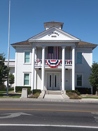
Churchill County is a county in the western U.S. state of Nevada. As of the 2020 census, the population was 25,516. Its county seat is Fallon. Named for Mexican–American War hero brevet Brigadier General Sylvester Churchill, the county was formed in 1861. Churchill County comprises the Fallon, NV Micropolitan Statistical Area. It is in northwestern Nevada. Churchill County is noteworthy in that it owns and operates the local telephone carrier, Churchill County Communications.

Humboldt County is a county in the U.S. state of Iowa. As of the 2020 census, the population was 9,597. The county seat is Dakota City. The county was created in 1857 and named in honor of Alexander von Humboldt.

The Truckee River is a river in the U.S. states of California and Nevada. The river flows northeasterly and is 121 miles (195 km) long. The Truckee is the sole outlet of Lake Tahoe and drains part of the high Sierra Nevada, emptying into Pyramid Lake in the Great Basin. Its waters are an important source of irrigation along its valley and adjacent valleys.

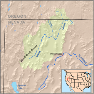
The Humboldt River is an extensive river drainage system located in north-central Nevada. It extends in a general east-to-west direction from its headwaters in the Jarbidge, Independence, and Ruby Mountains in Elko County, to its terminus in the Humboldt Sink, approximately 225 direct miles away in northwest Churchill County. Most estimates put the Humboldt River at 300 to 330 miles long however, due to the extensive meandering nature of the river, its length may be more closely estimated at 380 miles (610 km). It is located within the Great Basin Watershed and is the third longest river in the watershed behind the Bear River at 355 miles (571 km) and the Sevier River at 325 miles (523 km). The Humboldt River Basin is the largest sub-basin of the Great Basin encompassing an area of 16,840 square miles (43,600 km2). It is the only major river system wholly contained within the state of Nevada.

The Humboldt Sink is an intermittent dry lake bed, approximately 11 mi (18 km) long, and 4 mi (6 km) across, in northwestern Nevada in the United States. The body of water in the sink is known as Humboldt Lake. The sink and its surrounding area was a notorious and dreaded portion of overland travel to California during the westward migrations of the mid-1800s, which were largely undertaken along the California Trail.

The West Humboldt Range is a short mountain range in the western Great Basin in northwestern Nevada in the United States.

The Walker River is a river in west-central Nevada in the United States, approximately 62 miles (100 km) long. Fed principally by snowmelt from the Sierra Nevada of California, it drains an arid portion of the Great Basin southeast of Reno and flows into the endorheic basin of Walker Lake. The river is an important source of water for irrigation in its course through Nevada; water diversions have reduced its flow such that the level of Walker Lake has fallen 160 feet (49 m) between 1882 and 2010. The river was named for explorer Joseph Reddeford Walker, a mountain man and experienced scout who is known for establishing a segment of the California Trail.
The Kings River is a tributary of the Quinn River, about 40 mi (64 km) long, in northwestern Nevada and south-central Oregon in the United States. It drains a remote arid area of the northwestern Great Basin.

Imlay is an unincorporated town in Pershing County, Nevada, United States. It has an elementary school, a general store, a post office, and a trading post. As of the 2010 census the population was 171.

The Calico Hills or Calico Mountains are a mountain range in northwestern Nevada. The range runs north to south along the western edge of the Black Rock Desert. This mountain range is located in western Humboldt County and the northwestern corner of Pershing County, approximately 30 miles north of the town of Gerlach, Nevada. The best access to the Calico Hills is located from the maintained Soldier Meadows Road that forms its eastern boundary.

The Lahontan Valley is a basin in Churchill County, Nevada, United States. The valley is a landform of the central portion of the prehistoric Lake Lahontan's lakebed of 20,000-9,000 years ago. The valley and the adjacent Carson Sink represent a small portion of the lake bed. Humboldt Lake is to the valley's northeast. Pyramid Lake is west. Walker Lake is to the south. The valley is part of the larger Great Basin Desert, however during the California Gold Rush the valley was often called the Forty Mile Desert.

The landlocked U.S. state of Nevada has a varied geography and is almost entirely within the Basin and Range Province and is broken up by many north–south mountain ranges. Most of these ranges have endorheic valleys between them.

The Humboldt Salt Marsh in the Humboldt Sink of northwestern Nevada is a wetland that is 1 of 2 salt marshes within the state. It is protected within the Humboldt Wildlife Management Area.

An endorheic lake is a collection of water within an endorheic basin, or sink, with no evident outlet. Endorheic lakes are generally saline as a result of being unable to get rid of solutes left in the lake by evaporation. These lakes can be used as indicators of anthropogenic change, such as irrigation or climate change, in the areas surrounding them. Lakes with subsurface drainage are considered cryptorheic.

The Carson Desert is a desert in the Lahontan Basin and the desert valley of Churchill County, Nevada (U.S.), which receives an average 5 inches (130 mm) annual precipitation. The desert is the low valley area between the adjacent mountain ranges, while the larger watershed includes the interior slopes of the demarcating ranges. The desert was inundated by Lake Lahontan during the Pleistocene, and the watershed became part of Nevada's Conservation Security Program in 2005.
The Grass Valley of Pershing and Humboldt counties in northern Nevada, United States, is a 30-mile (48 km) long valley. The north section of the valley is part of the southwest portion of Winnemucca on the Humboldt River. Clear Creek flows down the valley center, north-northwesterly and joins the Humboldt at Rose Creek, Nevada, 10 miles (16 km) southwest of Winnemucca. The census-designated place of Grass Valley, with a population of 1,161, occupies the central 8 miles (13 km) of the valley.

Humboldt Cave is an archeological site in Churchill County, Nevada. Thirty-one caches were excavated from the cave, but there is only one radiocarbon date of 1953±175 14C BP from the cave, which suggests that Humboldt Cave may have only been a single cultural component. In other words, the caches from the cave may have only been deposited once and at the same time.
Camp McGarry was a U.S. military camp located in what is now the Summit Lake Indian Reservation in Humboldt County, Nevada.

