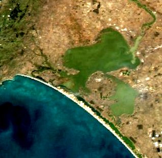
Coorong National Park is a protected area located in South Australia about 156 kilometres (97 mi) south-east of Adelaide, that predominantly covers a coastal lagoon ecosystem officially known as The Coorong and the Younghusband Peninsula on the Coorong's southern side. The western end of the Coorong lagoon is at the Murray Mouth near Hindmarsh Island and the Sir Richard Peninsula, and it extends about 130 kilometres (81 mi) south-eastwards. Road access is from Meningie. The beach on the coastal side of the peninsula, the longest in Australia, is also commonly called The Coorong.

D'Entrecasteaux National Park is a national park in Western Australia, 315 kilometres (196 mi) south of Perth. The park is named after the French Admiral Bruni D'Entrecasteaux who was the first European to sight the area and name Point D'Entrecasteaux in 1792. The park received 168,497 visitors through 2008–2009.

Lake Alexandrina is a coastal freshwater lake located between the Fleurieu and Kangaroo Island and Murray and Mallee regions of South Australia, about 100 kilometres (62 mi) south-east of Adelaide. The lake adjoins the smaller Lake Albert and a coastal lagoon called The Coorong to its southeast, before draining into the Great Australian Bight via a short, narrow opening known as Murray Mouth.

The Nepean River, is a major perennial river, located in the south-west and west of Sydney, New South Wales, Australia. The Nepean River, and, continuing by its downstream name, the Hawkesbury River, almost encircles the metropolitan region of Sydney.

Southwest Australia is a biogeographic region in Western Australia. It includes the Mediterranean-climate area of southwestern Australia, which is home to a diverse and distinctive flora and fauna.
Lake Corangamite, a hypersaline endorheic lake, is located near Colac in the Lakes and Craters region of the Victorian Volcanic Plains of south-west Victoria, Australia. The lake's salinity levels have increased dramatically as the lake level has dropped in recent decades. It is Australia's largest permanent saline lake, covering approximately 230 square kilometres (89 sq mi) with a circumference of 150 kilometres (93 mi). It forms part of the Ramsar-listed Western District Lakes wetland site. The Aboriginal name of the lake is recorded as Kronimite.

Pemberton is a town in the South West region of Western Australia, named after original settler Pemberton Walcott.

Whadjuk, alternatively Witjari, are Noongar people of the Western Australian region of the Perth bioregion of the Swan Coastal Plain.

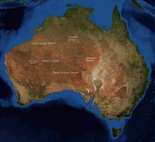
The deserts of Australia or the Australian deserts cover about 2,700,000 km2 (1,000,000 sq mi), or 18% of the Australian mainland, but about 35% of the Australian continent receives so little rain, it is practically desert. Collectively known as the Great Australian desert, they are primarily distributed throughout the Western Plateau and interior lowlands of the country, covering areas from South West Queensland, Far West region of New South Wales, Sunraysia in Victoria and Spencer Gulf in South Australia to the Barkly Tableland in Northern Territory and the Kimberley region in Western Australia.
Aboriginal Australians have inhabited Western Australia from around 50,000–70,000 years ago to present.

The Carbunup River is located in the south-west corner of Western Australia. The mouth of the Carbunup River is approximately 20 kilometres (12 mi) west of Busselton where the river flows into Geographe Bay.

}} Loch McNess, also known as Yanchep Lake, is a freshwater lake located near Yanchep in the northern part of the coastal plain of Perth, Western Australia. Loch McNess is part of the Wanneroo wetlands, a chain of lakes, and is part of the Yanchep National Park. Water from the lake is used to refill the underground lakes in some nearby caves.
The Goodga River is a river in the Great Southern region of Western Australia.

The Vasse-Wonnerup Estuary is an estuary in the South West region of Western Australia close to the town of Busselton. The estuary is listed with DIWA. It was also recognised as a wetland of international importance under the Ramsar Convention on 7 June 1990 when an area of 1,115 ha was designated Ramsar Site 484 as an important dry-season habitat for waterbirds. It is also the main part of the 2,038 ha (5,040-acre) Busselton Wetlands Important Bird Area.

Clarrie Hall Dam is a minor ungated concrete faced rockfill embankment dam with an uncontrolled concrete-lined chute spillway across the Doon Doon Creek, located upstream of the small town of Uki, in the Northern Rivers region of New South Wales, Australia. The main purpose of the dam is for water supply and it creates the artificial Lake Clarrie Hall.
The Buayanyup River is a river in the South West region of Western Australia.

Aboriginal Victorians, the Aboriginal Australians of Victoria, Australia, occupied the land for tens of thousands of years prior to European settlement. Aboriginal people have lived a semi-nomadic existence of fishing, hunting and gathering and associated activities for at least 40,000 years.
The Garrwa people, also spelt Karawa and Garawa, are an Aboriginal Australian people living in the Northern Territory, whose traditional lands extended from east of the McArthur River at Borroloola to Doomadgee and the Nicholson River in Queensland.

Lake Richmond is a freshwater lake in Rockingham, Western Australia. It is approximately 1,000 m × 600 m, with an area of 40 ha, and is 15 m (49 ft) deep in the centre. It is believed to be named after the London borough. It is part of Rockingham Lakes Regional Park.
Charles Eugene Dortch is a US born archaeologist, largely known for his life and works in Western Australia.


