
Western Finland was a province of Finland from 1997 to 2009. It bordered the provinces of Oulu, Eastern Finland and Southern Finland. It also bordered the Gulf of Bothnia towards Åland. Tampere was the largest city of the province.
Äänekoski is a town in Finland. It is located in the Central Finland region, about 45 kilometres (28 mi) north of Jyväskylä. The town has a population of 17,971 and covers an area of 1,138.39 square kilometres (439.53 sq mi) of which 253.84 km2 (98.01 sq mi) is water. The population density is 20.32 inhabitants per square kilometre (52.6/sq mi).
The 23 municipalities of the Central Finland Region in Finland are divided on six sub-regions.

Hankasalmi is a municipality of Finland.

Joroinen is a municipality in the North Savo region of Finland. It is located in the province of Eastern Finland and is part of the Northern Savonia sub-region. The municipality has a population of approximately 4,626 people and covers an area of 982 square kilometers.

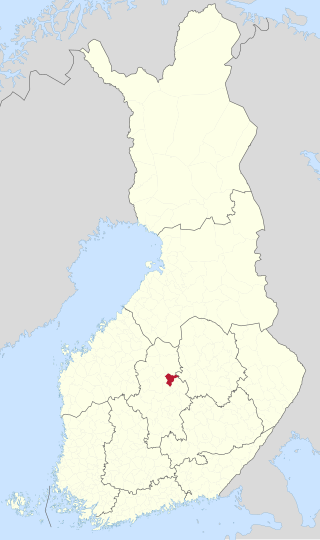
Konnevesi is a municipality of Finland. It is located in the former province of Western Finland and is part of the Central Finland region. The municipality has a population of 2,499 and covers an area of 680.85 square kilometres (262.88 sq mi) of which 167.95 km2 (64.85 sq mi) is water. Neighbouring municipalities are Hankasalmi, Laukaa, Rautalampi, Vesanto and Äänekoski. The municipality is unilingually Finnish.

Laukaa is a municipality of Finland. It is located next to Jyväskylä and is part of the Central Finland region. The municipality has a population of 18,762 and covers an area of 825.59 square kilometres (318.76 sq mi) of which 177.09 km2 (68.37 sq mi) is water. The population density is 28.93 inhabitants per square kilometre (74.9/sq mi).
Central Finland is a region in Finland. It borders the regions of Päijät-Häme, Pirkanmaa, South Ostrobothnia, Central Ostrobothnia, North Ostrobothnia, North Savo, and South Savo. The city of Jyväskylä is the regional centre and by far the largest city in the area. The Central Finland lies slightly south of the geographical centre of Finland. The landscape is hilly and a large part of the province belongs to the Finnish Lakeland.

Rautalampi is a municipality of Finland. It is located in the Northern Savonia region. The municipality has a population of 2,933 and covers an area of 761.98 square kilometres (294.20 sq mi) of which 222.99 km2 (86.10 sq mi) is water. The population density is 5.44 inhabitants per square kilometre (14.1/sq mi). The municipality is unilingually Finnish.
Vesanto is a municipality of Finland. It is located in the Northern Savonia region. The municipality has a population of 1,895 and covers an area of 569.80 square kilometres (220.00 sq mi) of which 147.1 km2 (56.8 sq mi) is water. The population density is 4.48 inhabitants per square kilometre (11.6/sq mi).

The Savonian dialects are forms of the Finnish language spoken in Savonia and other parts of Eastern Finland. Finnish dialects are grouped broadly into Eastern and Western varieties; Savonian dialects are of the Eastern variety.
The Central Finland Province was a province of Finland from 1960 to 1997. The area of the Central Finland Province was the same as the area of Central Finland region.

Kiesimä is a medium-sized lake of Finland. It belongs in the Kymijoki main catchment area. It is located in the region Pohjois-Savo. The Kiesimä Canal connects the lake westwards to the lake Konnevesi and the Kerkonkoski Canal connects it eastwards to the lake Niinivesi.
Liesvesi is a medium-sized lake of Central Finland in the Kymijoki main catchment area. It is situated in the Konnevesi municipality. It belongs to the Konnevesi-Laukaa canoeing route.

Kynsivesi–Leivonvesi is a medium-sized lake of Central Finland, in the municipalities of Laukaa, Hankasalmi and Konnevesi. It belongs to the Kymijoki main catchment area. The outflow to the lake Kuusvesi is Simunankoski rapids.
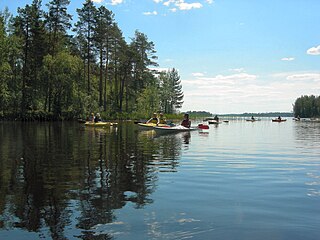
Southern Konnevesi National Park is situated in the Finnish Lakeland on the border of the regions Central Finland and Northern Savonia, in the municipalities of Konnevesi and Rautalampi.

The Finnish national road 69 is the 2nd class main route from Äänekoski's Hirvaskangas to Suonenjoki's Levä. The length of the road is 88 kilometers. The road as a whole is two-lane and of varying quality.
Konginkangas is a settlement and former municipality of Finland in the Central Finland region. It was consolidated with Äänekoski in 1993.

Äänekosken maalaiskunta is a former municipality of Finland in the Central Finland region. It was consolidated with the kauppala of Äänekoski in 1969.

