Lake Lafayette

Last updated
Lake Lafayette
USA Florida relief location map.jpg
Red pog.svg
Lake Lafayette
Usa edcp relief location map.png
Red pog.svg
Lake Lafayette
Lake Lafayette TLH.gif
Map of Upper Lake Lafayette, Lake Lafayette, Piney Z Lake and Alford Arm
Location Tallahassee, Leon County, Florida
Coordinates 30°26′15″N84°10′25″W / 30.4376°N 84.1736°W / 30.4376; -84.1736
Type prairie lake, hypereutrophic
Catchment area 79.6 sq mi (206 km2)
Basin  countriesUnited States
Surface area2.85 sq mi (7.4 km2)

Lake Lafayette is a prairie lake located in the coastal lowland in eastern Tallahassee, Leon County, Florida with US 27 / State Road 20 running close on its south side.

Contents

History

Prehistoric

Originally known as Prairie Lake, Lake Lafayette is the remnant of a Pleistocene river delta. [1] Water levels receded in the last ice age and the coast moved farther south of the site which became a river valley and eventual a tributary of the St. Marks River. Dissolution processes culminated in the formation of a large basin, 8,925 acres (36.12 km2), a major sinkhole is located in Upper Lake Lafayette just South of the Cody Scarp.

The Lake Lafayette Basin is considered to be one of the premier paleoarchaelological sites in Florida. [1] The lake area is surrounded by archaeological sites. A large number of Native American mounds surround the lake; one excavated mound is currently displayed at the Florida Museum of Natural History. The large middens on Lake Piney Z, and the Temple Mounds at Fallschase, are of particular interest. Native American settlements are common in the Lafayette Basin and Hernando de Soto spent the first Christmas in the New World at one of these sites.

Early 1800s

The early settlers of Leon County called Lake Lafayette 'Prairie Lake' as it looked much like a prairie during droughts. The lake took its name from the Lafayette land grant, the township (36-square-mile tract) on the north and east side of Tallahassee that was granted by the US Congress in 1824 to General Lafayette in gratitude for his military services in the American Revolutionary War.

In the late 1820s, portions of the Lafayette grant around the lake were sold and became plantations, each a few thousand acres in size. The Francis Eppes Plantation, Evergreen Hills Plantation and the Joseph Chaires Plantation grew cotton until the 1860s.

20th Century

Lake Piney Z Lake Piney Z.jpg
Lake Piney Z

Lake Lafayette functioned as one hydrological unit until 1948, when the owners of Piney Z Plantation constructed two earthen dikes in the middle of the lake and turned the central part of Lake Lafayette into a farm pond. [1] More dikes were constructed and the lake was further broken up creating Upper Lake Lafayette, Piney Z Lake, Lower Lake Lafayette, and the Alford Arm. [1] This began the process which started the lake(s) to transform into a vegetated marsh.

Of the four major lake basins in Leon County - Lake Jackson, Lake Iamonia, Lake Miccosukee, and Lake Lafayette - the Lake Lafayette basin is the most intensively developed; [1] it is also considered the most modified lake basin in all of northern Florida, since it is no longer functioning in a natural fashion due to human effects. [1] Lafayette Basin once functioned as a temporary lake, much like Lake Miccosukee and Lake Iamonia where water was frequently exchanged between the Lake Basin, the Floridan Aquifer (sink holes) and the St. Marks River through a series of connecting sloughs.

Lower Lake Lafayette is covered with floating islands of aquatic vegetation, called tussocks, usually the root systems of decaying Fragrant Water Lily, an invasive species. These are colonized by aquatic grasses, sedges and even small trees which float around the lake driven by the winds. They can trap or crush boats, docks and piers.

Geography

Lafayette Creek watershed Lafayette Creek watershed.png
Lafayette Creek watershed

Lake Lafayette is fed by Lafayette Creek, draining a significant portion of northeastern Tallahassee; it has a drainage basin of approximately 10 sq mi (26 km2). [2] The creek flows into a small reservoir upstream from Lake Lafayette, impounded by a weir at the Weems Road bridge, then continues into Upper Lake Lafayette. Lower Lake Lafayette formerly flowed into the St. Marks River underground, and in sheet flow after heavy rains; it currently is connected to the river by a canal. [1]

Scientific

  1. Lake Lafayette has a surface area of 2.85 square miles (7.4 km2) and a drainage basin of 79.6 square miles (206 km2) and is classified as Hypereutrophic.
  2. Upper Lake Lafayette has a surface area of 0.46 square miles (1.2 km2) and a drainage basin of 23.4 square miles (61 km2). It's classified as hypereutrophic.
  3. Lake Piney Z has a surface area of 0.3 square miles (0.78 km2) and a drainage basin of 1.5 square miles (3.9 km2) It's classified as hypereutrophic.
  4. Lower Lake Lafayette (including Alford Arm) has a surface area of 2 square miles (5.2 km2) and a drainage basin of 54.6 square miles (141 km2) and classified as hypereutrophic.

Recreation

Lake Lafayette offers several opportunities for recreation. Lafayette Heritage Trail Park is a public recreational park located in Tallahassee, Florida. The park offers many activities such as picnicking, hiking, fishing, kayaking, and mountain biking. The central feature of the park is Lake Piney Z, a 200-acre lake that is part of the Lake Lafayette system. "Two dams constructed around 1950 divided the lake into three sections, Upper Lafayette continues to be a wet prairie, Piney Z Lake is a 200 acre open water lake, and Lower Lafayette resembles a cypress-covered Louisiana bayou." The park has limited access to Lower Lake Lafayette, and is adjacent to Piney Z Plantation neighborhood as well as Tom Brown Park. The park is open sunrise to sunset. [3]

Fishing is a popular activity in Lake Lafayette. Most of the fishing opportunities are in Piney Z and Lower Lake Lafayette with the former being the most popular. Visitors have access to Lake Piney Z via 7 fishing fingers as well as a hand launch boat ramp. The boat ramp offers access for kayaks and small boats; however, the lake is electric motor only and all watercraft must be carried to the water by hand as there is no trailer access. Many local residents frequent the parks numerous fishing fingers in pursuit of the two most popular species at lake Piney Z; largemouth bass and bream. Thanks to efforts by the FWC, the park hosts a healthy population of fish. FWC officials have placed several vegetation patches and fish attractors throughout the lake in order to improve catch rates for fishermen and improve the habitat of the fishery. The lake hosts a very large population of largemouth bass with bass averaging on the small side in the 9"-12" range with the occasional bass surpassing three pounds. Bass fishing can often be fast and furious from shore when a school of feeding bass swims within casting distance. It was originally prohibited to harvest largemouth bass from Piney Z; however, harvesting regulations have since been changed to align with the current FWC regulations for Florida lakes. Bluegill populations diminished over the years when largemouth bass harvest was prohibited. Numbers are expected to rebound with the repeal of the largemouth bass ban and the annual fall stocking of bluegill in Piney Z. [4]

Lafayette heritage trail park

Lafayette Heritage Trail Park is a public recreational park located in Tallahassee, Florida. The park offers many activities such as picnicking, hiking, fishing, kayaking, and mountain biking. The central feature of the park is Lake Piney Z, a 200-acre lake that is part of the Lake Lafayette system. "Two dams constructed around 1950 divided the lake into three sections, Upper Lafayette continues to be a wet prairie, Piney Z Lake is a 200 acre open water lake, and Lower Lafayette resembles a cypress-covered Louisiana bayou." The park is adjacent to Piney Z Plantation neighborhood and Tom Brown Park. The park is open sunrise to sunset. [3]

Trails

Lafayette Heritage Trail Park has several trails that offer hiking, running, and cycling opportunities. A map of the trail system can be found here.

In addition to the various footpath trails and mountain biking trails, Lafayette Heritage Trail park also serves as the start of the Lafayette Passage paddling trail. [5]

Fishing

Lafayette Heritage Trail Park offers some of the best bank fishing in the Tallahassee area. Visitors have access to Lake Piney Z via 7 fishing fingers as well as a hand launch boat ramp. The boat ramp offers access for kayaks and small boats; however, the lake is electric motor only and all watercraft must be carried to the water by hand as there is no trailer access. Many local residents frequent the parks numerous fishing fingers in pursuit of the two most popular species at lake Piney Z; largemouth bass and bream. Thanks to efforts by the FWC, the park hosts a healthy population of fish. FWC officials have placed several vegetation patches and fish attractors throughout the lake in order to improve catch rates for fishermen and improve the habitat of the fishery. The lake hosts a very large population of largemouth bass with bass averaging on the small side in the 9"-12" range with the occasional bass surpassing three pounds. Bass fishing can often be fast and furious from shore when a school of feeding bass swims within casting distance. It was originally prohibited to harvest largemouth bass from Piney Z; however, harvesting regulations have since been changed to align with the current FWC regulations for Florida lakes. Bluegill populations diminished over the years when largemouth bass harvest was prohibited. Numbers are expected to rebound with the repeal of the largemouth bass ban and the annual fall stocking of bluegill in Piney Z. [4]

Other species of fish that inhabit the lake include bowfin, gar, and crappie.

Related Research Articles

<span class="mw-page-title-main">Pettigrew State Park</span> State park in North Carolina, United States

Pettigrew State Park is a North Carolina State Park in Tyrrell and Washington Counties, North Carolina in the United States. It covers 5,951 acres (24.08 km2) around the shore lines of Lake Phelps and the Scuppernong River. The park's developed facilities are south of U.S. Route 64 near Roper and Creswell, North Carolina. Pettigrew State Park is open for year-round recreation, including hiking, camping, fishing, boating and picnicking.

<span class="mw-page-title-main">Paynes Prairie Preserve State Park</span> Protected ecological system in Florida

Paynes Prairie Preserve State Park is a Florida State Park, encompassing a 21,000-acre (85 km2) savanna in Alachua County, Florida lying between Micanopy and Gainesville. It is also a U.S. National Natural Landmark. It is crossed by both I-75 and U.S. 441. It is in the center of the Paynes Prairie Basin. The basin's primary source of drainage is Alachua Sink. During occasional wet periods, the basin will become full. A notable period occurred from 1871 to 1891 when the Alachua Sink was temporarily blocked. During this period, shallow draft steamboats were a frequent sight on Alachua Lake in the center of the prairie. The region was also historically known as the Alachua Savannah. Its drainage has been modified by several canals. Since 1927, Camps Canal has linked the basin to the River Styx which leads to Orange Lake and eventually the Atlantic Ocean through the St. Johns River. That reduced the basins water intake by half. Additional changes to the prairie's environment have been detrimental to its hydrology. In 1970, the state of Florida acquired the land and has been in the process of restoring the environment to a more natural condition ever since.

<span class="mw-page-title-main">Lake Murray (California)</span> Reservoir in San Diego, California

Lake Murray is a reservoir in San Diego, California, operated by the City of San Diego's Public Utilities Department. Although thinly divided by a few housing communities and select roadways, it is technically considered to be part of the jurisdiction which makes up Mission Trails Regional Park. When full, the reservoir covers 171.1 acres (69.2 ha), has a maximum water depth of 95 feet (29 m), and a shoreline of 3.2 miles (5.1 km). The asphalt-paved service road lining roughly two-thirds of the lake's perimeter is a popular recreation site for the Navajo community as well as residents of the northernmost neighborhoods in La Mesa. It lies south of Cowles Mountain and a small golf course. It also functions as an important aeronautical reporting point for aircraft inbound to land at Montgomery-Gibbs Executive Airport.

<span class="mw-page-title-main">Oscar Scherer State Park</span> State park in Florida, United States

Oscar Scherer State Park is a Florida State Park located between Sarasota and Venice, near Osprey. The address is 1843 South Tamiami Trail. There are more than 250,000 visitors a year.

<span class="mw-page-title-main">Lake Iamonia</span> Lake in the state of Florida, United States

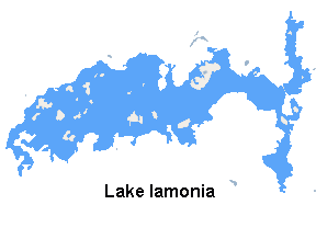
Lake Iamonia⟨aɪ ˈmoʊ njə⟩ is a large, subtropical prairie lake in northern Leon County, Florida, United States, created during the Pleistocene epoch.

<span class="mw-page-title-main">Sardis Lake (Mississippi)</span> Reservoir in Mississippi, US

Sardis Lake is a 98,520-acre (398.7 km2) reservoir on the Tallahatchie River in Lafayette, Panola, and Marshall counties, Mississippi. Sardis Lake is impounded by Sardis Dam, located nine miles (14 km) southeast of the town of Sardis. It is approximately an hour drive from Memphis, Tennessee. The dam is 15,300 feet (4,700 m) long, has an average height of 97 feet (30 m), and a maximum height of 117 feet (36 m).

<span class="mw-page-title-main">Banks Lake National Wildlife Refuge</span>

The Banks Lake National Wildlife Refuge is a 4,049 acre (16.4 km²) National Wildlife Refuge located in Lanier County, Georgia. Banks Lake is a natural pocosin or sink of ancient geologic origin. The refuge was established in 1985 for the protection and conservation of this unique environment as well as migratory and resident wildlife.

<span class="mw-page-title-main">Kettle Creek State Park</span> State park in Pennsylvania, United States

Kettle Creek State Park is a 1,793-acre (726 ha) Pennsylvania state park in Leidy Township, Clinton County, Pennsylvania in the United States. The park is in a valley and is surrounded by mountains and wilderness. It features the Alvin R. Bush Dam built in 1961 by the U.S. Army Corps of Engineers as a flood control measure in the West Branch Susquehanna River basin. Many of the recreational facilities at the park were built during the Great Depression by the young men of the Civilian Conservation Corps. Kettle Creek State Park is seven miles (10 km) north of Westport and Pennsylvania Route 120. It is largely surrounded by Sproul State Forest.

<span class="mw-page-title-main">Sinnemahoning State Park</span> State park in Cameron and Potter counties, Pennsylvania

Sinnemahoning State Park is a 1,910-acre (773 ha) Pennsylvania state park in Grove Township, Cameron County and Wharton Township, Potter County, Pennsylvania, in the United States. The park is surrounded by Elk State Forest and is mountainous with deep valleys. The park is home to the rarely seen elk and bald eagle. Sinnemahoning State Park is on Pennsylvania Route 872, eight miles (13 km) north of the village of Sinnamahoning. In 1958, the park opened under the direction of the Pennsylvania Bureau of Forestry: it became a Pennsylvania State Park in 1962.

<span class="mw-page-title-main">Yellowstone Lake State Park</span> State Park in Lafayette County, Wisconsin

Yellowstone Lake State Park is a state park of Wisconsin, United States, featuring a 455-acre (184 ha) reservoir on a tributary of the Pecatonica River. The state park is included in the 4,047-acre (1,638 ha) Yellowstone Lake State Wildlife Area. The park has 128 campsites and 5 group sites. There is a swimming area with sand beach, picnic areas, and playgrounds. Boat launch, boat rentals, fishing for bluegill, largemouth bass, walleye and channel catfish, with some northern pike and muskellunge. Hiking trails, and groomed cross country ski trails. The adjacent 4,000 acre wildlife area offers extensive horse trails and a shooting range.

<span class="mw-page-title-main">Lake Overstreet</span> Lake in the state of Florida, United States

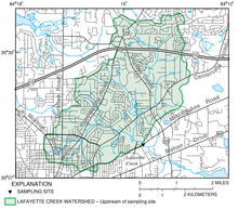
Lake Overstreet is a lake in Leon County, Florida, United States. It is 144 acres (0.58 km2) in size and falls within the property of Alfred B. Maclay Gardens State Park and is just northwest of Lake Hall by 500 feet (150 m). Access to the lake is only by hiking and mountain bike trails.

<span class="mw-page-title-main">Chicot State Park</span> State park in Louisiana, United States

Chicot State Park is located near Ville Platte, Louisiana. This wildlife reserve of South Central Louisiana features 6,400 acres (26 km2) of rolling hills surrounding a 2,000-acre (8 km2) man-made lake stocked with bass, crappie (sac-au-lait), bluegill, and red-ear sunfish. Chicot Park offers fishing boat rentals, pavilions, barbecue pits, picnic areas, restrooms, primitive hike-to campsites, lodges, and furnished cabins. The park is home to a number of wild animal species, including whitetail deer, raccoons, coyotes, and bobcats.

<span class="mw-page-title-main">Howard Prairie Lake</span> Reservoir in Southern Oregon, United States

Howard Prairie Lake is a reservoir located 4,526 feet (1,380 m) above sea level in Jackson County, Oregon, United States. It is 18 miles (29 km) east of Ashland. The lake is formed by the 100-foot (30 m) tall Howard Prairie Dam, which impounds Beaver Creek, in the Klamath River watershed.

Kirby Lake is a 740-acre man-made reservoir located on the south side of Abilene, Texas, just east of Highway 83, in the northeastern portion of Taylor County. Kirby Lake is within the Brazos River Basin, meaning that Cedar Creek, which feeds Kirby Lake, eventually feeds into the Brazos River. Kirby Lake resides in the Red Prairies portion of the Central Great Plains ecoregion. Management is under the City of Abilene.

<span class="mw-page-title-main">Tenmile Lake (Oregon)</span>

Tenmile Lake is the largest and southernmost of a chain of lakes along the Oregon Coast south of the Umpqua River in the United States. The chain includes North Tenmile, Eel, Clear, and smaller lakes, which drain into the Pacific Ocean via Tenmile Creek. The lake is 8 miles (13 km) south of Reedsport and 0.5 miles (0.80 km) east of U.S. Route 101 near the community of Lakeside.

Lake Elizabeth is a tiny natural freshwater lake in Winter Haven, Florida. This lake is round and has a 0.91-acre (3,700 m2) surface area. This lake is bordered on all but the south side by residences along Lake Elizabeth Drive. A normally dry drainage basin, which is much larger than Lake Elizabeth, is on the south side. This lake has many large trees in the properties around it and much of it is always shaded.

Highlandtown Lake is a man-made lake located in Washington Township, Columbiana County, Ohio. It was created in 1966 when the State of Ohio built a dam impounding 170 acres (0.69 km2) of water on the upper drainage of the Little Yellow Creek. A lot of habitat improvement was done on what would be the bottom of the lake prior to the impoundment. It has about 5 miles (8.0 km) of shoreline and a maximum depth of about 26 feet (7.9 m). The lake is about 1,100 feet (340 m) above sea level.

<span class="mw-page-title-main">Floras Lake</span> Lake in the U.S. state of Oregon

Floras Lake is a natural 236-acre (96 ha) body of water on the southern Oregon Coast of the United States. Fed by four small tributaries from a basin of about 10 square miles (26 km2) in Curry County, it lies about 10 miles (16 km) north of Port Orford and 2 miles (3 km) west of U.S. Route 101. It was probably named for Fred Flora, a 19th-century settler and miner who lived nearby.

<span class="mw-page-title-main">Nine Eagles State Park</span> State park in Decatur County, Iowa

Nine Eagles State Park is a 1,100-acre (450 ha) state park in Decatur County, Iowa, United States, near the city of Davis City. The park is located within a hilly area of the state and includes a 64-acre (26 ha) lake.

<span class="mw-page-title-main">Lake Leon (Texas)</span> Lake in Texas

Lake Leon is located in Eastland County and was created by the State Board of Water Engineers by impounding the Leon River. In reference to Abilene, Texas with a population of around 125,000, it is 68 miles east, and in reference to Eastland, Texas with a population of around 4,000, it is 10 miles southeast. Lake Leon is found in the Brazos River and in the Cross Timbers ecoregion, more specifically the Cross Timbers Grand Prairie ecoregion.

References

Citations
  1. 1 2 3 4 5 6 7 McGlynn, Sean. "Lake Lafayette". TAPP. City of Tallahassee. Archived from the original on 2013-04-15. Retrieved 2012-09-12.
  2. Berndt and Hatzell 2001, p.2.
  3. 1 2 "Lafayette Heritage Trail Park". Talgov. Retrieved 4 June 2017.
  4. 1 2 "laffish.pdf" (PDF). Talgov. City of Tallahassee Government. Archived from the original (PDF) on 16 July 2014. Retrieved 4 June 2017.
  5. "Lafayette Passage Paddling Trail". www.talgov.com. Retrieved June 4, 2017.
Bibliography