Related Research Articles

The Continental Divide of the Americas is the principal, and largely mountainous, hydrological divide of the Americas. The Continental Divide extends from the Bering Strait to the Strait of Magellan, and separates the watersheds that drain into the Pacific Ocean from those river systems that drain into the Atlantic and Arctic Ocean, including those that drain into the Gulf of Mexico, the Caribbean Sea, and Hudson Bay.

Lake Agassiz was a large proglacial lake that existed in central North America during the late Pleistocene, fed by meltwater from the retreating Laurentide Ice Sheet at the end of the last glacial period. At its peak, the lake's area was larger than all of the modern Great Lakes combined. It eventually drained into what is now Hudson Bay, leaving behind Lake Winnipeg, Lake Winnipegosis, Lake Manitoba, and Lake of the Woods.

The Athabasca River is a river in Alberta, Canada, which originates at the Columbia Icefield in Jasper National Park and flows more than 1,231 km (765 mi) before emptying into Lake Athabasca. Much of the land along its banks is protected in national and provincial parks, and the river is designated a Canadian Heritage River for its historical and cultural importance. The scenic Athabasca Falls is located about 30 km (19 mi) upstream from Jasper.

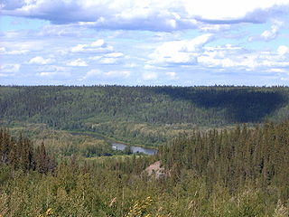
The Mackenzie River is a river in the Canadian boreal forest. It forms, along with the Slave, Peace, and Finlay, the longest river system in Canada, and includes the second largest drainage basin of any North American river after the Mississippi.

Lake Athabasca is in the north-west corner of Saskatchewan and the north-east corner of Alberta between 58° and 60° N in Canada. The lake is 26% in Alberta and 74% in Saskatchewan.

The Interior Plains is a vast physiographic region that spreads across the Laurentian craton of central North America, extending along the east flank of the Rocky Mountains from the Gulf Coast region to the Arctic Beaufort Sea. In Canada, it encompasses the Canadian Prairies separating the Canadian Rockies from the Canadian Shield, as well as the Boreal Plains and Taiga Plains east of the Mackenzie and Richardson Mountains; while in the United States, it includes the Great Plains of the West/Midwest and the tallgrass prairie region to the south of the Great Lakes extending east to the Appalachian Plateau region.

Great Slave Lake is the second-largest lake in the Northwest Territories of Canada, the deepest lake in North America at 614 m (2,014 ft), and the tenth-largest lake in the world by area. It is 469 km (291 mi) long and 20 to 203 km wide. It covers an area of 27,200 km2 (10,500 sq mi) in the southern part of the territory. Its given volume ranges from 1,070 km3 (260 cu mi) to 1,580 km3 (380 cu mi) and up to 2,088 km3 (501 cu mi) making it the 10th or 12th largest by volume.
Peter Pond was an American explorer, cartographer, merchant and soldier who was a founding member of the North West Company and the Beaver Club. Though he was born and died in Milford, Connecticut, most of his life was spent in northwestern North America, on the upper Mississippi and in western Canada.

The Slave River is a Canadian river that flows from the confluence of the Rivière des Rochers and Peace River in northeastern Alberta and runs into Great Slave Lake in the Northwest Territories. The river's name is thought to derive from the name for the Slavey group of the Dene First Nations, Deh Gah Gotʼine, in the Athabaskan languages. The Chipewyan had displaced other native people from this region.

The Laurentide ice sheet was a massive sheet of ice that covered millions of square miles, including most of Canada and a large portion of the Northern United States, multiple times during the Quaternary glacial epochs, from 2.58 million years ago to the present.
The Clearwater River is located in the Canadian provinces of Saskatchewan and Alberta. It rises in the northern forest region of north-western Saskatchewan and joins the Athabasca River in north-eastern Alberta. It was part of an important trade route during the fur trade era and has been designated as a Canadian Heritage River.

Lake Claire is the largest lake which is entirely in Alberta, Canada. It is located entirely in Wood Buffalo National Park, west of Lake Athabasca. It lies between the mouths of Peace River and Athabasca River, and is part of the Peace-Athabasca Delta system.

Northern Alberta is a geographic region located in the Canadian province of Alberta.
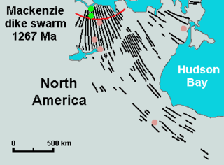
The Mackenzie dike swarm, also called the Mackenzie dikes, forms a large igneous province in the western Canadian Shield of Canada. It is part of the larger Mackenzie Large Igneous Province and is one of more than three dozen dike swarms in various parts of the Canadian Shield.

The Mackenzie River in Canada's Northwest Territories is a historic waterway, used for centuries by Indigenous peoples, specifically the Dene, as a travel and hunting corridor. Also known as the Deh Cho, it is part of a larger watershed that includes the Slave, Athabasca, and Peace rivers extending from northern Alberta. In the 1780s, Peter Pond, a trader with the North West Company became the first known European to visit this watershed and begin viable trade with the Athapascan-speaking Dene of these rivers. The Mackenzie River itself, the great waterway extending to the Arctic Ocean, was first put on European maps by Alexander Mackenzie in 1789, the Scottish trader who explored the river. The watershed thus became a vital part of the North American fur trade, and before the advent of the airplane or road networks, the river was the only communication link between northern trading posts and the south. Water travel increased in the late 19th century as traders, dominated primarily by the Hudson's Bay Company (HBC), looked to increase water services in the Mackenzie River District.

Marine Transportation Services (MTS) formerly Northern Transportation Company Limited (NTCL) is a marine transportation company operating primarily in the Mackenzie River watershed of the Northwest Territories and northern Alberta, and the Arctic Ocean using a fleet of diesel tug boats and shallow-draft barges. NTCL filed for bankruptcy in 2016 and its assets were acquired by the Government of the Northwest Territories later that year.
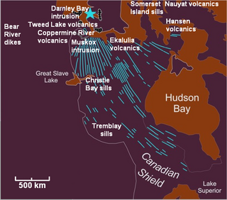
The Mackenzie Large Igneous Province (MLIP) is a major Mesoproterozoic large igneous province of the southwestern, western and northwestern Canadian Shield in Canada. It consists of a group of related igneous rocks that were formed during a massive igneous event starting about 1,270 million years ago. The large igneous province extends from the Arctic in Nunavut to near the Great Lakes in Northwestern Ontario where it meets with the smaller Matachewan dike swarm. Included in the Mackenzie Large Igneous Province are the large Muskox layered intrusion, the Coppermine River flood basalt sequence and the massive northwesterly trending Mackenzie dike swarm.
The phenomenon of paleoflooding is apparent in the geologic record over various spatial and temporal scales. It often occurred on a large scale, and was the result of either glacial ice melt causing large outbursts of freshwater, or high sea levels breaching bodies of freshwater. If a freshwater outflow event was large enough that the water reached the ocean system, it caused changes in salinity that potentially affected ocean circulation and global climate. Freshwater flows could also accumulate to form continental glacial lakes, and this is another indicator of large-scale flooding. In contrast, periods of high global sea level could cause marine water to breach natural dams and flow into bodies of freshwater. Changes in salinity of freshwater and marine bodies can be detected from the analysis of organisms that inhabited those bodies at a given time, as certain organisms are more suited to live in either fresh or saline conditions.
References
- 1 2 Smith, Derald G. (1994). "Glacial lake McConnell: Paleogeography, age, duration, and associated river deltas, mackenzie river basin, western Canada". Quaternary Science Reviews. 13 (9–10): 829–843. Bibcode:1994QSRv...13..829S. doi:10.1016/0277-3791(94)90004-3.
- 1 2 3 4 Pielou, E. C. (1992). After the Ice Age: The Return of Life to Glaciated North America. University of Chicago Press. p. 193. ISBN 0226668126 . Retrieved September 23, 2012.
- ↑ Bednarski, J. M. "Quaternary geology of northeastern Alberta". National Resources Canada. Retrieved September 23, 2012.
- ↑ Kerr, D. E.; Wilson, P. (2000). "Preliminary surficial geology studies and mineral exploration considerations in the Yellowknife area, Northwest Territories" (PDF). Geological Survey of Canada . Retrieved September 23, 2012.
- ↑ Padbury, G. A.; Acton, D. F.; Sturshnoff, Colette T. (1998). Ecoregions of Saskatchewan. CPRC Press. p. 54. ISBN 0889770972 . Retrieved September 23, 2012.