
Cape Le Grand National Park is a national park in Western Australia, 631 km (392 mi) south-east of Perth and 56 km (35 mi) east of Esperance. The park covers an area of 31,801 hectares The area is an ancient landscape which has been above sea level for well over 200 million years and remained unglaciated. As a result, the area is home to many primitive relict species. Established in 1966, the park is managed by the Department of Parks and Wildlife. The name Le Grand is from one of the officers on L'Espérance, one of the ships in the 1792 expedition of Bruni d'Entrecasteaux.

Peak Charles National Park is a national park in Western Australia, 507 kilometres (315 mi) east of Perth and 170 km (110 mi) north west of Esperance.

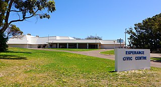
Esperance is a town in the Goldfields–Esperance region of Western Australia, on the Southern Ocean coastline approximately 720 kilometres (450 mi) east-southeast of the state capital, Perth and 189 kilometres (117 mi) south of Norseman. The urban population of Esperance was 12,145 at June 2018. Its major industries are tourism, agriculture, and fishing.

Coolgardie–Esperance Highway is a 370-kilometre (230 mi) Western Australian highway between Coolgardie and Esperance. It runs in a north–south direction linking the state's Eastern Goldfields to the coast.

Cocklebiddy is a small roadhouse community located on the Eyre Highway in Western Australia. It is the third stop after Norseman on the journey eastwards across the Nullarbor Plain. Like other locations in the region, the site consists of little more than a roadhouse. The current business name of the roadhouse is the Wedgetail Inn and, like most other Nullarbor establishments, has access to satellite television, as well as providing caravan park and hotel-motel facilities.
Lake Muir is a freshwater lake, with a larger surrounding wetlands area, that is located in the South West region of Western Australia. The lake lies near Muirs Highway, north of Walpole and southeast of Manjimup.

Mallee, also known as Roe Botanical District, is a biogeographic region in southern Western Australia. Located between the Esperance Plains, Avon Wheatbelt and Coolgardie bioregions, it has a low, gently undulating topography, a semi-arid mediterranean climate, and extensive Eucalyptus mallee vegetation. It has an area of 73,975.59 square kilometres (28,562.13 sq mi). About half of the region has been cleared for intensive agriculture. Recognised as a region under the Interim Biogeographic Regionalisation for Australia (IBRA), it was first defined by John Stanley Beard in 1980.
The Shire of Esperance is a local government area in the Goldfields-Esperance region of Western Australia, about 400 kilometres (250 mi) south of the town of Kalgoorlie and about 720 kilometres (450 mi) east-southeast of the state capital, Perth. The Shire covers an area of 42,547 square kilometres (16,427 sq mi), and its seat of government is the town of Esperance, where about three-quarters of the Shire's population resides.

Woody Island is an island off the south coast in the Goldfields-Esperance region of Western Australia.
The Archipelago of the Recherche, known locally as the Bay of Isles, is a group of 105 islands, and over 1200 "obstacles to shipping", off the south coast of Western Australia. The islands stretch 230 km (140 mi) from east to west and to 50 km (31 mi) off-shore encompassing an area of approximately 4,000 square kilometres (1,544 sq mi). The western group is near Esperance and the eastern group at Israelite Bay. They are located in coastal waters, part of which is designated the Recherche Archipelago Nature Reserve.

Quairading is a Western Australian town located in the Wheatbelt region. It is the seat of government for the Shire of Quairading.

Lake Hillier is a saline lake on the edge of Middle Island, the largest of the islands and islets that make up the Recherche Archipelago in the Goldfields-Esperance region, off the south coast of Western Australia. It is particularly notable for its pink colour. A long and thin shore divides the Southern Ocean from the lake.
Lake Warden is a salt lake in the Goldfields-Esperance region of Western Australia. It and its associated wetlands are protected in a nature reserve; they were recognised as being of international importance under the Ramsar Convention through designation of the Lake Warden System on 7 June 1990 as Ramsar Site 485. The lake is also a DIWA-listed wetland.

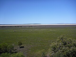
Pink Lake is a salt lake in the Goldfields-Esperance region of Western Australia. Although historically the water in the lake was visibly pink, as of 2017 it had not been pink for over ten years. Salt concentration is vital to Pink Lake's pink hue, and Pink Lake may turn pink again as conditions change. It lies about 3 kilometres (2 mi) west of Esperance and is bounded to the east by the South Coast Highway.
Lake Gore is a seasonal and semi-permanent saline lake in the Goldfields-Esperance region of Western Australia located approximately 24 km (15 mi) west of Esperance. It is an important site for waterbirds.
Lake Shaster is a hypersaline lake in the Goldfields-Esperance region of Western Australia, approximately 90 km (56 mi) west of Esperance.

Middle Island is an island off the south coast of Western Australia in the Recherche Archipelago, around 120 km (75 mi) south-east of Esperance. It is known for its pink lake, Lake Hillier. Goose Island lies just adjacent to the north.

The 2015 Esperance bushfires were a series of catastrophic bushfires that burned from 15 to 26 November and affected the Goldfields-Esperance region in the Australian state of Western Australia. During the fires, the Shire of Esperance experienced two significant fires and a complex of fires; 128,000 hectares were burnt by the Cascades fire, 18,000 hectares were burnt by the Merivale fire, and 164,000 hectares were burnt by the Cape Arid complex of fires. On 17 November, during the major run of the Cascades fire, four civilian fatalities occurred in vehicles traveling on Griggs Road in Scaddan. As of 2020, the Cascades fire was equally the worst bushfire in Western Australia in terms of human fatalities along with the Willow Springs/Nannup fire of January 1958.
Shark Lake is a freshwater lake in the Goldfields-Esperance region of Western Australia approximately 13 kilometres (8 mi) north of Esperance.
Woody Lake is a salt lake in the Goldfields-Esperance region of Western Australia, approximately 7 kilometres (4 mi) north east of Esperance. The lake is between Lake Wheatfield to the east and Windabout Lake to the west.


