
Seward Park is a neighborhood in southeastern Seattle, Washington, just west of Seward Park. It is part of Seattle's South End. The park occupies all of Bailey Peninsula.
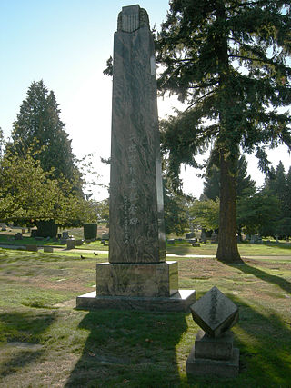
Lake View Cemetery is a private cemetery located in Seattle, Washington, in the Capitol Hill neighborhood, just north of Volunteer Park. Known as "Seattle's Pioneer Cemetery," it is run by an independent, non-profit association. It was founded in 1872 as the Seattle Masonic Cemetery and later renamed for its view of Lake Washington to the east.
Seward Park is a municipal park in Seattle, Washington, United States. Located in the city neighborhood of the same name, it covers 300 acres. The park occupies all of Bailey Peninsula, a forested peninsula that juts into Lake Washington. It contains one of the last surviving tracts of old-growth forest within the city of Seattle. The park is named after U.S. Secretary of State William Seward.

Queen Anne is a neighborhood in northwestern Seattle, Washington. Queen Anne covers an area of 7.3 square kilometers (2.8 sq mi), and has a population of about 28,000. It is bordered by Belltown to the south, Lake Union to the east, the Lake Washington Ship Canal to the north and Interbay to the west.

Leschi is a neighborhood in the city of Seattle, Washington, United States. Located on the western shore of Lake Washington, the residential neighborhood was named by its 19th-century developer for Chief Leschi of the Nisqually tribe, who was executed by territorial authorities in 1858 in Pierce County, Washington.
Magnuson Park is a park in the Sand Point neighborhood of Seattle, Washington, United States. At 350 acres (140 ha) it is the second-largest park in Seattle, after Discovery Park in Magnolia. Magnuson Park is located at the site of the former Naval Station Puget Sound, on the Sand Point peninsula with Pontiac and Wolf bays that juts into Lake Washington in northeast Seattle.

Washington Park is a public park in Seattle, Washington, United States, most of which is taken up by the Washington Park Arboretum, a joint project of the University of Washington, the Seattle Parks and Recreation, and the nonprofit Arboretum Foundation. Washington Park also includes a playfield and the Seattle Japanese Garden in its southwest corner. To the north is Union Bay; to the west are Montlake and Madison Valley; to the south is the Washington Park neighborhood; and to the east is the Broadmoor Golf Club.

Denny Blaine Park is a 2 acres (8,100 m2) water-front park in the Denny-Blaine neighborhood of Seattle, Washington. With picturesque views of Bellevue directly across the lake and Mount Rainier in the distance, it is primarily used for picnicking, sunbathing, and swimming. The park has also been one of Seattle's unofficial queer- and trans-friendly clothing optional beaches since the 1970s.

The Seattle Japanese Garden is a 3.5-acre (1.4 ha) Japanese garden in the Madison Park neighborhood of Seattle. The garden is located in the southern end of the Washington Park Arboretum on Lake Washington Boulevard East. The garden is one of the oldest Japanese gardens in North America, and is regarded as one of the most authentic Japanese gardens in the United States.

Lake City is a neighborhood and the northeast region of Seattle, centered along Lake City Way NE (SR-522), 7–8 miles (11–13 km) northeast of Downtown Seattle. A broader definition of the Lake City area includes all the land between 15th Avenue NE and Lake Washington, and between NE 95th and 98th streets to the Seattle city limits at NE 145th Street. Lake City encompasses much of the Thornton Creek watershed, the focus of a long restoration campaign by citizens and Seattle Public Utilities staff to enhance the residential environment of Lake City.

Mount Baker is a neighborhood in southeastern Seattle, Washington. The neighborhood's name comes from the view of Mount Baker in Whatcom County, that is seen by looking north over Lake Washington. It is bounded by Lake Washington to the east, Interstate 90 and then Leschi to the north, Rainier Valley to the west, and Columbia City to the south. The neighborhood has a community club and a rowing team. It hosts Seattle's annual Seafair, which includes an airshow featuring the U.S. Navy Blue Angels, hydroplane races, a fireworks show, and other festivities. Franklin High School and Garfield High School serve this area. It is part of Seattle's South End.
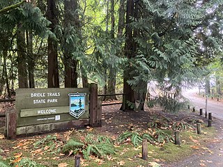
Bridle Trails State Park is a 489-acre (198 ha) state park in the Bridle Trails neighborhood in an unincorporated part of the Eastside area of King County, Washington. Established in 1932 and developed in 1933 by the Civil Works Administration, primary features of the park include a forested trail system shared by pedestrians and equestrians and an outdoor arena used for equestrian purposes.

Matthews Beach is a neighborhood in Seattle, Washington; it and Meadowbrook are the southern neighborhoods of the annexed township of Lake City (1954). Matthews Beach lies about 2 miles (3.2 km) northeast of the University of Washington, about 8 miles (13 km) northeast of Downtown.

Ravenna Park and Cowen Park comprise a single contiguous recreation and green space between the Ravenna and University District neighborhoods of Seattle, Washington in the United States. These public parks encompass the ravine with a maximum depth of 115 feet (35 m) through which Ravenna Creek flows.
Freeway Park, officially known as Jim Ellis Freeway Park, is an urban park in Seattle, Washington, United States, connecting the city's downtown to the Seattle Convention Center and First Hill. The park sits atop a section of Interstate 5 and a large city-owned parking lot; 8th Avenue also bridges over the park. An unusual mixture of brutalist architecture and greenery, the 5.2-acre (21,000 m2) park, designed by Lawrence Halprin's office under the supervision of Angela Danadjieva, opened to the public on July 4, 1976, at a cost of $23.5 million. An expansion of the park that stretches several blocks up First Hill, including a stairway and wheelchair ramp, was opened in 1982.

Rainier Beach is a set of neighborhoods in Seattle, Washington that are mostly residential. Also called Atlantic City, Rainier Beach can include Dunlap, Pritchard Island, and Rainier View neighborhoods.

Lake Union Park is a 12-acre (4.9 ha) park located at the south end of Lake Union in Seattle, Washington in the South Lake Union neighborhood. The park is owned by the City of Seattle and operated by Seattle Parks and Recreation. The park property was gradually acquired by the City, and the final 5 acres (2.0 ha) were transferred from the United States Navy to the City of Seattle on July 1, 2000. After renovation, the current park space officially opened on September 25, 2010.

Meadowbrook is a neighborhood in the Lake City district of Seattle, Washington. Meadowbrook is centered on open fields adjacent to the Community Center, Meadowbrook swimming pool, and Nathan Hale High School. It is bounded on the south by NE 95th Street and the Wedgwood neighborhood, on the north by NE 120th Street and Cedar Park, on the west by Lake City Way NE and Victory Heights, and on the east by 35th Avenue NE and Matthews Beach.
Pinehurst is a neighborhood in the Northgate area of Seattle, Washington, United States. It is bounded by NE 145th Street to the north, NE Northgate Way to the south, I-5 to the west, and Lake City Way to the east. These boundaries were determined by the Pinehurst Community Council. Pinehurst's northern boundary of NE 145th Street makes Pinehurst one of the northernmost neighborhoods in the city of Seattle.

Matthews Beach Park is a 22-acre (0.9 km2) park in the Matthews Beach neighborhood of Seattle, Washington. It is a popular swimming beach in the summer, although it is also open during winter months.

