Latvia lies on the eastern shores of the Baltic Sea on the level northwestern part of the rising East European platform, between Estonia and Lithuania. About 98% of the country lies under 200 m (656 ft) elevation. With the exception of the coastal plains, the ice age divided Latvia into three main regions: the morainic Western and Eastern uplands and the Middle lowlands. Latvia holds over 12,000 rivers, only 17 of which are longer than 100 km (60 mi), and over 3,000 small lakes, most of which are eutrophic. The major rivers include the Daugava, the Lielupe, the Gauja, the Venta and the Salaca. Woodlands cover around 52% of the country. Other than peat, dolomite, and limestone, natural resources are scarce. Latvia has 504 km (313 mi) of sandy coastline, and the ports of Liepāja and Ventspils provide important warm-water harbors for the Baltic coast.

Tallinn is the capital and most populous city of Estonia. Situated on a bay in north Estonia, on the shore of the Gulf of Finland of the Baltic Sea, Tallinn has a population of about 457,000 and administratively lies in the Harju maakond (county). Tallinn is the main governmental, financial, industrial, and cultural centre of Estonia. It is located 187 km (116 mi) northwest of the country's second largest city, Tartu; however, only 80 km (50 mi) south of Helsinki, Finland, also 320 km (200 mi) west of Saint Petersburg, Russia, 300 km (190 mi) north of Riga, Latvia, and 380 km (240 mi) east of Stockholm, Sweden. From the 13th century until the first half of the 20th century, Tallinn was known in most of the world by variants of its other historical name Reval.

Tallinn Airport is the largest international airport in Estonia. The airport is also officially called Lennart Meri Tallinn Airport after the former president of Estonia Lennart Meri.

Whitefish is a city in Flathead County, Montana, United States. According to the 2020 United States Census, there were 7,751 people in the city.
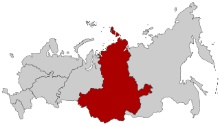
Siberian Federal District is one of the eight federal districts of Russia. Its population was 17,178,298 according to the 2010 Census, living in an area of 4,361,800 square kilometers (1,684,100 sq mi). The entire federal district lies within the continent of Asia.

Jeju City is the capital of the Jeju Province in South Korea and the largest city on Jeju Island. The city is served by Jeju International Airport.

Kolleru Lake is one of the largest freshwater lakes in India and forms the largest shallow freshwater lake in Asia. 15 kilometers away from Eluru and 65 km from Rajamahendravaram, the lake is located between the Krishna and Godavari river deltas. Kolleru Lake is located in the Eluru district in the state of Andhra Pradesh. The lake is fed directly by water from the seasonal Budameru and Tammileru rivulets, and is connected to the Krishna and Godavari irrigation systems by over 67 major and minor irrigation canals. This lake is a major tourist attraction. Many birds migrate here in winter, such as Siberian crane, ibis, and painted storks. The lake was an important habitat for an estimated 20 million resident and migratory birds, including the grey or spot-billed pelican. The lake was declared as a wildlife sanctuary in November 1999 under India's Wildlife Protection Act of 1972, and designated a wetland of international importance in November 2002 under the international Ramsar Convention. The wildlife sanctuary covers an area of 308 km2.
Aegviidu is a borough in Anija Parish, Harju County, Estonia, most known for its picturesque surroundings and hiking trails.

The Nanjing Metro is a rapid transit system serving the urban and suburban districts of Nanjing, the capital city of Jiangsu Province in the People's Republic of China.

The Ganderbal district, is an Indian-administered district in Jammu and Kashmir in the disputed Kashmir region. It was formed in 2007 and has 6 subdistricts (tehsils): Kangan, Ganderbal, Tullamulla, Wakura, Lar, and Gund.

Põhja-Kõrvemaa Nature Reserve is a protected area in Harju County, Northern Estonia, some 50 km east of Tallinn. With an area of 130.9 km2, it is the third largest nature reserve in Estonia. Dominated by forests and bogs, it aims to protect rare and endangered species, their habitats, and valuable natural landscapes.

Jägala Waterfall is a waterfall in northern Estonia on the Jägala River. It is the largest natural waterfall in Estonia, with a width of about 50 meters (160 ft) and a height of about 8 meters (26 ft). Jägala Waterfall is located in Koogi in Harju County. Jägala Waterfall is also the most powerful waterfall in Estonia, cascading 12.8 cubic meters per second (450 cu ft/s) of water. It can even reach 200 cubic meters per second (7,100 cu ft/s) during spring in high water periods. Though, the cascade stops in the winter, freezing over.
Ratva is a village in Alutaguse Parish, Ida-Viru County in northeastern Estonia.

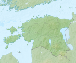
Estonia, officially the Republic of Estonia, is a country by the Baltic Sea in Northern Europe. It is bordered to the north by the Gulf of Finland across from Finland, to the west by the sea across from Sweden, to the south by Latvia, and to the east by Lake Peipus and Russia. The territory of Estonia consists of the mainland, the larger islands of Saaremaa and Hiiumaa, and over 2,300 other islands and islets on the east coast of the Baltic Sea, covering a total area of 45,335 square kilometres (17,504 sq mi). Tallinn, the capital city, and Tartu are the two largest urban areas. The Estonian language is the official language and the first language of the majority of the population of 1.4 million.

Kumari is an Estonian island in Väinameri Sea, and has size of 17,5 ha. It is a part of Matsalu National Park.

Pechorsky District is an administrative and municipal district (raion), one of the twenty-four in Pskov Oblast, Russia. It is located in the northwest of the oblast and borders with Pskovsky District in the northwest, Palkinsky District in the southeast, Alūksne municipality of Latvia in the southwest, and with Võru and Põlva Counties of Estonia in the northwest. Lake Peipus limits the district from the north. The area of the district is 1,251 square kilometers (483 sq mi). Its administrative center is the town of Pechory. Population: 22,123 (2010 Census); 25,300 ; 27,199 (1989 Soviet census). The population of Pechory accounts for 50.6% of the district's total population.
Fashapuyeh District is in Ray County, Tehran province, Iran. Its capital is the city of Hasanabad.

Ruserahu is an uninhabited 31.1 hectares island belonging to Estonia. It is located in Õunaku Bay, 1.5 kilometers southwest of the Õunaku Peninsula, off the southeast coast of the larger island of Hiiumaa. The terrain on Ruserahu is very flat. The island's highest point is 2 meters above sea level. It stretches 0.4 kilometers in a north–south direction, and 0.45 kilometers in an east–west direction. Administratively, it belongs to the village of Esiküla on the island of Kassari, Hiiu Parish, Hiiu County. Ruserahu is part of the Käina Bay-Kassari Landscape Conservation Area.