
The University of Oslo is a public research university located in Oslo, Norway. It is the highest ranked and oldest university in Norway. It is consistently ranked among the top universities in the world and as one of the leading universities of Northern Europe; the Academic Ranking of World Universities ranked it the 58th best university in the world and the third best in the Nordic countries. In 2016, the Times Higher Education World University Rankings listed the university at 63rd, making it the highest ranked Norwegian university.

The Danube Delta is the second largest river delta in Europe, after the Volga Delta, and is the best preserved on the continent. The greater part of the Danube Delta lies in Romania, with a small part in Ukraine. Its approximate surface area is 4,152 square kilometres, of which 3,446 km2 (1,331 sq mi) is in Romania. With the lagoons of Razim–Sinoe, located south of the main delta, the total area of the Danube Delta is 5,165 km2 (1,994 sq mi). The Razim–Sinoe lagoon complex is geologically and ecologically related to the delta proper; the combined territory is listed as a World Heritage Site.

Bear Island is the southernmost island of the Norwegian Svalbard archipelago. The island is located in the western part of the Barents Sea, approximately halfway between Spitsbergen and the North Cape. Bear Island was discovered by Dutch explorers Willem Barentsz and Jacob van Heemskerck on 10 June 1596. It was named after a polar bear that was seen swimming nearby. The island was considered terra nullius until the Spitsbergen Treaty of 1920 placed it under Norwegian sovereignty.
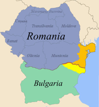
Northern Dobruja is the part of Dobruja within the borders of Romania. It lies between the lower Danube river and the Black Sea, bordered in the south by Southern Dobruja, which is part of Bulgaria.

Lake Illawarra, is an open and trained intermediate wave dominated barrier estuary or large coastal lagoon, is located in the Illawarra region of New South Wales, situated about 100 kilometres (62 mi) south of Sydney, Australia.

Resolute Bay is an Arctic waterway in the Qikiqtaaluk Region, Nunavut, Canada. It is located in Parry Channel on the southern side of Cornwallis Island. The hamlet of Resolute is located on the northern shore of the bay with Resolute Bay Airport to the northwest. The Inuit associated with Resolute Bay are called Qausuittuq and the population of the hamlet in the 2006 census was 229.
Norwegian Geotechnical Institute is an independent international centre for research and consultancy in engineering-related geosciences, integrating geotechnical, geological and geophysical expertise.

Lake Razelm or Lake Razim is the name of a large freshwater lagoon on the shores of the Black Sea in Romania, south of the Danube Delta and part of its World Heritage Site. It is the largest liman in Romania.
The Indian Institute of Remote Sensing is a premier institute for research, higher education and training in the field of remote sensing, geoinformatics and GPS technology for natural resources, environmental and disaster management under the Indian Department of Space, which was established in the year 1966. It is located in the city of Dehradun, Uttarakhand.
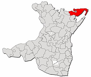
Mihai Viteazu is a commune in Constanța County, Northern Dobruja, Romania. It is situated in the northeastern part of the county, some 60 km (37 mi) from the county seat, Constanța. To the east are the shores of the Black Sea and of Lake Sinoe, while to the north is Tulcea County.
Ralph Brazelton Peck was a civil engineer specializing in soil mechanics. He was awarded the National Medal of Science in 1976 "for his development of the science and art of subsurface engineering, combining the contributions of the sciences of geology and soil mechanics with the practical art of foundation design"?

The Northern Gulf Institute (NGI) is a National Oceanic and Atmospheric Administration (NOAA) Cooperative Institute started in October 2006. It is one of 20 NOAA Cooperative Institutes (CIs). The NGI is a partnership of six academic institutions and NOAA. The collaboration led by Mississippi State University (MSU), includes the University of Southern Mississippi (USM), Louisiana State University (LSU), Florida State University (FSU), the University of Alabama in Huntsville, and the Dauphin Island Sea Lab (DISL). The NGI defines the Northern Gulf of Mexico region as the upland, watershed, coastal zone, and coastal ocean areas from the Sabine River in Louisiana east to the Suwannee River in Florida.
The International Centre for Geohazards (ICG) is a Norwegian, multidisciplinary research and educational institute, hosted at the Norwegian Geotechnical Institute (NGI). According to the institute's website, ICG's research activities focus on the assessment, prevention and mitigation of geohazards, in which the latter is defined as a geological state that represents or has the potential to develop further in a situation leading to damage or uncontrolled risk. From this definition, it becomes clear that geohazards are widespread, both spatially and temporally, and are always related to geological conditions and processes in both offshore, coastal and onshore environments.

The Department of Civil and Environmental Engineering is the academic department at Imperial College London dedicated to civil engineering. It is located at the South Kensington Campus in London, along Imperial College Road. The department is currently a part of the college's Faculty of Engineering, which was formed in 2001 when Imperial College restructured. The department has consistently ranked within the top five on the QS World University Rankings in recent years.
Carmen Gaina is the Director of the Centre for Earth Evolution and Dynamics (CEED) a Norwegian Centre of Excellence hosted at the Department of Geosciences, University of Oslo, Norway.

Suction caissons are a form of fixed platform anchor in the form of an open bottomed tube embedded in the sediment and sealed at the top while in use so that lifting forces generate a pressure differential that holds the caisson down. They have a number of advantages over conventional offshore foundations, mainly being quicker to install than deep foundation piles and being easier to remove during decommissioning. Suction caissons are now used extensively worldwide for anchoring large offshore installations, like oil platforms, offshore drillings and accommodation platforms to the seafloor at great depths. In recent years, suction caissons have also seen usage for offshore wind turbines in shallower waters.

Harsh Kumar Gupta is an Indian earth scientist and seismologist, known for his pioneering work on estimation of reservoir-induced earthquakes. He is a former vice chancellor of the Cochin University of Science and Technology (CUSAT) and a Raja Ramanna Fellow at the National Geophysical Research Institute (NGRI), Hyderabad. A recipient of the 1983 Shanti Swarup Bhatnagar Prize for Science and Technology, the highest Indian award in the science and technology category, and the 2008 Waldo E. Smith Award, Gupta was awarded the fourth highest Indian civilian honour of the Padma Shri in 2006.
Suzanne Lacasse is a Canadian civil engineer. She obtained her PhD in 1976.

Geological engineering is a discipline of engineering concerned with the application of geological science and engineering principles to fields, such as civil engineering, mining, environmental engineering, and forestry, among others. The work of geological engineers often directs or supports the work of other engineering disciplines such as assessing the suitability of locations for civil engineering, environmental engineering, mining operations, and oil and gas projects by conducting geological, geoenvironmental, geophysical, and geotechnical studies. They are involved with impact studies for facilities and operations that affect surface and subsurface environments. The engineering design input and other recommendations made by geological engineers on these projects will often have a large impact on construction and operations. Geological engineers plan, design, and implement geotechnical, geological, geophysical, hydrogeological, and environmental data acquisition. This ranges from manual ground-based methods to deep drilling, to geochemical sampling, to advanced geophysical techniques and satellite surveying. Geological engineers are also concerned with the analysis of past and future ground behaviour, mapping at all scales, and ground characterization programs for specific engineering requirements. These analyses lead geological engineers to make recommendations and prepare reports which could have major effects on the foundations of construction, mining, and civil engineering projects. Some examples of projects include rock excavation, building foundation consolidation, pressure grouting, hydraulic channel erosion control, slope and fill stabilization, landslide risk assessment, groundwater monitoring, and assessment and remediation of contamination. In addition, geological engineers are included on design teams that develop solutions to surface hazards, groundwater remediation, underground and surface excavation projects, and resource management. Like mining engineers, geological engineers also conduct resource exploration campaigns, mine evaluation and feasibility assessments, and contribute to the ongoing efficiency, sustainability, and safety of active mining projects

