
Hetch Hetchy is a valley, a reservoir, and a water system in California in the United States. The glacial Hetch Hetchy Valley lies in the northwestern part of Yosemite National Park and is drained by the Tuolumne River. For thousands of years before the arrival of settlers from the United States in the 1850s, the valley was inhabited by Native Americans who practiced subsistence hunting-gathering. During the late 19th century, the valley was renowned for its natural beauty – often compared to that of Yosemite Valley – but also targeted for the development of water supply for irrigation and municipal interests. The controversy over damming Hetch Hetchy became mired in the political issues of the day. The law authorizing the dam passed Congress on December 7, 1913.

The Feather River is the principal tributary of the Sacramento River, in the Sacramento Valley of Northern California. The river's main stem is about 73 miles (117 km) long. Its length to its most distant headwater tributary is just over 210 miles (340 km). The main stem Feather River begins in Lake Oroville, where its four long tributary forks join—the South Fork, Middle Fork, North Fork, and West Branch Feather Rivers. These and other tributaries drain part of the northern Sierra Nevada, and the extreme southern Cascades, as well as a small portion of the Sacramento Valley. The total drainage basin is about 6,200 square miles (16,000 km2), with approximately 3,604 square miles (9,330 km2) above Lake Oroville.

Lake Oroville is a reservoir formed by the Oroville Dam impounding the Feather River, located in Butte County, northern California. The lake is situated 5 miles (8 km) northeast of the city of Oroville, within the Lake Oroville State Recreation Area, in the western foothills of the Sierra Nevada. Known as the second-largest reservoir in California, Lake Oroville is treated as a keystone facility within the California State Water Project by storing water, providing flood control, recreation, freshwater releases to assist in controlling the salinity intrusion into the Sacramento-San Joaquin Delta and protecting fish and wildlife.
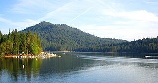
Bass Lake is located in the Sierra National Forest, of Madera County, California, approximately 14 mi (23 km) south of the entrance to Yosemite National Park. The lake is approximately four miles long and one-half mile wide.

Mammoth Pool Reservoir is a reservoir on the San Joaquin River in the Sierra Nevada, within the Sierra National Forest in California. It creates the border between Fresno County and Madera County. It is about 45 miles (72 km) north-northeast of Fresno.
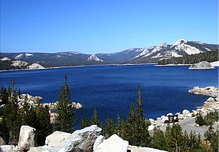
Courtright Reservoir is a reservoir in Fresno County, California. The reservoir is at an elevation of 8,170 feet in the Sierra National Forest, in the Sierra Nevada Mountain Range, bordering the John Muir Wilderness and the Dinkey Lakes Wilderness.
Englebright Dam is a 280 ft (85 m) high variable radius concrete arch dam on the Yuba River in the Sacramento River Basin, located in Yuba and Nevada counties of California, United States. It was put into service in 1941 by the United States Army Corps of Engineers.

The Bear River is a tributary of the Feather River in the Sierra Nevada, winding through four California counties: Yuba, Sutter, Placer, and Nevada. About 73 miles (117 km) long, the river flows generally southwest through the Sierra then west through the Central Valley, draining a narrow, rugged watershed of 295 square miles (760 km2).
Mammoth Pool Dam is a hydroelectric dam located on the San Joaquin River in the southern Sierra Nevada mountain range of California, about 45 miles (72 km) northeast of Fresno. It forms Mammoth Pool Reservoir and lies within the Sierra National Forest. The dam and reservoir were named after a large natural pool in the river that was once located above the present dam site.

The North Fork Kings River is a 40.3-mile (64.9 km) tributary of the Kings River, in the U.S. state of California. The river's main stem is entirely within Fresno County, and its watershed drains about 387 square miles (1,000 km2) of the southern Sierra Nevada mountain range.

The Big Creek Hydroelectric Project is an extensive hydroelectric power scheme on the upper San Joaquin River system, in the Sierra Nevada of central California. The project is owned and operated by Southern California Edison (SCE). The use and reuse of the waters of the San Joaquin River, its South Fork, and the namesake of the project, Big Creek – over a vertical drop of 6,200 ft (1,900 m) – have over the years inspired a nickname, "The Hardest Working Water in the World".
Wishon Dam is a dam in Fresno County, California in the Sierra National Forest, in the Sierra Nevada Mountain Range. It impounds the North Fork Kings River to form Wishon Reservoir.

Rollins Dam is a dam on the border of Nevada and Placer counties in northern California, in the United States.

Beardsley Dam is a dam on the Middle Fork Stanislaus River in Tuolumne County, California. The site is surrounded by the Stanislaus National Forest.

Bear River Dam is a dam in Amador County, California, due east of Sacramento.
Strawberry Dam, also known as Main Strawberry Dam, is a dam in Tuolumne County, California.
Slab Creek Dam is a dam in the American River watershed of the central Sierra Nevada, within El Dorado County, California.

O'Shaughnessy Dam is a 430-foot (131 m) high concrete arch-gravity dam in Tuolumne County, California, United States. It impounds the Tuolumne River, forming the Hetch Hetchy Reservoir at the lower end of Hetch Hetchy Valley in Yosemite National Park, about 160 miles (260 km) east of San Francisco. The dam and reservoir are the source for the Hetch Hetchy Aqueduct, which provides water for over two million people in San Francisco and other municipalities of the west Bay Area. The dam is named for engineer Michael O'Shaughnessy, who oversaw its construction.

The Yuba–Bear Hydroelectric Project is a complex hydroelectric scheme in the northern Sierra Nevada in California, tapping the upper Yuba River and Bear River drainage basins. The project area encompasses approximately 400 square miles (1,000 km2) in Nevada, Placer, and Sierra Counties. Owned by the Nevada Irrigation District, it consists of 16 storage dams plus numerous diversion and regulating dams, and four generating stations producing 425 million kilowatt hours of electricity each year. The Yuba–Bear Hydroelectric Project consists of the Bowman development, Dutch Flat No. 2 development, Chicago Park development, and Rollins development.

The Upper North Fork Feather River Project is a hydroelectric scheme in the Sierra Nevada of California, within Lassen and Plumas Counties. The project consists of three dams, five power plants, and multiple conduits and tunnels in the headwaters of the North Fork Feather River, a major tributary of the Feather—Sacramento River systems. The total installed capacity is 362.3 megawatts (MW), producing an annual average of 1,171.9 gigawatt hours (GWh). The project is also contracted for the delivery of irrigation water between March 31 and October 31 of each year. The project is owned and operated by Pacific Gas and Electric Company.


