
Aoraki / Mount Cook National Park is a national park located in the central-west of the South Island of New Zealand. It was established in October 1953 and takes its name from the highest mountain in New Zealand, Aoraki / Mount Cook. The area of the park is 707 km2 (273 sq mi), and it shares a border with Westland Tai Poutini National Park along the Main Divide of the Southern Alps. The national park consists of reserves that were established as early as 1885 to protect the area's significant landscape and vegetation. Glaciers cover 40% of the park, including the county's largest glacier, Haupapa / Tasman Glacier. In 1990, the park was included in the area designated as the Te Wāhipounamu World Heritage Site. The park is managed by the Department of Conservation (DOC) alongside Ngāi Tahu, the iwi who are mana whenua in the region.

Fiordland National Park is a national park in the south-west corner of South Island of New Zealand. It is the largest of the 13 national parks in New Zealand, with an area covering 12,607 km2 (4,868 sq mi), and a major part of the Te Wāhipounamu a UNESCO World Heritage Site established in 1990. The park is administered by the Department of Conservation. The southern ranges of the Southern Alps cover most of Fiordland National Park, combined with the deep glacier-carved valleys.

The Haast River / Awarua is a river on the West Coast of the South Island of New Zealand. The Māori name for the river is Awarua. It drains the western watershed of the Haast Pass. The Haast River is 100 kilometres (62 mi) in length, and enters the Tasman Sea near Haast township. The river's main tributary is the Landsborough River.

The Catlins comprise an area in the southeastern corner of the South Island of New Zealand. The area lies between Balclutha and Invercargill, straddling the boundary between the Otago and Southland regions. It includes the South Island's southernmost point, Slope Point.

Lake Matheson is a small glacial lake in South Westland, New Zealand, near the township of Fox Glacier. It was a traditional food-gathering place for local Māori. An easy walking track circles the lake, which is famous for its reflected views of Aoraki / Mount Cook and Mount Tasman.

The Purakaunui Falls are a cascading three-tiered waterfall on the Purakaunui River, in The Catlins of the southern South Island of New Zealand. As one of very few South Island waterfalls away from the alpine region, it has long been a popular destination and photographic subject.

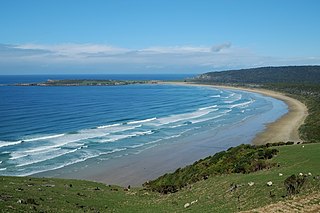
Curio Bay is a coastal embayment in the Southland District of New Zealand, best known as the site of a petrified forest some 180 million years old. It also hosts a yellow-eyed penguin colony, arguably the rarest of penguin species, with approximately 1600 breeding pairs in the extant population. The bay, along with neighbouring Porpoise Bay, is home to the endemic Hector's dolphin. Southern right whales are occasionally observed offshore, as on numerous parts of the country's coast. Located near the southernmost point of the South Island, Curio Bay is one of the major attractions in the Catlins, attracting around 100,000 visitors per year. The town of Waikawa has an information centre for tourists.
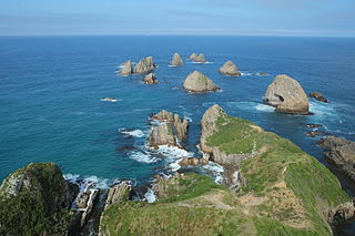
Nugget Point is one of the most iconic landforms on the Otago coast in New Zealand. Located at the northern end of the Catlins coast, along the road from Kaka Point, this steep headland has a lighthouse at its tip, surrounded by rocky islets. The point is home to many seabirds, including penguins, gannets and royal spoonbills, and a large breeding colony of fur seals. Roaring Bay, on the south coast of the tip of Nugget Point, is home to a small colony of yellow-eyed penguins.
The Catlins Ranges are a series of rugged, roughly parallel hill ranges in the southeastern corner of New Zealand's South Island.
Tautuku Peninsula is a rocky headland in the Catlins on the south coast of Otago on the South Island of New Zealand. It is located 25 km (15 mi) east of Waikawa, at the western end of Tautuku Bay.
Lake Mahinapua is a shallow lake on the West Coast of New Zealand's South Island. Once a lagoon at the mouth of the Hokitika River, it became a lake when the river shifted its course. Lake Māhinapua was the site of a significant battle between Ngāi Tahu and Ngāti Wairangi Māori, and is regarded by them as a sacred site where swimming and fishing are prohibited. In European times it was part of an inland waterway that carried timber and settlers between Hokitika and Ross until the building of the railway. Today it is protected as a scenic reserve for boating, camping, and hiking.

Ben Lomond is a mountain close to Queenstown, New Zealand. It was named after Ben Lomond in Scotland by the early shepherd Duncan McAusland. The summit is approximately 4 km (2.5 mi) northwest of the town centre and reaches a height of 1,748 metres (5,735 ft). Connected to Ben Lomond are the large but slightly shorter Bowen Peak and Bob's Peaks, while nearby is the dominant feature of Queenstown Hill. There are scenic views available from a range of places on the mountain with the top giving a 360-degree panorama of much of the Wakatipu Basin including Lake Wakatipu, The Remarkables Mountains, Cecil Peak and Walter Peak.

The Southern Scenic Route is a tourist highway in New Zealand linking Queenstown, Fiordland, Te Anau and the iconic Milford Road to Dunedin via, Riverton, Invercargill and The Catlins. An Australian travel magazine labelled it "one of the world's great undiscovered drives" in 2008.
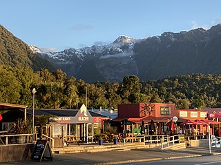
Fox Glacier, called Weheka until the 1940s, is a village on the West Coast of the South Island of New Zealand. The village is close to the eponymous Fox Glacier / Te Moeka o Tuawe.

The McLean Falls on the Tautuku River in Catlins Forest Park descend a number of steep drop offs and terraces, with the very top of the waterfall, where it meets its first waterpool being 22-metres. It then descends for many more metres over a series of terraces. The McLean Falls are often described as the most spectacular in the region. However, its sister waterfall Purakaunui Falls is more visited, due to it being more easily accessible.

Pirongia Forest Park is a protected area 30 km southwest of Hamilton, New Zealand. It covers 167.7 square kilometres (64.7 sq mi) across four blocks of land - Pirongia, Te Maunga O Karioi Block, and the small Mangakino Block and Te Rauamoa Block. The park encompasses Mount Pirongia west of Pirongia and Mount Karioi near the coast southwest of Raglan. Wairēinga / Bridal Veil Falls Scenic Reserve is located nearby, but is separate to Pirongia Forest Park.

The Southland temperate forests is a temperate broadleaf and mixed forests ecoregion on New Zealand's South Island. The natural vegetation was mostly forest, but over the centuries human activities, including grazing and fires, replaced much of the original forest with grassland and agriculture.

Otago Youth Adventure Trust is a trust that operates three outdoor education camps in the Otago region of the South Island of New Zealand. The Trust was established in 1968 and owns Tautuku Outdoor Education Centre near Tautuku Beach in the Catlins, Berwick Lodge in Berwick Forest, Sutton in Middlemarch. The camps are used year-round, and are mostly used by school groups during the week, and are generally available for booking by work places and private groups at the weekend. The Trust is run by volunteers, and relies on donations from Rotary Clubs, Lions Clubs and other similar organisations for funding to maintain the facilities.

Te Matuku Marine Reserve is a marine reserve administered by the New Zealand Department of Conservation. It includes Te Matuku Bay, one of the largest and least disturbed estuaries on Waiheke Island, as well as a surrounding area of sea. It covers an area of 690 ha and was established in 2003.

Ship Creek is a small river that flows into an area of coastal swamp forest on the West Coast of New Zealand's South Island. Ship Creek is approximately 11 km (6.8 mi) long and flows northwest from catchment areas on the slopes of Bald Hill, reaching the Tasman Sea around 20 km (12 mi) north-east of Haast. Near the mouth of Ship Creek, there are short walks around dune lakes and ancient kahikatea swamp forest.

