Lakhenpur

Last updated

Lakhanpur

Lakhanpur
city
India Jammu and Kashmir location map UN view.svg
Red pog.svg
Lakhanpur
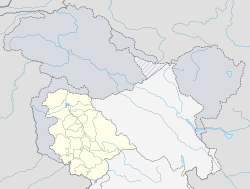
Location in Jammu and Kashmir, India
India location map.svg
Red pog.svg
Lakhanpur
Lakhanpur (India)
Coordinates: 32°24′38″N75°36′52″E / 32.410561°N 75.614403°E / 32.410561; 75.614403 Coordinates: 32°24′38″N75°36′52″E / 32.410561°N 75.614403°E / 32.410561; 75.614403
CountryFlag of India.svg  India
State Jammu and Kashmir
District Kathua
Population
(2001)
  Total1,521
Languages
  Official Urdu
Time zone UTC+5:30 (IST)

Lakhanpur is a town and a notified area committee in Kathua district in the Indian state of Jammu and Kashmir. Lakhanpur is the entrance to Jammu and Kashmir from Punjab and rest of India. It is a sparsely populated area about 20 kilometers from the center of Kathua district. Since it is the entrance of Jammu and Kashmir, a passage to and from Jammu and Kashmir, tolls are collected here.

Kathua district District of Jammu and Kashmir in India

Kathua district is one of 22 administrative districts that comprise the Indian state of Jammu and Kashmir. It is surrounded by Jammu to the northwest, the Doda and Udhampur districts to the north, the state of Himachal Pradesh to the east, Punjab to the south, and Pakistan's working boundary to the west. Its terrain is diverse, consisting of rich agricultural areas along the Punjab/Kashmir border, plains sweeping eastward to the foothills of the Himalaya, and the mountainous Pahari region in the east.

India Country in South Asia

India, also known as the Republic of India, is a country in South Asia. It is the seventh largest country by area and with more than 1.3 billion people, it is the second most populous country as well as the most populous democracy in the world. Bounded by the Indian Ocean on the south, the Arabian Sea on the southwest, and the Bay of Bengal on the southeast, it shares land borders with Pakistan to the west; China, Nepal, and Bhutan to the northeast; and Bangladesh and Myanmar to the east. In the Indian Ocean, India is in the vicinity of Sri Lanka and the Maldives, while its Andaman and Nicobar Islands share a maritime border with Thailand and Indonesia.

Jammu and Kashmir State in India

Jammu and Kashmir is a state in northern India, often denoted by its acronym, J&K. It is located mostly in the Himalayan mountains, and shares borders with the states of Himachal Pradesh and Punjab to the south. The Line of Control separates it from the Pakistani-administered territories of Azad Kashmir and Gilgit-Baltistan in the west and north respectively, and a Line of Actual Control separates it from the Chinese-administered territory of Aksai Chin in the east. The state has special autonomy under Article 370 of the Constitution of India.
Contents

Geography

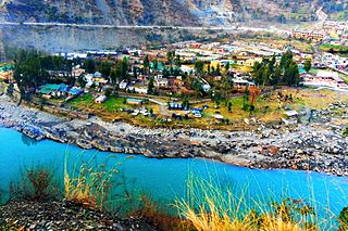
Lakhanpur is situated just below the Sivalik Hills. The town is sandwiched between Ravi river to the south and east while the Shiwaliks rise abruptly 400 metres (1,300 ft) high to the north. The town starts from the Modhopur Ravi bridge and is spread on both the sides of NH1A. Kathua city is just 6 km ahead of Lakhenpur.

Sivalik Hills mountain range

The Sivalik Hills, also known as Churia Hills, are a mountain range of the outer Himalayas that stretches from the Indus River about 2,400 km (1,500 mi) eastwards close to the Brahmaputra River. It is 10–50 km (6.2–31.1 mi) wide with an average altitude of 1,500–2,000 m (4,900–6,600 ft). Between the Teesta and Raidāk Rivers in Assam is a gap of about 90 km (56 mi). In some Sanskrit texts, the region is called Manak Parbat. Sivalik literally means 'tresses of Shiva’.

Traffic and infrastructure

Since the town is an entrance to the state, the infrastructure is well developed with parking, restaurants, banks, ATMs, sanitation facilities and much more. But the traffic problem is difficult, with hours of traffic snarls due to the huge rush of trucks, buses and cars. The toll plaza serves as a source of income to the state as well. Other than one of the major toll collecting plazas in the state, The town is also known for its fort, hence the name lakhanpur fort which is now turned into a devi temple.

Demographics

As of 2001 India census, [1] Lakhenpur had a population of 1521. Males constitute 53% of the population and females 47%. Lakhanpur has an average literacy rate of 77%, higher than the national average of 59.5%: male literacy is 81%, and female literacy is 73%. In Lakhenpur, 12% of the population is under 6 years of age.

Census Acquiring and recording information about the members of a given population

A census is the procedure of systematically acquiring and recording information about the members of a given population. The term is used mostly in connection with national population and housing censuses; other common censuses include agriculture, business, and traffic censuses. The United Nations defines the essential features of population and housing censuses as "individual enumeration, universality within a defined territory, simultaneity and defined periodicity", and recommends that population censuses be taken at least every 10 years. United Nations recommendations also cover census topics to be collected, official definitions, classifications and other useful information to co-ordinate international practice.

Religion

Hindu 89.28%, Sikh 3.18%, Muslim 5.11%, [2]

Related Research Articles

Uri, Jammu and Kashmir Town in Jammu and Kashmir, India

Uri is a town and a tehsil in the Baramulla district, in the Indian state of Jammu and Kashmir. Uri is located on the left bank of the Jhelum River, about 10 kilometres (6.2 mi) east of the Line of Control with Pakistan.

Doda City in Jammu and Kashmir, India

Doda is a town and a notified area committee in Doda district in the Indian state of Jammu and Kashmir. Doda is located at 33.13°N 75.57°E and has an average elevation of 1,107 metres (3631 feet). The town has a mixed population of Kashmiri and its dialect i.e. Sarazi-speaking people. It is surrounded by mountains from all sides giving it a valley look.

Bari Brahmana city in Jammu and Kashmir, India

Bari Brahmana is a town and a notified area committee in Samba district in the state of Jammu & Kashmir, India. The Industrial city has become the largest manufacturing centre of Jammu and Kashmir. Bari Brahmana has the largest number of industries in the state with a great share in industrial GDP of state. The name of the town is derived from two Dogri words 'Bari' meaning open ground and 'Brahmana' meaning Brahmins. Thus the name means 'the garden of Brahmins.'

Basholi Town in Jammu and Kashmir, India

Basholi (Basoli) is a town in Kathua district in the state of Jammu and Kashmir, India. It is situated on the right bank of River Ravi at an altitude of 1876 ft. It was founded by Raja Bhupat Pal sometime in 1635. It was known for magnificent palaces which are now in ruins and miniatures paintings. A famous Sikh-Mughal battle Battle of Basoli was fought at Basoli.

Billawar City in Jammu and Kashmir, India

Billawar is a town and a notified area committee in Kathua district of the Indian state of Jammu and Kashmir. Billawar is also a tehsil. It is also known as Balaur. Billawar was founded by Raja Bhog Pal in the 7th century A.D and it remained the capital of Basohli Rajas. The descendants of the Royal family are known as " Baloria, Balowria, Balouria or Billawaria" and chandel all being the modern day spelling variants. The town has some ancient monuments. One of these is Mahabilvakeshwar Temple, one of the most revered Shiva temples of the area. It was known as Hari Hara Temple.

Hiranagar city in Jammu and Kashmir, India

Hiranagar is a town and a notified area committee in Kathua district in the Indian state of Jammu and Kashmir. It is a tehsil headquarters. It is named after Raja Hira Singh, son of Raja Dhyan Singh and nephew of Raja Gulab Singh.

Jammu Cantonment city in Jammu and Kashmir, India

Jammu Cantonment is a cantonment town in Jammu District in the Indian state of Jammu and Kashmir.

Jourian town in Jammu and Kashmir, India

Jourian is a town and a notified area committee in Jammu district in the Indian state of Jammu and Kashmir.

Nowshera, Jammu and Kashmir city in Jammu and Kashmir, India

Nowshera is a town and tehsil in the Rajauri district in the Indian state of Jammu and Kashmir. It is governed by a Municipal committee.

Parole, India town in Jammu and Kashmir, India

Parole is a town and a notified area committee in Kathua district in the Indian state of Jammu and Kashmir.

Sujanpur CITY in pathankotPunjab, India

Sujanpur is City (ਸ਼ਹਿਰ) & municipal council in District Pathankot in the Indian state of Punjab India). It is 10Km from Pathankot towards Jammu on Jalandhar-Jammu-Amritsar National Highway (NH-1A). It is situated near the banks of Ravi river, and surrounded by two canals: UBDC and Bias Link.

Vijay Pur, Jammu and Kashmir city in Jammu and Kashmir, India

Vijay Pur is a town and a notified area committee in Samba district in the Indian state of Jammu and Kashmir, situated on the bank of Devak river, known locally as Gupt Ganga. It is one of the most fast growing town near Jammu.

Khan Sahib, Jammu and Kashmir city in Jammu and Kashmir, India

Khan Sahib is a town and a notified area committee in Badgam district in the Indian state of Jammu and Kashmir.

Ramban (Jammu and Kashmir) Town in Jammu and Kashmir, India

Wikipedia:WikiProject Indian cities

Samba, Jammu and Kashmir Place in Jammu and Kashmir, India

Samba is a city in the only sub-district "Samba Tahsil" of the Samba District in the Indian state of Jammu and Kashmir. With population of about 13 thousand, Samba is the third least populous municipal committee in the district. The total geographical area of Samba is 2 km2 and it is the second smallest city by area in the sub district. The city is divided into 13 wards for which elections are held every 5 years. Among the 13 wards, Samba Ward No. 13 is the most populous ward with a population of 1,702 and Samba Ward No. 11 is the least populous ward with a population of 533.

Samba district District of Jammu and Kashmir in India

Samba District is a newly formed district in the Indian state of Jammu and Kashmir. Before its formation, this area was part of Jammu district and Kathua district.

Chowki Choura, Akhnoor is a Sub-Division in Jammu district in the state of Jammu & Kashmir, India.

Chak Dayala Town in Jammu & Kashmir, India

Chack Diyalla or Chakdyala is a village in the Indian Jammu and Kashmir. It is located in Hiranagar tehsil of Kathua district.

References

  1. "Census of India 2001: Data from the 2001 Census, including cities, villages and towns (Provisional)". Census Commission of India. Archived from the original on 2004-06-16. Retrieved 2008-11-01.
  2. http://www.census2011.co.in