
Guna is a city and a municipality in Guna district in the Indian state of Madhya Pradesh. It is the administrative headquarters of Guna District and is located on the banks of Parbati river.

Angul is a town and a municipality and the headquarters of Angul district in the state of Odisha, India. Angul has an average elevation of 195 m (640 ft) above sea level. The total geographical area of the district is 6232 km2. From the point of view of area, it stands 11th among the 30 Districts of Odisha.
Malkangiri historically known as 'Malikamardhangiri' is a town and a Municipality in Malkangiri district in the Indian state of Odisha. It is the headquarters of the Malkangiri district. Malkangiri is the new home of the East Pakistani refugees, who were rehabilitated since 1965 under the Dandakaranya Project. Also some Sri Lankan Tamil refugees were rehabilitated in Malkangiri town, following the armed struggle of LTTE in the early 1990s. Currently it is one of the most naxalite-affected areas of the state and is a part of the Red Corridor.
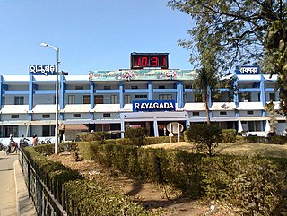
Rayagada is a municipality in Rayagada district in the Indian state of Odisha. It is the administrative headquarters of Rayagada district.
Bhuban is a town and a NAC, located in the subdivision of Kamakhyanagar, Dhenkanal district in the state of Odisha, India.
Binika is a town and a notified area council in Subarnapur district in the state of Odisha, India.
Chikiti is a town and a notified area council located in Ganjam district in the state of Odisha, India.
Daitari is a census town in Kendujhar district in the state of Odisha, India.
Hinjilicut is a town and municipality of Ganjam district in the Indian state of Odisha.
Kabisuryanagar is a town and a NAC in Ganjam district in the Indian state of Odisha.

Khallikote is a town and a Notified Area Council in Ganjam district in the Indian state of Odisha.
Khandapada is a town and a notified area committee in Nayagarh district in the Indian state of Odisha. It is located in the valley of nine mountains.
Kiraoli is a town and a nagar panchayat in Agra district in the Indian state of Uttar Pradesh.
Kodala is a town and a Notified Area Council in Ganjam District in the Indian State of Odisha.
Padampur is a town and a notified area in Bargarh district in the Indian state of Odisha.
Pipili is a town and a NAC under jurisdiction of Puri district in the Indian state of Odisha. It is famous for designing beautiful Applique handicrafts. It is a town of artisans famous for their colourful fabrics.
Purusottampur is a town and a Notified Area Council in Ganjam district in the Indian state of Odisha.

Talcher is one of the 4 sub-divisions of Angul district in the Indian state of Odisha.
Titilagarh is a town and Municipality in Balangir district in the Indian state of Odisha.
Chadiapada is a small village in Ganjam district of Odisha, India.
