Mutne is a village in the administrative district of Gmina Jeleśnia, within Żywiec County, Silesian Voivodeship, in southern Poland. It lies approximately 2 kilometres (1 mi) west of Jeleśnia, 9 km (6 mi) south-east of Żywiec, and 70 km (43 mi) south of the regional capital Katowice.
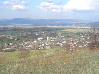
Radziechowy is a village in the administrative district of Gmina Radziechowy-Wieprz, within Żywiec County, Silesian Voivodeship, in southern Poland. It lies approximately 8 kilometres (5 mi) south-west of Żywiec and 68 km (42 mi) south of the regional capital Katowice. The village has a population of approximately 5,000.

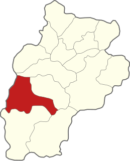
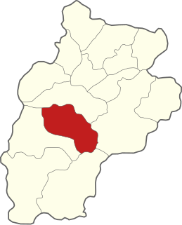
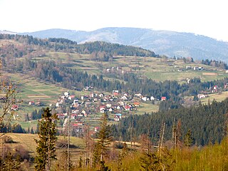
Gmina Radziechowy-Wieprz is a rural gmina in Żywiec County, Silesian Voivodeship, in southern Poland. Its seat is the village of Wieprz, which lies approximately 7 kilometres (4 mi) south of Żywiec and 70 km (43 mi) south of the regional capital Katowice.

Gmina Rajcza is a rural gmina in Żywiec County, Silesian Voivodeship, in southern Poland, on the Slovak border. Its seat is the village of Rajcza, which lies approximately 22 kilometres (14 mi) south of Żywiec and 83 km (52 mi) south of the regional capital Katowice.

Gmina Ujsoły is a rural gmina in Żywiec County, Silesian Voivodeship, in southern Poland, on the Slovak border. Its seat is the village of Ujsoły, which lies approximately 26 kilometres (16 mi) south of Żywiec and 88 km (55 mi) south of the regional capital Katowice.
Gmina Węgierska Górka is a rural gmina in Żywiec County, Silesian Voivodeship, in southern Poland. Its seat is the village of Węgierska Górka, which lies approximately 12 kilometres (7 mi) south-west of Żywiec and 73 km (45 mi) south of the regional capital Katowice.

Milówka is a village in Żywiec County, Silesian Voivodeship, in southern Poland. It is the seat of the gmina called Gmina Milówka. It lies It is situated in the Żywiec Beskids mountain range, approximately 18 kilometres (11 mi) south-west of Żywiec and 78 km (48 mi) south of the regional capital Katowice. The village has a population of approximately 4,300. Well-known Polish musical group Golec uOrkiestra hails from here.
Sopotnia Mała is a village in the administrative district of Gmina Jeleśnia, within Żywiec County, Silesian Voivodeship, in southern Poland. It lies approximately 7 kilometres (4 mi) south-west of Jeleśnia, 11 km (7 mi) south-east of Żywiec, and 75 km (47 mi) south of the regional capital Katowice.

Pietrzykowice is a village in the administrative district of Gmina Łodygowice, within Żywiec County, Silesian Voivodeship, in southern Poland. It lies approximately 5 kilometres (3 mi) south of Łodygowice, 5 km (3 mi) west of Żywiec, and 64 km (40 mi) south of the regional capital Katowice. The village has a population of 4,279.

Kamesznica is a village in the administrative district of Gmina Milówka, within Żywiec County, Silesian Voivodeship, in southern Poland. It lies approximately 5 kilometres (3 mi) west of Milówka, 20 km (12 mi) south-west of Żywiec, and 77 km (48 mi) south of the regional capital Katowice.
Nieledwia is a village in the administrative district of Gmina Milówka, within Żywiec County, Silesian Voivodeship, in southern Poland. It lies approximately 3 kilometres (2 mi) south-west of Milówka, 19 km (12 mi) south-west of Żywiec, and 79 km (49 mi) south of the regional capital Katowice.

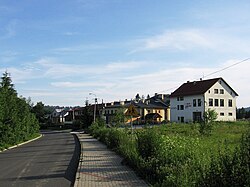
Przybędza is a village in the administrative district of Gmina Radziechowy-Wieprz, within Żywiec County, Silesian Voivodeship, in southern Poland. It lies approximately 11 kilometres (7 mi) south-west of Żywiec and 71 km (44 mi) south of the regional capital Katowice.

Rycerka Górna is a village in the administrative district of Gmina Rajcza, within Żywiec County, Silesian Voivodeship, in southern Poland, close to the border with Slovakia. It lies approximately 7 kilometres (4 mi) south-west of Rajcza, 28 km (17 mi) south-west of Żywiec, and 87 km (54 mi) south of the regional capital Katowice.

Sól is a village in the administrative district of Gmina Rajcza, within Żywiec County, Silesian Voivodeship, in southern Poland, close to the border with Slovakia. It lies approximately 6 kilometres (4 mi) south-west of Rajcza, 26 km (16 mi) south-west of Żywiec, and 85 km (53 mi) south of the regional capital Katowice.

Młada Hora is a village in the administrative district of Gmina Ujsoły, within Żywiec County, Silesian Voivodeship, in southern Poland, close to the border with Slovakia.
Stawiska is a village in the administrative district of Gmina Ujsoły, within Żywiec County, Silesian Voivodeship, in southern Poland, close to the border with Slovakia. It lies approximately 3 kilometres (2 mi) west of Ujsoły, 26 km (16 mi) south of Żywiec, and 87 km (54 mi) south of the regional capital Katowice.

Cięcina is a village in the administrative district of Gmina Węgierska Górka, within Żywiec County, Silesian Voivodeship, in southern Poland. It lies approximately 12 km (7 mi) south-west of Żywiec and 73 km (45 mi) south of the regional capital Katowice. The village has a population of 4,373.

Cisiec is a village in the administrative district of Gmina Węgierska Górka, within Żywiec County, Silesian Voivodeship, in southern Poland. It lies approximately 4 kilometres (2 mi) south-west of Węgierska Górka, 15 km (9 mi) south-west of Żywiec, and 75 km (47 mi) south of the regional capital Katowice.