
Kington Magna is a village and civil parish in the Blackmore Vale area of Dorset, England, about 3+1⁄2 miles southwest of Gillingham.

Abbotsbury is a village and civil parish in the English county of Dorset. The settlement is in the unitary authority of Dorset about 1 mile (1.6 km) inland from the English Channel coast. The village, including Chesil Beach, the swannery and subtropical gardens, is owned by the Ilchester Estate, which owns 61 square kilometres of land in Dorset. In the 2011 census the civil parish had a population of 481.

Corscombe is a village and civil parish in the English county of Dorset, in the Dorset Council administrative area. The parish includes the small settlements of Benville and Toller Whelme to the south and in the 2011 census had a population of 445.

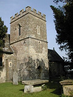
Chalbury is a village in the English county of Dorset. It lies on the southern edge of Cranborne Chase within the East Dorset administrative district of the county, four miles north of Wimborne Minster and four miles west of Verwood. The village is sited on Chalbury Hill, the view from which has been described as "one of the most fascinating in the county". The Dorset broadcaster Ralph Wightman wrote of the hill and its view:
Fifehead Magdalen is a small village and civil parish in the county of Dorset in southern England. It lies within the Blackmore Vale, about three miles south-southwest of Gillingham and five miles west of Shaftesbury. It is sited on Corallian limestone soil and surrounded by Oxford Clay, about 1⁄4 mile from the west bank of the River Stour. Its name means "the place of five hides dedicated to [St] Magdalene". In 2013 the estimated population of the parish was 80. The village was a venue for stave dances.

Fontmell Magna is a village and civil parish in north Dorset, England. It is situated in the Blackmore Vale, close to the chalk hills of Cranborne Chase, on the A350 road five miles south of Shaftesbury and eight miles north of Blandford Forum. In the 2011 census the parish had a population of 734.

Mappowder is a village and civil parish in the county of Dorset in southern England. The parish lies approximately 9 miles southeast of the town of Sherborne and covers about 1,900 acres at an elevation of 75 to 160 metres. It is sited on Corallian limestone soil at the southern edge of the Blackmore Vale, close to the northern scarp face of the Dorset Downs. In the 2011 census the parish had 71 dwellings, 69 households and a population of 166.

Milborne St Andrew is a village and civil parish in the county of Dorset in southern England. It is situated on the A354 road, 9 miles northeast of the county town Dorchester, in a winterbourne valley on the dip slope of the Dorset Downs. In the 2011 census the parish had 472 dwellings, 453 households and a population of 1,062.

Motcombe is a village and civil parish in north Dorset, England. It lies about two miles north of Shaftesbury. It is sited on Kimmeridge clay soil beneath hills at the edge of the Blackmore Vale. The parish is one of the largest in Dorset. In the 2011 census the parish had 611 dwellings, 564 households and a population of 1,474.

Pilsdon Pen is a 277-metre (909 ft) hill in Dorset in South West England, situated at the north end of the Marshwood Vale, approximately 4.5 miles (7.2 km) west of Beaminster. It is Dorset's second highest point and has panoramic views extending for many miles. It was bequeathed to the National Trust by the Pinney family in 1982. For many years it was thought to be Dorset's highest hill, until modern survey revealed that nearby Lewesdon Hill was 2 metres higher.
Lewesdon Hill is a hill in west Dorset, England. With a maximum elevation of 279 m (915 ft), it is the highest point in Dorset.

Swyre Head is the highest point of the Isle of Purbeck in Dorset, on the south coast of England. The hill Swyre Head lies about 2 kilometres (1 mi) southwest of the village Kingston, about 5 kilometres (3 mi) south of Corfe Castle and 8 kilometres (5 mi) west of Swanage.

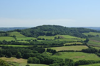
Lambert's Castle is an Iron Age hillfort in the county of Dorset in southwest England. Since 1981 it has been designated as a Site of Special Scientific Interest (SSSI) on account of its geology, archaeology and ecology. The hillfort is designated a scheduled monument together with a bowl barrow, the sites of a post-medieval fair and a telegraph station. The site was on the Heritage at Risk Register but was removed in 2022 as a result of the Hillforts and Habitats Project.

The Marshwood Vale is a low-lying, bowl-shaped valley of Lower Lias clay, in the western tip of the county of Dorset in south-west England. It lies to the north of the A35 trunk road between the towns of Bridport and Lyme Regis, and to the south of the two highest hills in Dorset, Lewesdon Hill (279m) and Pilsdon Pen (277m). It is drained by the River Char, which flows south-west to its mouth on the English Channel coast at Charmouth. All of the vale lies within the Dorset Area of Outstanding Natural Beauty.

Winterborne Came is a small dispersed settlement and civil parish in the county of Dorset in England, situated in the west of the county, approximately 1 mile (1.6 km) south-east of the county town Dorchester. Dorset County Council's 2013 mid-year estimate of the parish population was 40.

The Church of St Candida and Holy Cross is an Anglican church in Whitchurch Canonicorum, Dorset, England. A Saxon church stood on the site but nothing remains of that structure. The earliest parts of the church date from the 12th century when it was rebuilt by Benedictine monks. Further major rebuilding work took place in the 13th century and in the 14th century the church's prominent tower was constructed. The church features some Norman architectural features but is predominantly Early English and Perpendicular. George Somers, founder of the colony of Bermuda, is buried under the vestry and the assassinated Bulgarian dissident Georgi Markov is interred in the churchyard. It is an active Church of England parish church in the deanery of Lyme Bay, the archdeaconry of Sherborne, and the diocese of Salisbury. It is one of only two parish churches in the country to have a shrine that contains the relics of their patron saint. The relics belong to St Candida to whom the church is dedicated. The church been designated by English Heritage as a Grade I listed building.

Nether Cerne is a hamlet and civil parish in the English county of Dorset. It lies within the Dorset unitary authority administrative area, about 5 miles (8.0 km) north of the county town Dorchester and 12 miles (19 km) south of Sherborne. The A352 road which connects those towns lies about 250 metres (270 yd) to the west. Dorset County Council's latest (2013) estimate of the parish population is 20.

Hardown Hill is a hill between Ryall and Morcombelake in the county of Dorset, England. It rises west of the South Dorset Downs, close to the Dorset coast, and overlooks the Marshwood Vale to the north. Its prominence qualifies it as one of Dorset's four Marilyns and it is listed as one of the "top 12 Dorset views to take your breath away" by Dorset's official tourist website.

Telegraph Hill is a hill about 1 mile northwest of Minterne Magna and about 10 miles north of Dorchester in the county of Dorset, England. Its prominence qualifies it as one of the so-called HuMPs.

Payne's Down is a prominent hill, 211 metres (692 ft) high, some 10 kilometres east-northeast of Axminster and 1 kilometre northwest of Birdsmoorgate, in the county of Dorset in southern England. Its prominence of 62 metres (203 ft) means it is listed as one of the Tumps. It is located within the Dorset Downs.
