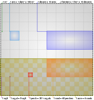
The acre is a unit of land area used in the British imperial and the United States customary systems. It is traditionally defined as the area of one chain by one furlong, which is exactly equal to 10 square chains, 1⁄640 of a square mile, 4,840 square yards, or 43,560 square feet, and approximately 4,047 m2, or about 40% of a hectare. Based upon the international yard and pound agreement of 1959, an acre may be declared as exactly 4,046.8564224 square metres. The acre is sometimes abbreviated ac but is usually spelled out as the word "acre".
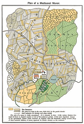
The open-field system was the prevalent agricultural system in much of Europe during the Middle Ages and lasted into the 20th century in Russia, Iran, and Turkey. Each manor or village had two or three large fields, usually several hundred acres each, which were divided into many narrow strips of land. The strips or selions were cultivated by peasants, often called tenants or serfs. The holdings of a manor also included woodland and pasture areas for common usage and fields belonging to the lord of the manor and the religious authorities, usually Roman Catholics in medieval Western Europe. The farmers customarily lived in separate houses in a nucleated village with a much larger manor house and church nearby. The open-field system necessitated co-operation among the residents of the manor.

The Duchy of Lancaster is a private estate of the British sovereign. The estate has its origins in the lands held by the medieval Dukes of Lancaster, which came under the direct control of the monarch when Henry Bolingbroke, the then duke of Lancaster, ascended the throne in 1399. In 1461 King Edward IV confirmed that the Duchy would be inherited by the monarch, but held separately from the Crown Estate, the other assets which belong to the monarch.

Knoydart is a peninsula in Lochaber, Highland, on the west coast of Scotland. Knoydart is sandwiched between Lochs Nevis and Hourn — often translated as "Loch Heaven" and "Loch Hell" respectively, although the somewhat poetic nature of these derivations is disputed. Forming the northern part of what is traditionally known as na Garbh-Chrìochan or "the Rough Bounds", because of its harsh terrain and remoteness, Knoydart is also referred to as "Britain's last wilderness". It is only accessible by boat, or by a 16-mile (26 km) walk through rough country, and the seven miles (11 km) of tarred road are not connected to the UK road system.
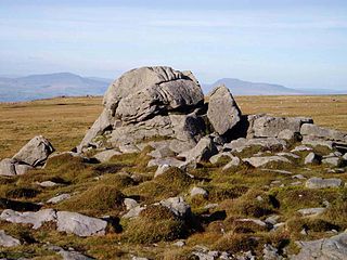
The Forest of Bowland, also known as the Bowland Fells and formerly the Chase of Bowland, is an area of gritstone fells, deep valleys and peat moorland, mostly in north-east Lancashire, England, with a small part in North Yorkshire. It is a western outlier of the Pennines.

Langholm, also known colloquially as the "Muckle Toon", is a burgh in Dumfries and Galloway, southern Scotland. Langholm lies between four hills in the valley of the River Esk in the Southern Uplands.
Land trusts are nonprofit organizations which own and manage land, and sometimes waters. There are three common types of land trust, distinguished from one another by the ways in which they are legally structured and by the purposes for which they are organized and operated:
The Crown Estate is a collection of lands and holdings in the United Kingdom belonging to the British monarch as a corporation sole, making it "the sovereign's public estate", which is neither government property nor part of the monarch's private estate. The Crown Estate in England, Wales, and Northern Ireland is managed by the Crown Estate Commissioners. In Scotland, the Crown Estate is managed by Crown Estate Scotland, since the Scottish estate was devolved in 2017.
Common land is collective land in which all persons have certain common rights, such as to allow their livestock to graze upon it, to collect wood, or to cut turf for fuel.

Crofting is a form of land tenure and small-scale food production peculiar to the Scottish Highlands, the islands of Scotland, and formerly on the Isle of Man. Within the 19th-century townships, individual crofts were established on the better land, and a large area of poorer-quality hill ground was shared by all the crofters of the township for grazing of their livestock. In the 21st century, crofting is found predominantly in the rural Western and Northern Isles and in the coastal fringes of the western and northern Scottish mainland.

Glen Affric is a glen south-west of the village of Cannich in the Highland region of Scotland, some 15 miles west of Loch Ness. The River Affric runs along its length, passing through Loch Affric and Loch Beinn a' Mheadhoin. A minor public road reaches as far as the end of Loch Beinn a' Mheadhoin, but beyond that point only rough tracks and footpaths continue along the glen.

Land reform in Scotland is the ongoing process by which the ownership of land, its distribution and the law which governs it is modified, reformed and modernised by property and regulatory law.

The Swinton Estate is a large privately owned estate in North Yorkshire, England. It comprises some 20,000 acres (8,100 ha) of countryside in the Nidderdale Area of Outstanding Natural Beauty, extending 10 miles (16 km) west from the River Ure near Masham. The estate includes Swinton Park, the seat of the Danby family and of the Cunliffe-Lister family, an English country house in Swinton near Masham. It is set in 200 acres (81 ha) of parkland, lakes and gardens. The house is a Grade II* listed building, and now operates as the 42-bedroom Swinton Park Hotel.
Four major land reforms have taken place in Romania: in 1864, 1921, 1945 and 1991. The first sought to undo the feudal structure that had persisted after the unification of the Danubian Principalities in 1859; the second, more drastic reform, tried to resolve lingering peasant discontent and create social harmony after the upheaval of World War I and extensive territorial expansion; the third, imposed by a mainly Communist government, did away with the remaining influence of the landed aristocracy but was itself soon undone by collectivisation, which the fourth then unravelled, leading to almost universal private ownership of land today.

Alvie is a small crofting hamlet, a working Scottish highland estate and civil parish, located on the south shore of Loch Alvie in the Badenoch and Strathspey area of Inverness-shire, within the Scottish council area of Highland.

Agriculture in the United Kingdom uses 69% of the country's land area, employs 1% of its workforce and contributes 0.5% of its gross value added. The UK currently produces about 54% of its domestic food consumption.
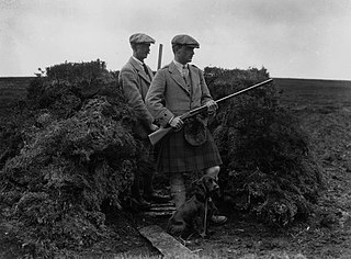
Driven grouse shooting is a field sport in the United Kingdom involving the shooting of red grouse. It is one of two forms of the sport, the other is walked-up shooting. Driven grouse shooting involves grouse being driven to fly over people with shotguns in fixed positions. In walked-up shooting the participants walk forward in a line and flush the birds as they go. Walked-up shooting is more physically demanding than a driven shoot and typically involves fewer birds being shot.
Agrarian reform and land reform have been a recurring theme of enormous consequence in world history. They are often highly political and have been achieved in many countries.

The Scottish Land Commission was established by the Scottish Government following the passage of the Land Reform (Scotland) Act 2016 by the Scottish Parliament; the Commission also incorporates the work of the Tenant Farming Commissioner. The Lands Commissioners, who constitute the Commission, have functions relating to land in Scotland, so that they address issues which relate to ownership of land, land rights, management of land, and use of land. The Tenant Farming Commissioner has the aim of improving the relationship between tenant farmers and land owners, and can create codes of practice, provide practical guidance, and must consult on such matters. The Tenant Farming Commissioner cannot be an agricultural landlord or agricultural tenant, and will develop codes of practice which are in addition to the law and the jurisdiction of the Scottish Land Court.
A private forest is a forest that is not owned by municipal authorities, church authorities or the state. It can refer to woodland owned by a natural or juridical person or a partnership.It is the forest which is planted, nurtured or conserved in any private land.


