Friedland is a town in the district Mecklenburgische Seenplatte, Mecklenburg-Vorpommern, Germany.

The Recknitz is a river in Mecklenburg-Vorpommern in northeastern Germany. The Recknitz's glacial valley stretches as far south as the heights at Glasewitz near Güstrow. The river has no definite source, but rather builds up from streams and drainage ditches. The ditches of the Schaalbeke and Pludderbach have their water flow split between Liessow and Laage, but most of the water flows north as the Recknitz, while the lesser flow, called the Augraben, runs south to the river Nebel.

Frýdlant nad Ostravicí is a town in the Moravian-Silesian Region of the Czech Republic. It has about 10,000 inhabitants. It lies on the Ostravice River at the foot of Lysá hora, the highest mountain of the Moravian-Silesian Beskids. In the past it was an important ironworks center. Today it is mainly a holiday resort.

Jarmen is a town in the Vorpommern-Greifswald district, in Mecklenburg-Western Pomerania, Germany. It is situated on the southern bank of the river Peene, 20 km south of Greifswald, in the historic region of Pomerania.

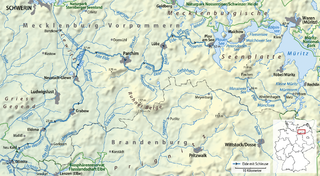
The Elde is a river in northern Germany, a right tributary of the Elbe. Its total length is 220 kilometres (140 mi). The Elde originates near Altenhof, south of Malchow. It first flows southeast towards the southern end of Lake Müritz, which it enters at Vipperow. It flows out of the Müritz at its northern end, near Waren. It turns west, and flows through a series of small lakes, and along the town of Malchow, until the Plauer See. It flows out of the Plauer See at Plau am See, and continues west and southwest through Lübz, Parchim, Neustadt-Glewe, Grabow and Eldena, and flows into the Elbe at Dömitz. Near Eldena, the Alte Elde branches off and flows into the Löcknitz near Eldenburg, part of Lenzen (Elbe). For much of its length, 180 kilometres (110 mi), it forms the navigable Müritz-Elde-Wasserstraße, with 17 locks. The Elde is murky, due to the fast erosion of the valley around it.

Wittendörp is a municipality in the administrative district of Ludwigslust-Parchim in Mecklenburg-Vorpommern, Germany. The municipality has a seat in the Amt of Wittenburg from where it is administered. The municipality is about 25 kilometres west of Schwerin in the north of the administrative district Ludwigslust-Parchim and borders on the administrative district of Nordwestmecklenburg in the north. The river Schilde flows through the municipality.

The Ryck is a river in Mecklenburg-Vorpommern, Germany.

Randow is a river in the Uckermark region of Brandenburg and the Vorpommern region of Mecklenburg-Vorpommern, in part constituting these regions' border. An ancient name is Lochnitza, the town of Löcknitz derived its name from it. Since 1700, Randow is exclusively used.

The Tarnitz is a tributary of the Löcknitz in southwest Mecklenburg-Vorpommern and north Brandenburg in Germany.

Veste Landskron or Lanzkron is a Renaissance water castle in the municipality Neuendorf B, Vorpommern-Greifswald district, Mecklenburg-Vorpommern, Germany. Built between 1576 and 1579, it deteriorated in the 17th century. Its ruins are a tourist attraction and frequently the site of cultural events.

Meynbach is a river of northeastern Germany. It flows from its source near Hühnerland in a generally western direction along the border between Brandenburg and Mecklenburg-Vorpommern. It flows into the Alte Elde near Krinitz. A branch of the Meynbach flows from Hühnerland to the east, and joins the Tarnitz north of Reckenzin.

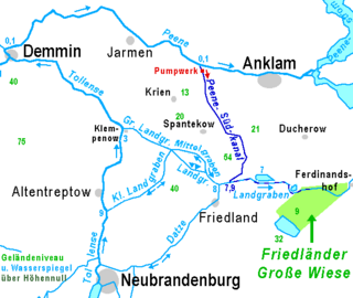
The Datze is a river of Mecklenburg-Vorpommern, Germany. It forms a pseudobifurcation: its water northeast of Warlin flows towards Friedland and the Landgraben, and its water southwest of Warlin flows towards Neubrandenburg and the Tollense.

Delvenau is a 50-kilometre-long (31 mi) river in Herzogtum Lauenburg in Schleswig-Holstein, Germany. It begins in Büchen, flows to the Elbe–Lübeck Canal near its confluence with the Elbe in Lauenburg. The lower section between Bröthen and Lauenburg forms the border between Schleswig-Holstein and Mecklenburg-Vorpommern.

The Großer Landgraben is a river of Mecklenburg-Vorpommern, Germany. It is formed at the confluence of Landgraben, Kleiner Landgraben and Mittelgraben near Siedenbollentin. It flows into the Tollense in Klempenow.

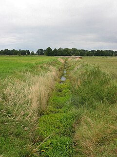
The Kleiner Landgraben is a small river of Mecklenburg-Vorpommern, Germany. Collecting the water of a wetland and lateral sources, it is drained in both directions, in the south into Tollense River, and to the north into the Großer Landgraben, another affluent of Tollense River. Therefore, Kleiner Landgraben is a pseudobifurcation. The meaning of Kleiner Landgraben is something like "Small Border Canal". For several centuries it was part of the border between Mecklenburg and Pomerania. The Landgraben drains one of the broad glacial valleys of Mecklenburg-Vorpommern. In these valleys, there is no strict discrimination between natural and artificial courses of water.
The region of Griese Gegend lies in southwestern Mecklenburg in Germany. In the northwest and north the region is bordered by the River Sude, the stream of the Strohkirchener Bach and its continuation as the New Canal. The region's southeastern border runs roughly from the town of Ludwigslust to Dömitz, in the southwest the River Rögnitz forms the boundary of the Griese Gegend from Woosmer to Lübtheen. The region forms a large triangle.

The Mecklenburg Elbe Valley Nature Park is part of the UNESCO biosphere reserve of Elbe River Landscape, which is over 400 river kilometres long and which runs through the five German states of Saxony-Anhalt, Brandenburg, Lower Saxony, Mecklenburg-Vorpommern and Schleswig-Holstein. It lies in the district of Ludwigslust-Parchim in Mecklenburg-Vorpommern. The nature park was called into existence in 1990 and legally established by act of state in 1998. It has an area of 426 km2 (164 sq mi).

Mecklenburgische Seenplatte I – Vorpommern-Greifswald II is an electoral constituency represented in the Bundestag. It elects one member via first-past-the-post voting. Under the current constituency numbering system, it is designated as constituency 16. It is located in southeast Mecklenburg-Vorpommern, comprising the most of the Vorpommern-Greifswald district and southeast parts of the Mecklenburgische Seenplatte district.


