Related Research Articles
In aviation, visual flight rules (VFR) are a set of regulations under which a pilot operates an aircraft in weather conditions generally clear enough to allow the pilot to see where the aircraft is going. Specifically, the weather must be better than basic VFR weather minima, i.e., in visual meteorological conditions (VMC), as specified in the rules of the relevant aviation authority. The pilot must be able to operate the aircraft with visual reference to the ground, and by visually avoiding obstructions and other aircraft.

An airport is an aerodrome with extended facilities, mostly for commercial air transport. Airports usually consist of a landing area, which comprises an aerially accessible open space including at least one operationally active surface such as a runway for a plane to take off and to land or a helipad, and often includes adjacent utility buildings such as control towers, hangars and terminals, to maintain and monitor aircraft. Larger airports may have airport aprons, taxiway bridges, air traffic control centres, passenger facilities such as restaurants and lounges, and emergency services. In some countries, the US in particular, airports also typically have one or more fixed-base operators, serving general aviation.

Air traffic control (ATC) is a service provided by ground-based air traffic controllers who direct aircraft on the ground and through a given section of controlled airspace, and can provide advisory services to aircraft in non-controlled airspace. The primary purpose of ATC worldwide is to prevent collisions, organize and expedite the flow of air traffic, and provide information and other support for pilots.

According to the International Civil Aviation Organization (ICAO), a runway is a "defined rectangular area on a land aerodrome prepared for the landing and takeoff of aircraft". Runways may be a human-made surface or a natural surface. Runways, taxiways and ramps, are sometimes referred to as "tarmac", though very few runways are built using tarmac. Takeoff and landing areas defined on the surface of water for seaplanes are generally referred to as waterways. Runway lengths are now commonly given in meters worldwide, except in North America where feet are commonly used.

An airfield traffic pattern is a standard path followed by aircraft when taking off or landing while maintaining visual contact with the airfield.

An aerodrome or airdrome is a location from which aircraft flight operations take place, regardless of whether they involve air cargo, passengers, or neither, and regardless of whether it is for public or private use. Aerodromes include small general aviation airfields, large commercial airports, and military air bases.
Airspace is the portion of the atmosphere controlled by a country above its territory, including its territorial waters or, more generally, any specific three-dimensional portion of the atmosphere. It is not the same as outer space which is the expanse or space outside the Earth and aerospace which is the general term for Earth's atmosphere and the outer space within the planet's vicinity. History:
The world's navigable airspace is divided into three-dimensional segments, each of which is assigned to a specific class. Most nations adhere to the classification specified by the International Civil Aviation Organization (ICAO) and described below, though they might use only some of the classes defined below, and significantly alter the exact rules and requirements. Similarly, individual nations may also designate special use airspace (SUA) with further rules for reasons of national security or safety.

Naval Air Station (NAS) Oceana or NAS Oceana is a United States Navy Naval Air Station located in Virginia Beach, Virginia.
The Airports Authority of India (AAI) is a statutory body under the ownership of the Ministry of Civil Aviation, Government of India. It is responsible for creating, upgrading, maintaining, and managing civil aviation infrastructure in India. It provides Communication Navigation Surveillance/Air Traffic Management (CNS/ATM) services over the Indian airspace and adjoining oceanic areas. AAI currently manages a total of 137 airports, including 34 international airports, 10 Customs Airports, 81 domestic airports, and 23 Civil enclaves at Defence airfields. AAI also has ground installations at all airports and 25 other locations to ensure the safety of aircraft operations. AAI covers all major air routes over the Indian landmass via 29 Radar installations at 11 locations along with 700 VOR/DVOR installations co-located with Distance Measuring Equipment (DME). 52 runways are provided with Instrument landing system (ILS) installations with Night Landing Facilities at most of these airports and an Automatic Message Switching System at 15 Airports.

Naval Auxiliary Landing Field (NALF) San Clemente Island, also known as Frederick Sherman Field, is a military airport located on San Clemente Island, in Los Angeles County, California, United States. It has been owned by the United States Navy since 1937.

A runway safety area (RSA) or runway end safety area is defined as "the surface surrounding the runway prepared or suitable for reducing the risk of damage to airplanes in the event of an undershoot, overshoot, or excursion from the runway."
The National Airspace System (NAS) is the airspace, navigation facilities and airports of the United States along with their associated information, services, rules, regulations, policies, procedures, personnel and equipment. It includes components shared jointly with the military. It is one of the most complex aviation systems in the world, and services air travel in the United States and over large portions of the world's oceans.
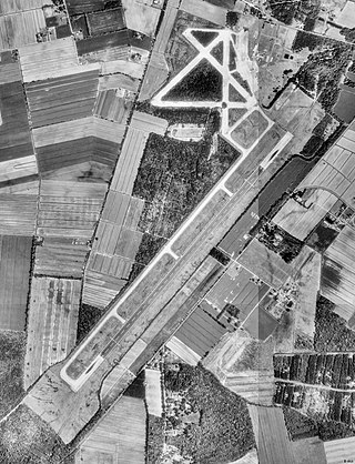
Flagler Executive Airport (ICAO: KFIN, FAA LID: FIN) is a county-owned public-use airport located three miles (5 km) east of the central business district of Bunnell, a city in Flagler County, Florida, United States. The airport's former FAA location identifiers were X47 and XFL. The airfield was originally constructed by the United States Navy during World War II as Naval Outlying Field Bunnell (NOLF Bunnell), an auxiliary airfield for flight training operations originating from nearby Naval Air Station Jacksonville, NAS Daytona Beach and NAS DeLand. Following the end of the war, the airfield was transferred from the Navy to Flagler County for use as a general aviation airport.
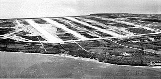
North Field was a World War II airfield on Tinian in the Mariana Islands. Abandoned after the war, today North Field is a tourist attraction. Along with several adjacent beaches on which U.S. Marines landed during the Battle of Tinian, the airfield is the major component of the National Historic Landmark District Tinian Landing Beaches, Ushi Point Field, Tinian Island.

Twentynine Palms Strategic Expeditionary Landing Field or Twentynine Palms SELF is a military use airfield located nine nautical miles (17 km) northwest of the central business district of Twentynine Palms, a city in San Bernardino County, California, United States. The SELF is the largest expeditionary airfield (EAF) operated by the United States Marine Corps. It is also known as the Twentynine Palms EAF and is located at the Marine Corps Air Ground Combat Center (MCAGCC) Twentynine Palms.
Morse Field is a former military airfield located approximately 12 miles (19 km) south-southwest of Naʻālehu, Hawaii. It was also known as South Cape Airport, South Point Air Force Station, or Ka Lae Military Reservation. It is now abandoned.
Naval Auxiliary Landing Field Fentress is a military use airport located in Chesapeake, Virginia. This military airport is owned by the U.S. Navy and is under the operational control of Naval Air Station Oceana, Virginia. The airfield primarily supports day and night Field Carrier Landing Practice (FCLP) operations by US Navy and US Marine Corps F/A-18 Hornet, and US Navy F/A-18 Super Hornet, E-2 Hawkeye and C-2 Greyhound aircraft based in Virginia and the Carolinas.
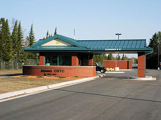
Alpena Combat Readiness Training Center is a Michigan Air National Guard training facility. It is located 7.1 miles (11.4 km) west-northwest of Alpena, Michigan.

The Cuban Revolutionary Air and Air Defense Force commonly abbreviated to DAAFAR in both Spanish and English, is the air force of Cuba.
References
- "landing area". TheFreeDictionary.com. 2012. Retrieved 2014-09-10.